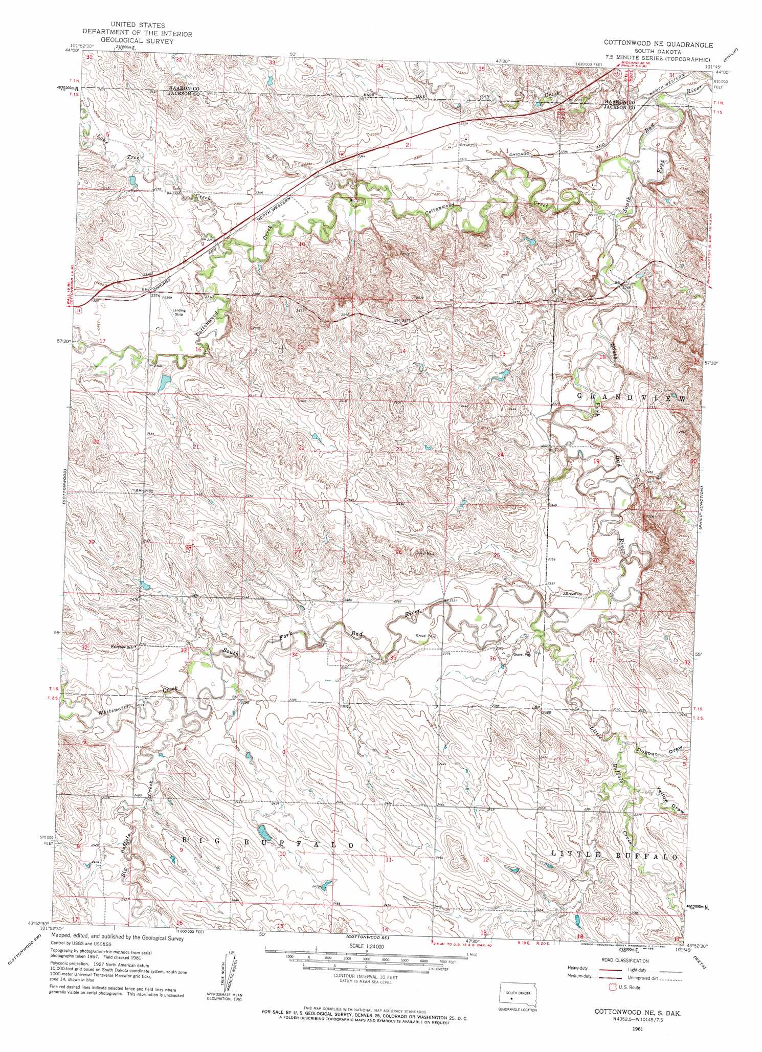
Cottonwood Ne Topo Map South Dakota
To zoom in, hover over the map of Cottonwood Ne
USGS Topo Quad 43101h7 - 1:24,000 scale
| Topo Map Name: | Cottonwood Ne |
| USGS Topo Quad ID: | 43101h7 |
| Print Size: | ca. 21 1/4" wide x 27" high |
| Southeast Coordinates: | 43.875° N latitude / 101.75° W longitude |
| Map Center Coordinates: | 43.9375° N latitude / 101.8125° W longitude |
| U.S. State: | SD |
| Filename: | o43101h7.jpg |
| Download Map JPG Image: | Cottonwood Ne topo map 1:24,000 scale |
| Map Type: | Topographic |
| Topo Series: | 7.5´ |
| Map Scale: | 1:24,000 |
| Source of Map Images: | United States Geological Survey (USGS) |
| Alternate Map Versions: |
Cottonwood NE SD 1961, updated 1963 Download PDF Buy paper map Cottonwood NE SD 1961, updated 1963 Download PDF Buy paper map Cottonwood NE SD 2012 Download PDF Buy paper map Cottonwood NE SD 2015 Download PDF Buy paper map |
| FStopo: | US Forest Service topo Cottonwood NE is available: Download FStopo PDF Download FStopo TIF |
1:24,000 Topo Quads surrounding Cottonwood Ne
Horse Tooth |
Grindstone |
Grindstone Butte |
Elevenmile Corner |
Lucerne |
Elm Creek Ranch |
Grindstone Sw |
Bowen Ranch |
Philip |
Philip Se |
Wall Ne |
Cottonwood |
Cottonwood Ne |
Philip Junction |
Kadoka Ne |
Wall Se |
Cottonwood Sw |
Cottonwood Se |
Weta |
Kadoka |
Conata Ne |
Interior |
School Section Butte |
Wanblee Nw |
Wanblee Ne |
> Back to 43101e1 at 1:100,000 scale
> Back to 43100a1 at 1:250,000 scale
> Back to U.S. Topo Maps home
Cottonwood Ne topo map: Gazetteer
Cottonwood Ne: Dams
Cottonwood Field Station Dam elevation 726m 2381′Ferdig Number 1 Dam elevation 723m 2372′
Cottonwood Ne: Streams
Big Buffalo Creek elevation 723m 2372′Cottonwood Creek elevation 682m 2237′
Dry Creek elevation 676m 2217′
Little Buffalo Creek elevation 707m 2319′
Lone Tree Creek elevation 708m 2322′
Whitewater Creek elevation 723m 2372′
Cottonwood Ne: Valleys
Dugout Draw elevation 720m 2362′Yellow Draw elevation 722m 2368′
Cottonwood Ne digital topo map on disk
Buy this Cottonwood Ne topo map showing relief, roads, GPS coordinates and other geographical features, as a high-resolution digital map file on DVD:
Eastern North Dakota & Eastern South Dakota
Buy digital topo maps: Eastern North Dakota & Eastern South Dakota