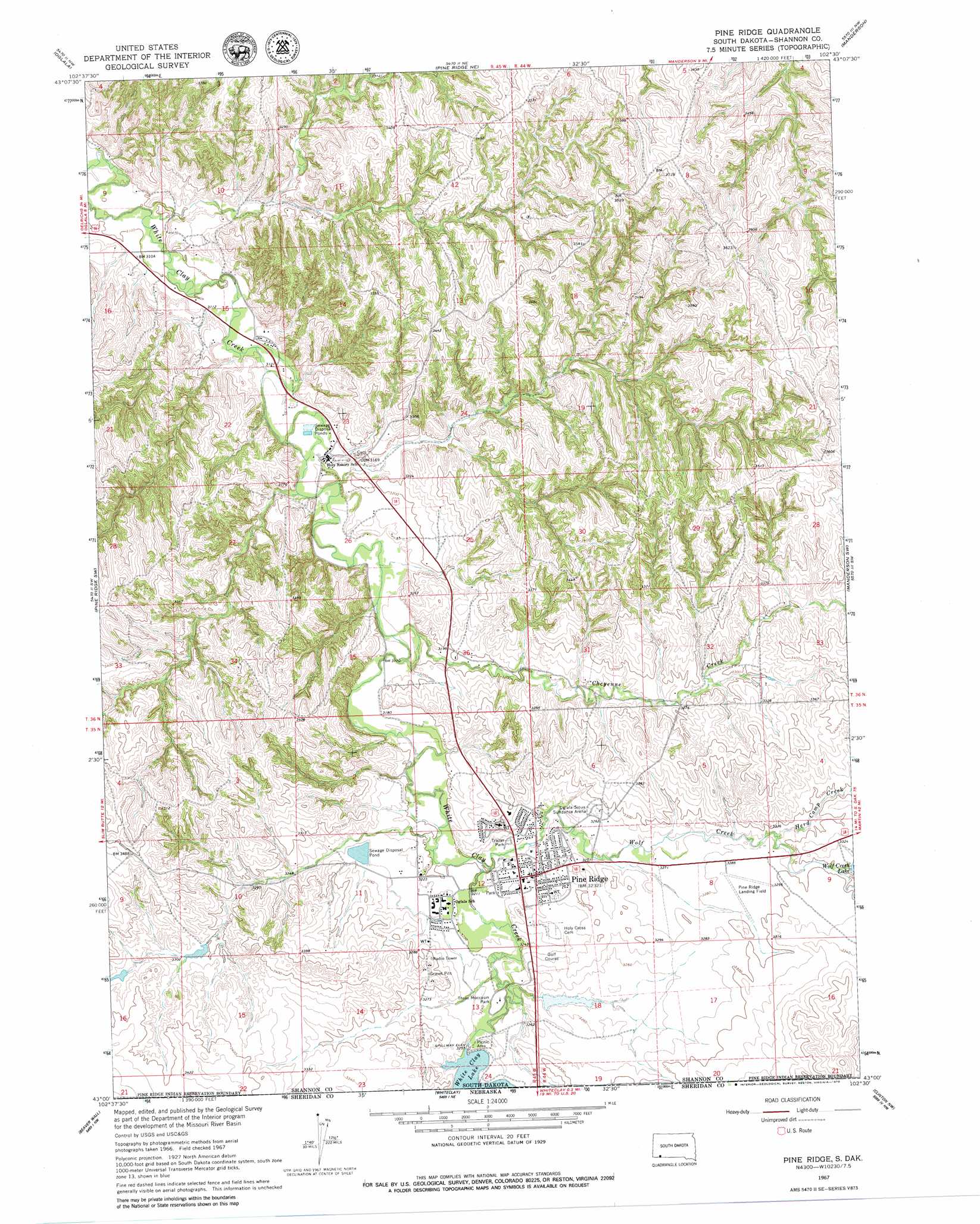
Pine Ridge Topo Map South Dakota
To zoom in, hover over the map of Pine Ridge
USGS Topo Quad 43102a5 - 1:24,000 scale
| Topo Map Name: | Pine Ridge |
| USGS Topo Quad ID: | 43102a5 |
| Print Size: | ca. 21 1/4" wide x 27" high |
| Southeast Coordinates: | 43° N latitude / 102.5° W longitude |
| Map Center Coordinates: | 43.0625° N latitude / 102.5625° W longitude |
| U.S. State: | SD |
| Filename: | o43102a5.jpg |
| Download Map JPG Image: | Pine Ridge topo map 1:24,000 scale |
| Map Type: | Topographic |
| Topo Series: | 7.5´ |
| Map Scale: | 1:24,000 |
| Source of Map Images: | United States Geological Survey (USGS) |
| Alternate Map Versions: |
Pine Ridge SD 1967, updated 1969 Download PDF Buy paper map Pine Ridge SD 1967, updated 1979 Download PDF Buy paper map Pine Ridge SD 2012 Download PDF Buy paper map Pine Ridge SD 2015 Download PDF Buy paper map |
1:24,000 Topo Quads surrounding Pine Ridge
Willow Creek |
Rockyford Sw |
Rockyford Se |
Evergreen |
|
Slim Butte Ne |
Oglala |
Pine Ridge Ne |
Manderson |
Wounded Knee |
Slim Butte |
Pine Ridge Sw |
Pine Ridge |
Manderson Sw |
Denby |
Chadron Ne |
Beaver Wall |
Whiteclay |
Clinton Nw |
Clinton Ne |
Bordeaux |
Whiteclay Sw |
Whiteclay Se |
Clinton Sw |
Clinton |
> Back to 43102a1 at 1:100,000 scale
> Back to 43102a1 at 1:250,000 scale
> Back to U.S. Topo Maps home
Pine Ridge topo map: Gazetteer
Pine Ridge: Airports
Pine Ridge Landing Field elevation 1007m 3303′Pine Ridge: Dams
White Clay Dam elevation 993m 3257′Wolf Creek Lake Dam elevation 1007m 3303′
Pine Ridge: Parks
Three Moccasin Park elevation 984m 3228′Pine Ridge: Populated Places
Pine Ridge elevation 988m 3241′Pine Ridge: Reservoirs
White Clay Lake elevation 993m 3257′White Clay Lake elevation 992m 3254′
Wolf Creek Lake elevation 1007m 3303′
Pine Ridge: Streams
Cheyenne Creek elevation 963m 3159′East Prong Wolf Creek elevation 1006m 3300′
Herd Camp Creek elevation 1000m 3280′
South Prong Wolf Creek elevation 1006m 3300′
Wolf Creek elevation 976m 3202′
Pine Ridge digital topo map on disk
Buy this Pine Ridge topo map showing relief, roads, GPS coordinates and other geographical features, as a high-resolution digital map file on DVD:
Eastern Wyoming & Western South Dakota
Buy digital topo maps: Eastern Wyoming & Western South Dakota