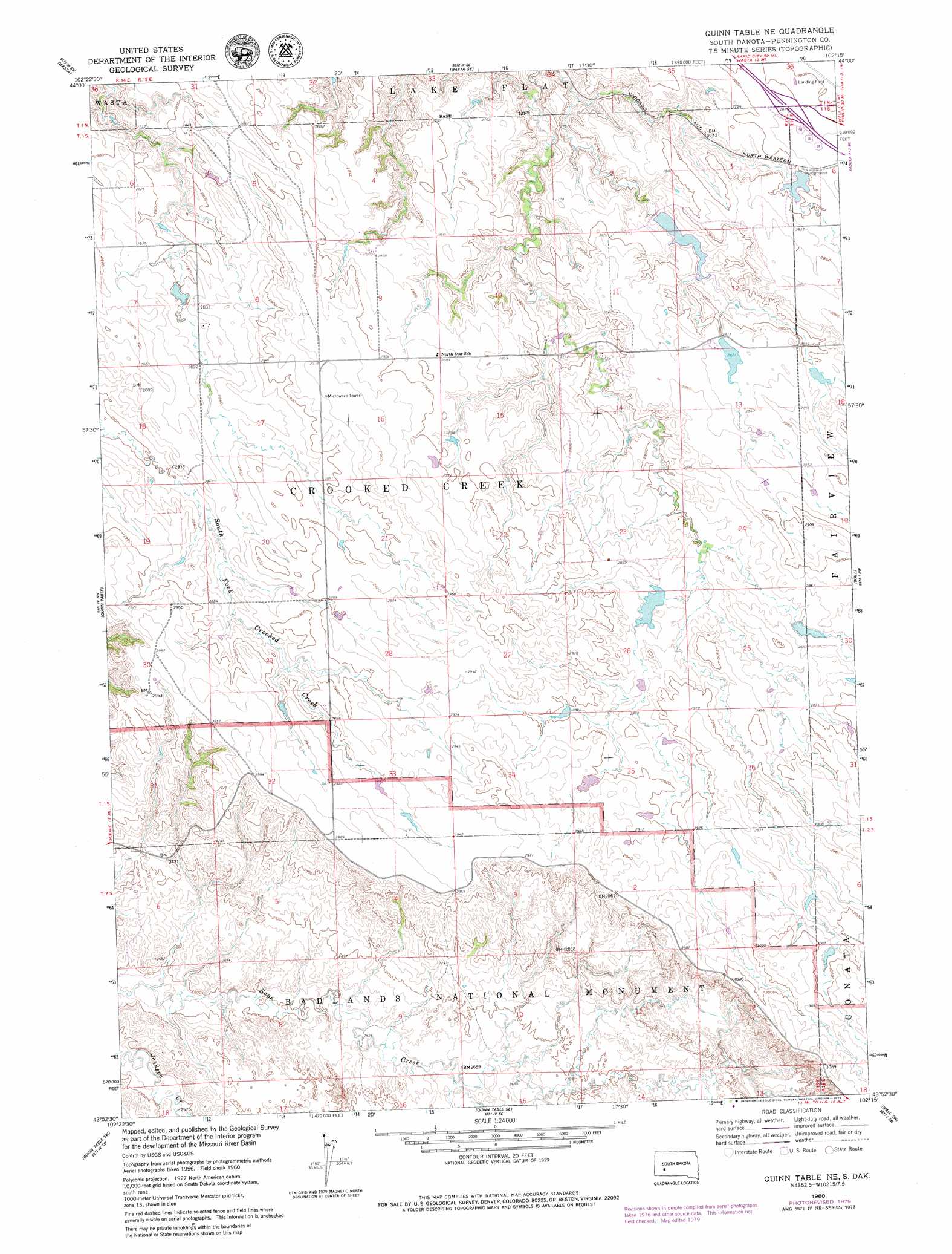
Quinn Table Ne Topo Map South Dakota
To zoom in, hover over the map of Quinn Table Ne
USGS Topo Quad 43102h3 - 1:24,000 scale
| Topo Map Name: | Quinn Table Ne |
| USGS Topo Quad ID: | 43102h3 |
| Print Size: | ca. 21 1/4" wide x 27" high |
| Southeast Coordinates: | 43.875° N latitude / 102.25° W longitude |
| Map Center Coordinates: | 43.9375° N latitude / 102.3125° W longitude |
| U.S. State: | SD |
| Filename: | o43102h3.jpg |
| Download Map JPG Image: | Quinn Table Ne topo map 1:24,000 scale |
| Map Type: | Topographic |
| Topo Series: | 7.5´ |
| Map Scale: | 1:24,000 |
| Source of Map Images: | United States Geological Survey (USGS) |
| Alternate Map Versions: |
Quinn Table NE SD 1960, updated 1961 Download PDF Buy paper map Quinn Table NE SD 1960, updated 1979 Download PDF Buy paper map Quinn Table NE SD 2012 Download PDF Buy paper map Quinn Table NE SD 2015 Download PDF Buy paper map |
| FStopo: | US Forest Service topo Quinn Table NE is available: Download FStopo PDF Download FStopo TIF |
1:24,000 Topo Quads surrounding Quinn Table Ne
Owanka Ne |
Wasta Nw |
Wasta Ne |
Pedrow 4 Nw |
Horse Tooth |
Owanka |
Wasta |
Wasta Se |
Lake Hill |
Elm Creek Ranch |
Brennan Flat |
Quinn Table |
Quinn Table Ne |
Wall |
Wall Ne |
Scenic |
Quinn Table Sw |
Quinn Table Se |
Wall Sw |
Wall Se |
Sheep Mountain Table |
Imlay |
Bouquet Table |
Conata |
Conata Ne |
> Back to 43102e1 at 1:100,000 scale
> Back to 43102a1 at 1:250,000 scale
> Back to U.S. Topo Maps home
Quinn Table Ne topo map: Gazetteer
Quinn Table Ne: Airports
Wall Municipal Airport elevation 854m 2801′Quinn Table Ne: Dams
Bruce Dam elevation 864m 2834′Crowndam Dam elevation 854m 2801′
George Knapp Dam elevation 860m 2821′
New Wall Lake Dam elevation 835m 2739′
Old Town Dam elevation 850m 2788′
Roy Schull Number 1 Dam elevation 848m 2782′
Roy Schull Number 2 Dam elevation 871m 2857′
Quinn Table Ne digital topo map on disk
Buy this Quinn Table Ne topo map showing relief, roads, GPS coordinates and other geographical features, as a high-resolution digital map file on DVD:
Eastern Wyoming & Western South Dakota
Buy digital topo maps: Eastern Wyoming & Western South Dakota