Angostura Reservoir Topo Map South Dakota
To zoom in, hover over the map of Angostura Reservoir
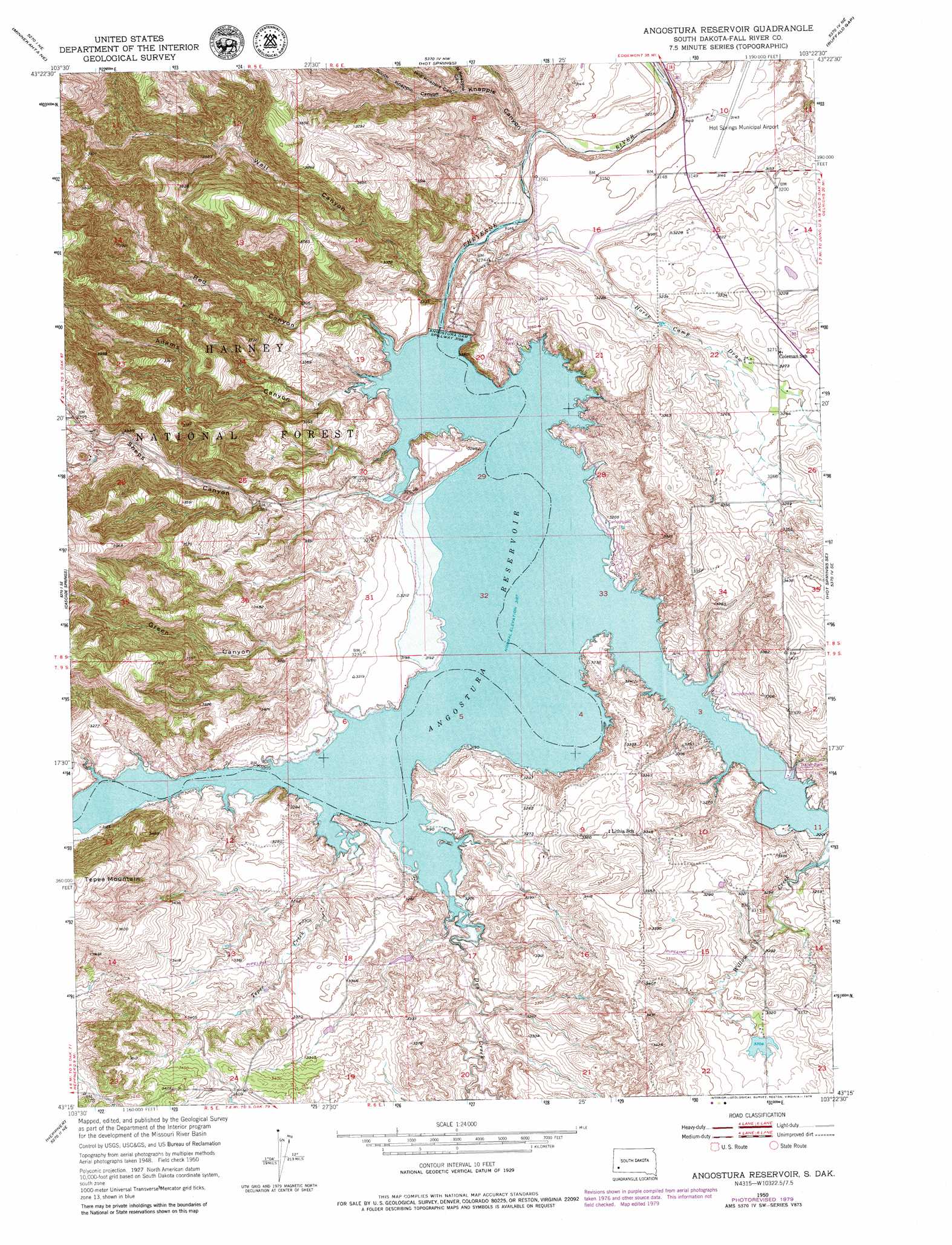
USGS Topo Quad 43103c4 - 1:24,000 scale
| Topo Map Name: | Angostura Reservoir |
| USGS Topo Quad ID: | 43103c4 |
| Print Size: | ca. 21 1/4" wide x 27" high |
| Southeast Coordinates: | 43.25° N latitude / 103.375° W longitude |
| Map Center Coordinates: | 43.3125° N latitude / 103.4375° W longitude |
| U.S. State: | SD |
| Filename: | o43103c4.jpg |
| Download Map JPG Image: | Angostura Reservoir topo map 1:24,000 scale |
| Map Type: | Topographic |
| Topo Series: | 7.5´ |
| Map Scale: | 1:24,000 |
| Source of Map Images: | United States Geological Survey (USGS) |
| Alternate Map Versions: |
Angostura Reservoir SD 1950, updated 1952 Download PDF Buy paper map Angostura Reservoir SD 1950, updated 1974 Download PDF Buy paper map Angostura Reservoir SD 1950, updated 1979 Download PDF Buy paper map Angostura Reservoir SD 2012 Download PDF Buy paper map Angostura Reservoir SD 2015 Download PDF Buy paper map |
| FStopo: | US Forest Service topo Angostura Reservoir is available: Download FStopo PDF Download FStopo TIF |
1:24,000 Topo Quads surrounding Angostura Reservoir
Argyle |
Pringle |
Wind Cave |
Boland Ridge |
Fairburn Sw |
Minnekahta |
Minnekahta Ne |
Hot Springs |
Buffalo Gap |
Smithwick Nw |
Flint Hill |
Cascade Springs |
Angostura Reservoir |
Hot Springs Se |
Smithwick |
Rumford |
Heppner |
Lone Well Creek West |
Lone Well Creek East |
Oelrichs |
Ardmore |
Ardmore Se |
Black Banks Creek West |
Black Banks Creek East |
Oelrichs Sw |
> Back to 43103a1 at 1:100,000 scale
> Back to 43102a1 at 1:250,000 scale
> Back to U.S. Topo Maps home
Angostura Reservoir topo map: Gazetteer
Angostura Reservoir: Airports
Hot Springs Municipal Airport elevation 958m 3143′Angostura Reservoir: Dams
Angostura Dam elevation 961m 3152′Bailey Pond Number 1 Dam elevation 1017m 3336′
Peterspuddle Dam elevation 1008m 3307′
Angostura Reservoir: Parks
Angostura Reservoir State Recreation Area elevation 995m 3264′Angostura Reservoir: Post Offices
Lithia Post Office (historical) elevation 979m 3211′Angostura Reservoir: Reservoirs
Angostura Reservoir elevation 953m 3126′Angostura Reservoir: Streams
Dry Creek elevation 972m 3188′Horsehead Creek elevation 972m 3188′
Tepee Creek elevation 972m 3188′
Willow Creek elevation 973m 3192′
Angostura Reservoir: Summits
Tepee Mountain elevation 1155m 3789′Angostura Reservoir: Valleys
Adams Canyon elevation 972m 3188′Green Canyon elevation 972m 3188′
Horse Camp Draw elevation 932m 3057′
Knapple Canyon elevation 930m 3051′
Middle Knappie Canyon elevation 973m 3192′
North Knappie Canyon elevation 973m 3192′
Red Canyon elevation 972m 3188′
Sheps Canyon elevation 972m 3188′
South Knappie Canyon elevation 973m 3192′
Wall Canyon elevation 935m 3067′
Angostura Reservoir digital topo map on disk
Buy this Angostura Reservoir topo map showing relief, roads, GPS coordinates and other geographical features, as a high-resolution digital map file on DVD:
Eastern Wyoming & Western South Dakota
Buy digital topo maps: Eastern Wyoming & Western South Dakota