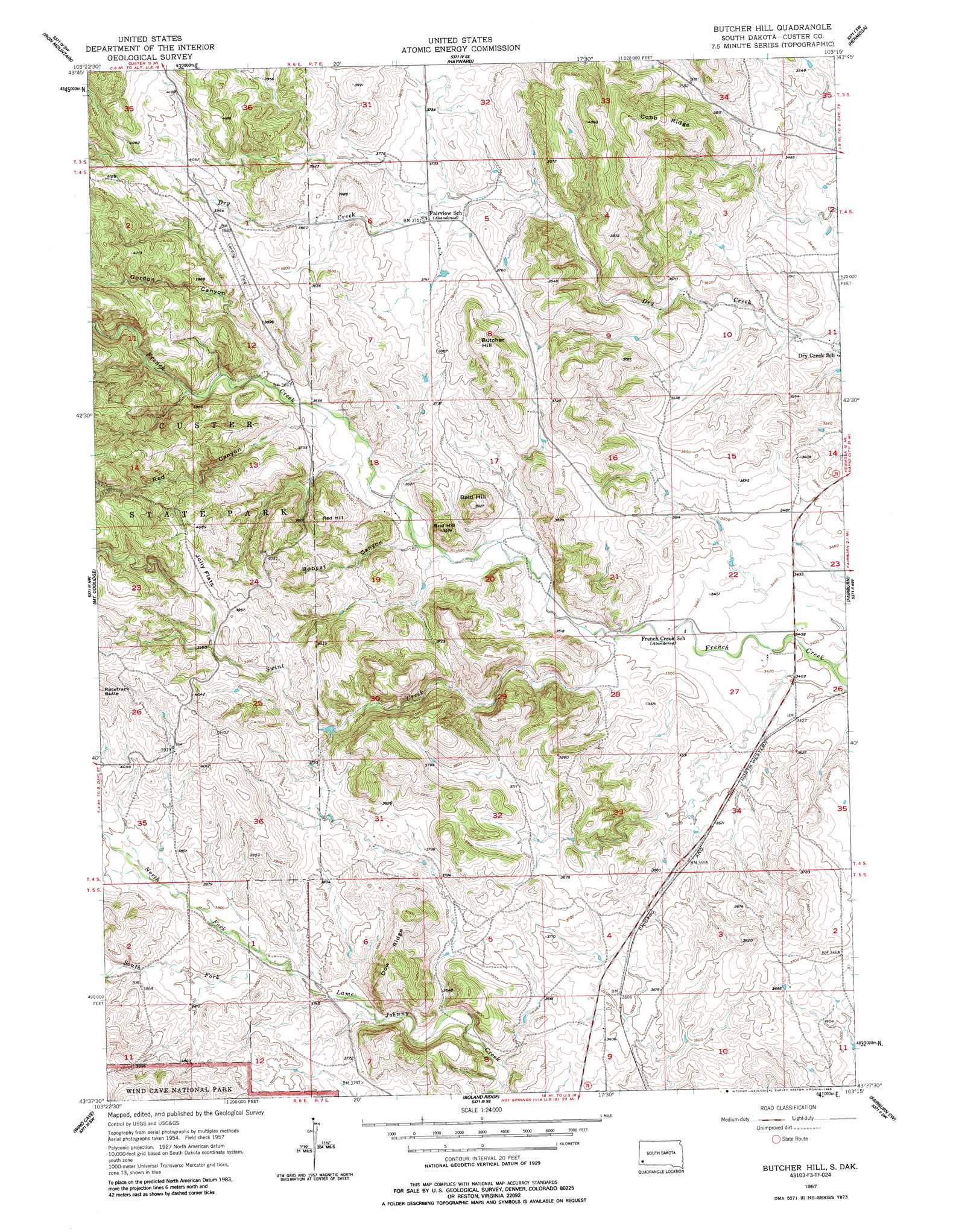
Butcher Hill Topo Map South Dakota
To zoom in, hover over the map of Butcher Hill
USGS Topo Quad 43103f3 - 1:24,000 scale
| Topo Map Name: | Butcher Hill |
| USGS Topo Quad ID: | 43103f3 |
| Print Size: | ca. 21 1/4" wide x 27" high |
| Southeast Coordinates: | 43.625° N latitude / 103.25° W longitude |
| Map Center Coordinates: | 43.6875° N latitude / 103.3125° W longitude |
| U.S. State: | SD |
| Filename: | o43103f3.jpg |
| Download Map JPG Image: | Butcher Hill topo map 1:24,000 scale |
| Map Type: | Topographic |
| Topo Series: | 7.5´ |
| Map Scale: | 1:24,000 |
| Source of Map Images: | United States Geological Survey (USGS) |
| Alternate Map Versions: |
Butcher Hill SD 1957, updated 1958 Download PDF Buy paper map Butcher Hill SD 1957, updated 1963 Download PDF Buy paper map Butcher Hill SD 1957, updated 1963 Download PDF Buy paper map Butcher Hill SD 1957, updated 1986 Download PDF Buy paper map Butcher Hill SD 1957, updated 1986 Download PDF Buy paper map Butcher Hill SD 2012 Download PDF Buy paper map Butcher Hill SD 2015 Download PDF Buy paper map |
1:24,000 Topo Quads surrounding Butcher Hill
Hill City |
Mount Rushmore |
Rockerville |
Hermosa Nw |
Hermosa Ne |
Custer |
Iron Mountain |
Hayward |
Hermosa |
Hermosa Se |
Cicero Peak |
Mount Coolidge |
Butcher Hill |
Fairburn |
Fairburn Ne |
Pringle |
Wind Cave |
Boland Ridge |
Fairburn Sw |
Fairburn Se |
Minnekahta Ne |
Hot Springs |
Buffalo Gap |
Smithwick Nw |
Smithwick Ne |
> Back to 43103e1 at 1:100,000 scale
> Back to 43102a1 at 1:250,000 scale
> Back to U.S. Topo Maps home
Butcher Hill topo map: Gazetteer
Butcher Hill: Airports
Custer State Park Airstrip elevation 1205m 3953′Butcher Hill: Dams
Gregorson Number 1 Dam elevation 1104m 3622′Smith Number 1 Dam elevation 1066m 3497′
Butcher Hill: Flats
Jolly Flats elevation 1228m 4028′Butcher Hill: Ridges
Cobb Ridge elevation 1194m 3917′Dow Ridge elevation 1251m 4104′
Butcher Hill: Streams
Dry Creek elevation 1128m 3700′North Fork Lame Johnny Creek elevation 1136m 3727′
South Fork Lame Johnny Creek elevation 1136m 3727′
Swint Creek elevation 1061m 3480′
Butcher Hill: Summits
Bald Hill elevation 1195m 3920′Bud Hill elevation 1191m 3907′
Butcher Hill elevation 1252m 4107′
Racetrack Butte elevation 1308m 4291′
Red Hill elevation 1227m 4025′
Butcher Hill: Valleys
Bobcat Canyon elevation 1104m 3622′Gordon Canyon elevation 1132m 3713′
Red Canyon elevation 1124m 3687′
Butcher Hill digital topo map on disk
Buy this Butcher Hill topo map showing relief, roads, GPS coordinates and other geographical features, as a high-resolution digital map file on DVD:
Eastern Wyoming & Western South Dakota
Buy digital topo maps: Eastern Wyoming & Western South Dakota