Mount Rushmore Topo Map South Dakota
To zoom in, hover over the map of Mount Rushmore
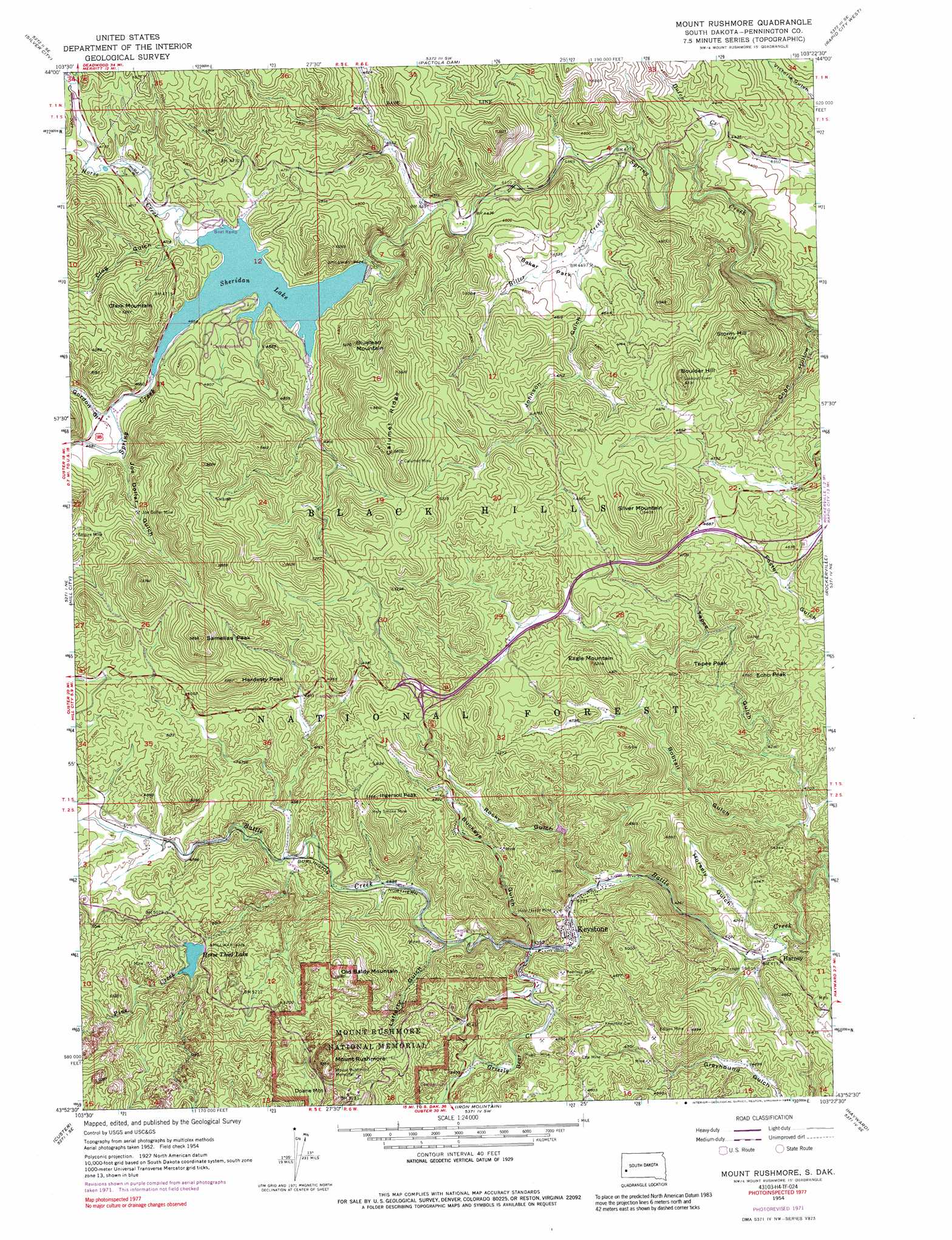
USGS Topo Quad 43103h4 - 1:24,000 scale
| Topo Map Name: | Mount Rushmore |
| USGS Topo Quad ID: | 43103h4 |
| Print Size: | ca. 21 1/4" wide x 27" high |
| Southeast Coordinates: | 43.875° N latitude / 103.375° W longitude |
| Map Center Coordinates: | 43.9375° N latitude / 103.4375° W longitude |
| U.S. State: | SD |
| Filename: | o43103h4.jpg |
| Download Map JPG Image: | Mount Rushmore topo map 1:24,000 scale |
| Map Type: | Topographic |
| Topo Series: | 7.5´ |
| Map Scale: | 1:24,000 |
| Source of Map Images: | United States Geological Survey (USGS) |
| Alternate Map Versions: |
Mount Rushmore SD 1954, updated 1955 Download PDF Buy paper map Mount Rushmore SD 1954, updated 1964 Download PDF Buy paper map Mount Rushmore SD 1954, updated 1972 Download PDF Buy paper map Mount Rushmore SD 1954, updated 1976 Download PDF Buy paper map Mount Rushmore SD 1954, updated 1989 Download PDF Buy paper map Mount Rushmore SD 2012 Download PDF Buy paper map Mount Rushmore SD 2015 Download PDF Buy paper map |
| FStopo: | US Forest Service topo Mount Rushmore is available: Download FStopo PDF Download FStopo TIF |
1:24,000 Topo Quads surrounding Mount Rushmore
Minnesota Ridge |
Nemo |
Piedmont |
Blackhawk |
Rapid City Nw |
Rochford |
Silver City |
Pactola Dam |
Rapid City West |
Rapid City East |
Medicine Mountain |
Hill City |
Mount Rushmore |
Rockerville |
Hermosa Nw |
Berne |
Custer |
Iron Mountain |
Hayward |
Hermosa |
Fourmile |
Cicero Peak |
Mount Coolidge |
Butcher Hill |
Fairburn |
> Back to 43103e1 at 1:100,000 scale
> Back to 43102a1 at 1:250,000 scale
> Back to U.S. Topo Maps home
Mount Rushmore topo map: Gazetteer
Mount Rushmore: Airports
Rushmore Airport elevation 1506m 4940′Mount Rushmore: Dams
Horse Thief Lake Dam elevation 1495m 4904′Sheridan Lake Dam elevation 1410m 4625′
Mount Rushmore: Flats
Baker Park elevation 1380m 4527′Mount Rushmore: Mines
Big Hit Mine elevation 1364m 4475′Big Shot Mine elevation 1549m 5082′
Bismark-Ida Florence Group Mine elevation 1443m 4734′
Bullion Mine elevation 1442m 4730′
Calumet Mine elevation 1637m 5370′
Columbia Mine elevation 1340m 4396′
Confidence Mine elevation 1338m 4389′
Dakota Calmet Mine elevation 1651m 5416′
Dan Patch Mine elevation 1377m 4517′
Edison Mine elevation 1382m 4534′
Edna Hazel Mine elevation 1571m 5154′
Egyptian Group Mine elevation 1439m 4721′
Elta Mine elevation 1395m 4576′
Forrest City Mine elevation 1644m 5393′
Giras Claim Mine elevation 1539m 5049′
Gold Hill Lode Mine elevation 1318m 4324′
Golden Slipper Mine elevation 1635m 5364′
Grand Island Group Mine elevation 1402m 4599′
Halcyon Mine elevation 1476m 4842′
Hardesty Homestead Mine elevation 1474m 4835′
Henry Tin Mine elevation 1326m 4350′
Holy Smoke Mine elevation 1529m 5016′
Holy Terror Mine elevation 1355m 4445′
Hugo Mine elevation 1381m 4530′
Ingersoll Mine elevation 1524m 5000′
Joe Dollar Mine elevation 1474m 4835′
Juniper Mine elevation 1448m 4750′
Keystone Mine elevation 1352m 4435′
King Mica Mine elevation 1361m 4465′
Legal Tender Mine elevation 1360m 4461′
Lucky Boy Mine elevation 1338m 4389′
Lucky Cuss Mine (historical) elevation 1438m 4717′
Nathaniel Pope Mine elevation 1432m 4698′
Peerless Mine elevation 1391m 4563′
Plate Mica Prospect Mine elevation 1377m 4517′
Samelias Mine elevation 1497m 4911′
Sitting Bull Mine elevation 1479m 4852′
Watson Mine elevation 1309m 4294′
Mount Rushmore: Parks
Mount Rushmore National Memorial elevation 1541m 5055′Mount Rushmore: Populated Places
Frenchtown (historical) elevation 1342m 4402′Harney elevation 1280m 4199′
Keystone elevation 1320m 4330′
Sheridan (historical) elevation 1410m 4625′
Mount Rushmore: Reservoirs
Horse Thief Lake elevation 1495m 4904′Sheridan Lake elevation 1410m 4625′
Mount Rushmore: Ridges
Calumet Ridge elevation 1664m 5459′Mount Rushmore: Streams
Bitter Creek elevation 1329m 4360′Dutch Creek elevation 1310m 4297′
Grizzly Bear Creek elevation 1326m 4350′
Horse Creek elevation 1410m 4625′
Pine Creek elevation 1381m 4530′
Mount Rushmore: Summits
Bluelead Mountain elevation 1549m 5082′Boulder Hill elevation 1626m 5334′
Clark Mountain elevation 1603m 5259′
Doane Mountain elevation 1536m 5039′
Eagle Mountain elevation 1591m 5219′
Echo Peak elevation 1452m 4763′
Hardesty Peak elevation 1698m 5570′
Ingersoll Peak elevation 1624m 5328′
Mount Rushmore elevation 1725m 5659′
Old Baldy Mountain elevation 1703m 5587′
Samelias Peak elevation 1775m 5823′
Silver Mountain elevation 1643m 5390′
Storm Hill elevation 1576m 5170′
Tepee Peak elevation 1466m 4809′
Mount Rushmore: Trails
Flume Trail elevation 1413m 4635′Horse Thief Lake Trail elevation 1657m 5436′
Willow Creek - Rushmore Trail elevation 1722m 5649′
Mount Rushmore: Valleys
Bobtail Gulch elevation 1274m 4179′Buckeye Gulch elevation 1329m 4360′
Clog Gulch elevation 1416m 4645′
Coon Hollow elevation 1261m 4137′
Gordon Gulch elevation 1423m 4668′
Horsely Gulch elevation 1277m 4189′
Joe Dollar Gulch elevation 1426m 4678′
Johnson Gulch elevation 1363m 4471′
Lafferty Gulch elevation 1353m 4438′
Rockerville Gulch elevation 1262m 4140′
Rocky Gulch elevation 1317m 4320′
Tepee Gulch elevation 1277m 4189′
Mount Rushmore digital topo map on disk
Buy this Mount Rushmore topo map showing relief, roads, GPS coordinates and other geographical features, as a high-resolution digital map file on DVD:
Eastern Wyoming & Western South Dakota
Buy digital topo maps: Eastern Wyoming & Western South Dakota