Dewey Topo Map Wyoming
To zoom in, hover over the map of Dewey
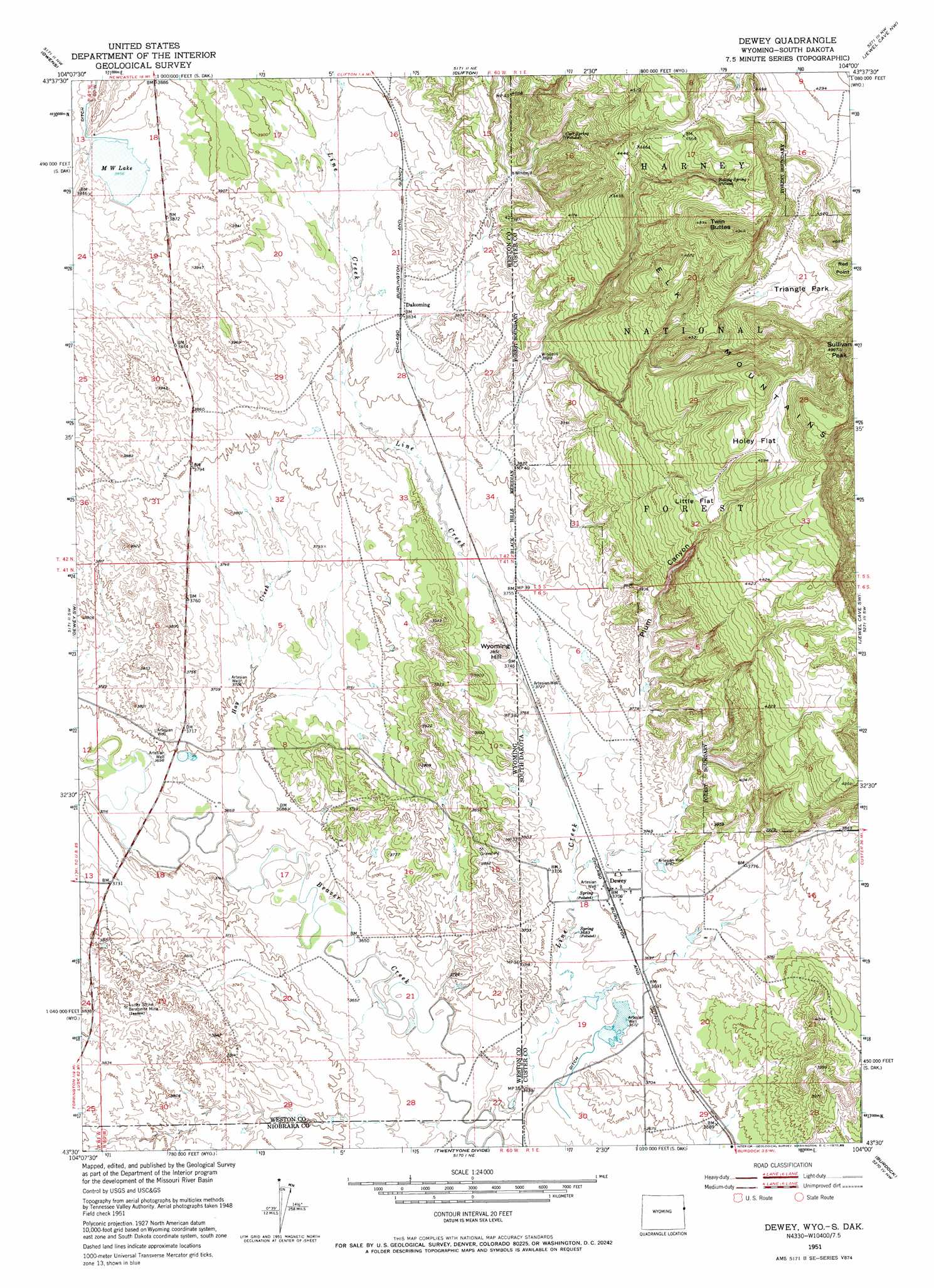
USGS Topo Quad 43104e1 - 1:24,000 scale
| Topo Map Name: | Dewey |
| USGS Topo Quad ID: | 43104e1 |
| Print Size: | ca. 21 1/4" wide x 27" high |
| Southeast Coordinates: | 43.5° N latitude / 104° W longitude |
| Map Center Coordinates: | 43.5625° N latitude / 104.0625° W longitude |
| U.S. States: | WY, SD |
| Filename: | o43104e1.jpg |
| Download Map JPG Image: | Dewey topo map 1:24,000 scale |
| Map Type: | Topographic |
| Topo Series: | 7.5´ |
| Map Scale: | 1:24,000 |
| Source of Map Images: | United States Geological Survey (USGS) |
| Alternate Map Versions: |
Dewey SD 1951, updated 1953 Download PDF Buy paper map Dewey SD 1951, updated 1970 Download PDF Buy paper map Dewey SD 1951, updated 1985 Download PDF Buy paper map Dewey SD 1951, updated 1985 Download PDF Buy paper map Dewey SD 2012 Download PDF Buy paper map Dewey SD 2015 Download PDF Buy paper map |
| FStopo: | US Forest Service topo Dewey is available: Download FStopo PDF Download FStopo TIF |
1:24,000 Topo Quads surrounding Dewey
Osage Se |
Newcastle |
Fanny Peak |
Dead Horse Flats |
Signal Hill |
Morrisey Ne |
Owens |
Clifton |
Jewel Cave Nw |
Jewel Cave |
Morrisey Se |
Dewey Sw |
Dewey |
Jewel Cave Sw |
Jewel Cave Se |
Little Alkali Creek |
Riverview |
Twentyone Divide |
Burdock |
Edgemont Ne |
Bowen Flat |
Mule Creek |
Mule Creek Se |
Edgemont Sw |
Edgemont |
> Back to 43104e1 at 1:100,000 scale
> Back to 43104a1 at 1:250,000 scale
> Back to U.S. Topo Maps home
Dewey topo map: Gazetteer
Dewey: Flats
Holey Flat elevation 1384m 4540′Little Flat elevation 1338m 4389′
Triangle Park elevation 1366m 4481′
Dewey: Lakes
M W Lake elevation 1176m 3858′Dewey: Mines
Elk Mountain Mine elevation 1181m 3874′Lucky Strike Bentonite Mine elevation 1159m 3802′
Wicker and Baldwin Mine elevation 1185m 3887′
Dewey: Populated Places
Dakoming elevation 1170m 3838′Dewey elevation 1132m 3713′
Dewey: Springs
Baltzly Spring elevation 1372m 4501′Carr Spring elevation 1237m 4058′
Dewey: Streams
Hay Creek elevation 1116m 3661′Line Creek elevation 1105m 3625′
Line Creek elevation 1105m 3625′
Dewey: Summits
Red Point elevation 1428m 4685′Sullivan Peak elevation 1507m 4944′
Twin Buttes elevation 1508m 4947′
Wyoming Hill elevation 1173m 3848′
Dewey: Valleys
Plum Canyon elevation 1134m 3720′Dewey digital topo map on disk
Buy this Dewey topo map showing relief, roads, GPS coordinates and other geographical features, as a high-resolution digital map file on DVD:
Eastern Wyoming & Western South Dakota
Buy digital topo maps: Eastern Wyoming & Western South Dakota