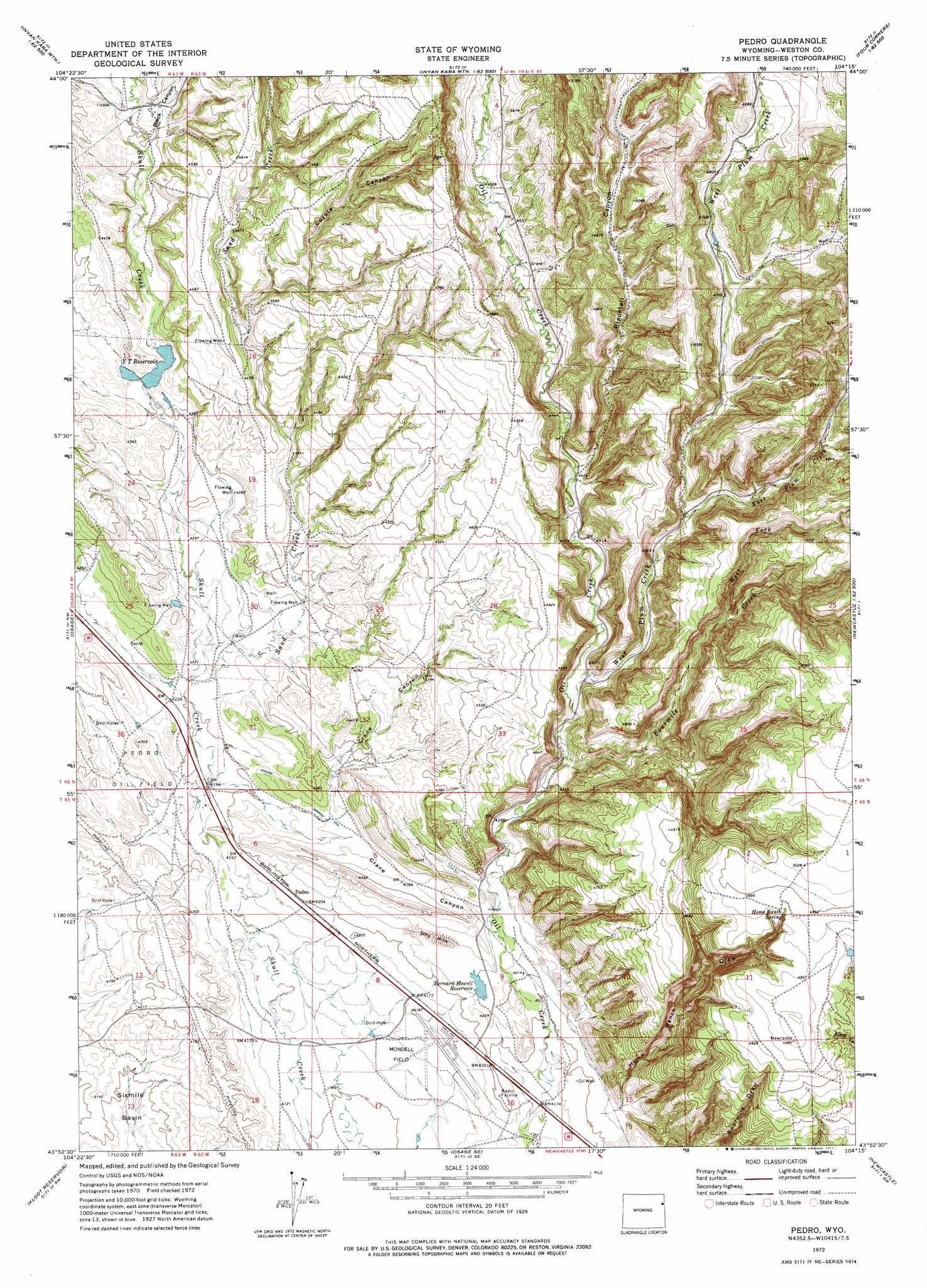
Pedro Topo Map Wyoming
To zoom in, hover over the map of Pedro
USGS Topo Quad 43104h3 - 1:24,000 scale
| Topo Map Name: | Pedro |
| USGS Topo Quad ID: | 43104h3 |
| Print Size: | ca. 21 1/4" wide x 27" high |
| Southeast Coordinates: | 43.875° N latitude / 104.25° W longitude |
| Map Center Coordinates: | 43.9375° N latitude / 104.3125° W longitude |
| U.S. State: | WY |
| Filename: | o43104h3.jpg |
| Download Map JPG Image: | Pedro topo map 1:24,000 scale |
| Map Type: | Topographic |
| Topo Series: | 7.5´ |
| Map Scale: | 1:24,000 |
| Source of Map Images: | United States Geological Survey (USGS) |
| Alternate Map Versions: |
Pedro WY 1972, updated 1977 Download PDF Buy paper map Pedro WY 2012 Download PDF Buy paper map Pedro WY 2015 Download PDF Buy paper map |
| FStopo: | US Forest Service topo Pedro is available: Download FStopo PDF Download FStopo TIF |
1:24,000 Topo Quads surrounding Pedro
Arrowhead Reservoir |
Sheldon Creek |
Inyan Kara Mountain |
Dry Draw |
Buckhorn |
Upton East |
Clay Spur |
Skull Creek |
Four Corners |
Parmlee Canyon |
Sheep Canyon Creek East |
Osage |
Pedro |
Cambria |
Moon |
Lassen Creek |
Klodt Reservoir |
Osage Se |
Newcastle |
Fanny Peak |
Dupont Creek |
Timber Creek |
Morrisey Ne |
Owens |
Clifton |
> Back to 43104e1 at 1:100,000 scale
> Back to 43104a1 at 1:250,000 scale
> Back to U.S. Topo Maps home
Pedro topo map: Gazetteer
Pedro: Airports
Mondell Field elevation 1263m 4143′Pedro: Dams
Enlargement Baird Number 2 Dam elevation 1330m 4363′Enlargement J L Baird Number 1 Dam elevation 1327m 4353′
Mary Ellen Dam elevation 1285m 4215′
Pedro: Oilfields
Pedro Oil Field elevation 1294m 4245′Pedro: Reservoirs
Bernard Howell Reservoir elevation 1288m 4225′Enlargement Baird Number 2 Reservoir elevation 1330m 4363′
Enlargement J L Baird Number 1 Reservoir elevation 1327m 4353′
Mary Ellen Reservoir elevation 1285m 4215′
Y T Reservoir elevation 1316m 4317′
Pedro: Springs
Home Ranch Spring elevation 1514m 4967′Pedro: Streams
East Plum Creek elevation 1370m 4494′Fourmile Creek elevation 1310m 4297′
Sand Creek elevation 1282m 4206′
West Fork Fourmile Creek elevation 1396m 4580′
West Plum Creek elevation 1321m 4333′
Pedro: Valleys
Black Canyon elevation 1341m 4399′Blacktail Canyon elevation 1353m 4438′
Coyote Canyon elevation 1376m 4514′
Crane Canyon elevation 1293m 4242′
Home Ranch Draw elevation 1286m 4219′
Pedro digital topo map on disk
Buy this Pedro topo map showing relief, roads, GPS coordinates and other geographical features, as a high-resolution digital map file on DVD:
Eastern Wyoming & Western South Dakota
Buy digital topo maps: Eastern Wyoming & Western South Dakota