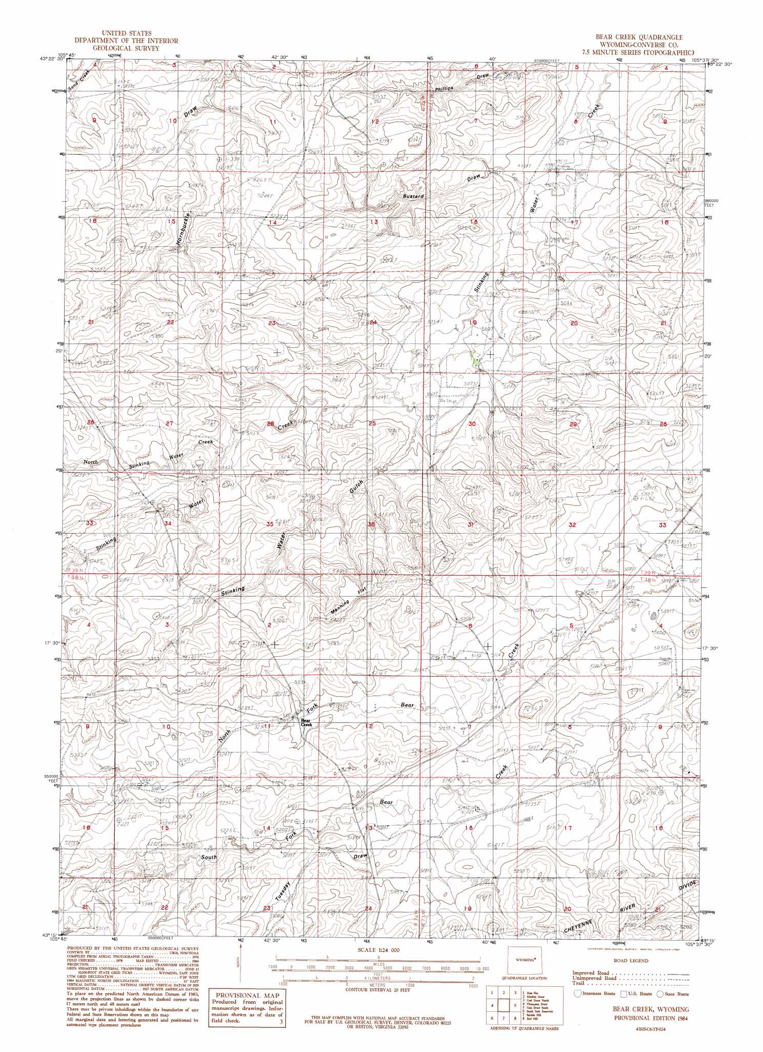
Bear Creek Topo Map Wyoming
To zoom in, hover over the map of Bear Creek
USGS Topo Quad 43105c6 - 1:24,000 scale
| Topo Map Name: | Bear Creek |
| USGS Topo Quad ID: | 43105c6 |
| Print Size: | ca. 21 1/4" wide x 27" high |
| Southeast Coordinates: | 43.25° N latitude / 105.625° W longitude |
| Map Center Coordinates: | 43.3125° N latitude / 105.6875° W longitude |
| U.S. State: | WY |
| Filename: | o43105c6.jpg |
| Download Map JPG Image: | Bear Creek topo map 1:24,000 scale |
| Map Type: | Topographic |
| Topo Series: | 7.5´ |
| Map Scale: | 1:24,000 |
| Source of Map Images: | United States Geological Survey (USGS) |
| Alternate Map Versions: |
Bear Creek WY 1984, updated 1984 Download PDF Buy paper map Bear Creek WY 2012 Download PDF Buy paper map Bear Creek WY 2015 Download PDF Buy paper map |
| FStopo: | US Forest Service topo Bear Creek is available: Download FStopo PDF Download FStopo TIF |
1:24,000 Topo Quads surrounding Bear Creek
Artesian Draw |
Pine Tree |
Turnercrest |
Reno Flats |
Teckla Sw |
Ross |
Ross Flat |
Macken Draw |
Coal Draw North |
Betty Reservoir |
Marsh Draw |
Thompson Draw |
Bear Creek |
Coal Draw South |
Alta Creek |
Fly Draw |
South Fork Reservoir |
Suicide Hill |
Red Hill |
Patsy Draw |
Gumbo Hill |
Coal Hill |
Holdup Hollow |
Whipple Hollow |
Bobby Draw |
> Back to 43105a1 at 1:100,000 scale
> Back to 43104a1 at 1:250,000 scale
> Back to U.S. Topo Maps home
Bear Creek topo map: Gazetteer
Bear Creek: Airports
Hardy Ranch Airport elevation 1549m 5082′Bear Creek: Dams
Hardy Number 1 Dam elevation 1544m 5065′Seepage Control Dam elevation 1557m 5108′
Tailings Disposal Dam elevation 1594m 5229′
Bear Creek: Flats
Manning Flat elevation 1648m 5406′Bear Creek: Reservoirs
Hardy Number 1 Reservoir elevation 1544m 5065′Seepage Control Reservoir elevation 1557m 5108′
Tailings Disposal Reservoir elevation 1594m 5229′
Bear Creek: Streams
North Stinking Water Creek elevation 1565m 5134′Bear Creek: Valleys
Bustard Draw elevation 1513m 4963′Hornbuckle Draw elevation 1557m 5108′
Stinking Water Gulch elevation 1543m 5062′
Bear Creek digital topo map on disk
Buy this Bear Creek topo map showing relief, roads, GPS coordinates and other geographical features, as a high-resolution digital map file on DVD:
Eastern Wyoming & Western South Dakota
Buy digital topo maps: Eastern Wyoming & Western South Dakota