Rolling Pin Ranch Topo Map Wyoming
To zoom in, hover over the map of Rolling Pin Ranch
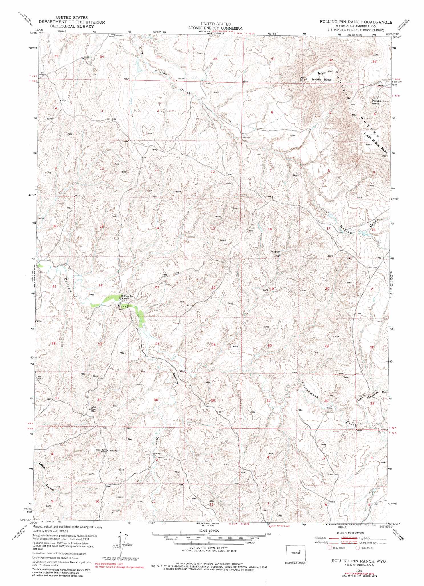
USGS Topo Quad 43105f8 - 1:24,000 scale
| Topo Map Name: | Rolling Pin Ranch |
| USGS Topo Quad ID: | 43105f8 |
| Print Size: | ca. 21 1/4" wide x 27" high |
| Southeast Coordinates: | 43.625° N latitude / 105.875° W longitude |
| Map Center Coordinates: | 43.6875° N latitude / 105.9375° W longitude |
| U.S. State: | WY |
| Filename: | o43105f8.jpg |
| Download Map JPG Image: | Rolling Pin Ranch topo map 1:24,000 scale |
| Map Type: | Topographic |
| Topo Series: | 7.5´ |
| Map Scale: | 1:24,000 |
| Source of Map Images: | United States Geological Survey (USGS) |
| Alternate Map Versions: |
Rolling Pin Ranch WY 1953, updated 1954 Download PDF Buy paper map Rolling Pin Ranch WY 1953, updated 1970 Download PDF Buy paper map Rolling Pin Ranch WY 1953, updated 1980 Download PDF Buy paper map Rolling Pin Ranch WY 2012 Download PDF Buy paper map Rolling Pin Ranch WY 2015 Download PDF Buy paper map |
1:24,000 Topo Quads surrounding Rolling Pin Ranch
Hoe Ranch |
The Nipple |
Fats Draw |
Wags Pinnacle |
Pepsson Draw |
Fort Reno |
Fort Reno Se |
North Butte |
Savageton |
Greasewood Reservoir |
House Creek |
Dry Fork Ranch |
Rolling Pin Ranch |
South Butte |
Baker Spring |
Linch |
Taylor Ranch |
Artesian Draw |
Pine Tree |
Turnercrest |
Edgerton |
Sawmill Canyon |
Ross |
Ross Flat |
Macken Draw |
> Back to 43105e1 at 1:100,000 scale
> Back to 43104a1 at 1:250,000 scale
> Back to U.S. Topo Maps home
Rolling Pin Ranch topo map: Gazetteer
Rolling Pin Ranch: Dams
Brown Dam elevation 1509m 4950′Rolling Pin Ranch: Reservoirs
Brown Reservoir elevation 1509m 4950′Rolling Pin Ranch: Streams
North Cottonwood Creek elevation 1529m 5016′Rolling Pin Ranch: Summits
North Middle Butte elevation 1832m 6010′Rolling Pin Ranch: Valleys
Collins Draw elevation 1457m 4780′Rolling Pin Ranch digital topo map on disk
Buy this Rolling Pin Ranch topo map showing relief, roads, GPS coordinates and other geographical features, as a high-resolution digital map file on DVD:
Eastern Wyoming & Western South Dakota
Buy digital topo maps: Eastern Wyoming & Western South Dakota