North Butte Topo Map Wyoming
To zoom in, hover over the map of North Butte
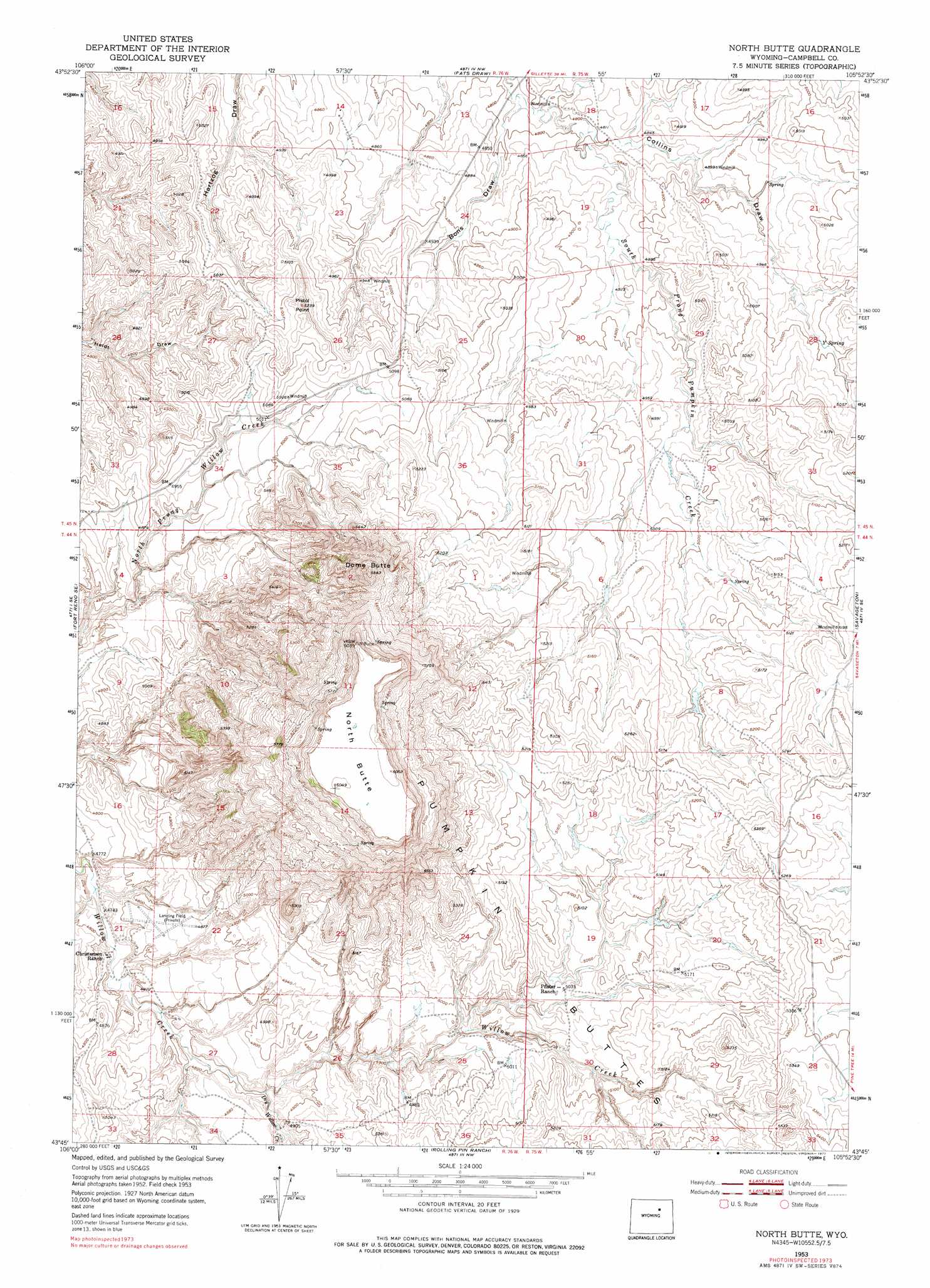
USGS Topo Quad 43105g8 - 1:24,000 scale
| Topo Map Name: | North Butte |
| USGS Topo Quad ID: | 43105g8 |
| Print Size: | ca. 21 1/4" wide x 27" high |
| Southeast Coordinates: | 43.75° N latitude / 105.875° W longitude |
| Map Center Coordinates: | 43.8125° N latitude / 105.9375° W longitude |
| U.S. State: | WY |
| Filename: | o43105g8.jpg |
| Download Map JPG Image: | North Butte topo map 1:24,000 scale |
| Map Type: | Topographic |
| Topo Series: | 7.5´ |
| Map Scale: | 1:24,000 |
| Source of Map Images: | United States Geological Survey (USGS) |
| Alternate Map Versions: |
North Butte WY 1953, updated 1954 Download PDF Buy paper map North Butte WY 1953, updated 1977 Download PDF Buy paper map North Butte WY 2012 Download PDF Buy paper map North Butte WY 2015 Download PDF Buy paper map |
1:24,000 Topo Quads surrounding North Butte
Bowman Flat |
Negro Butte |
Bogie Draw |
Double Tanks |
Pleasantdale |
Hoe Ranch |
The Nipple |
Fats Draw |
Wags Pinnacle |
Pepsson Draw |
Fort Reno |
Fort Reno Se |
North Butte |
Savageton |
Greasewood Reservoir |
House Creek |
Dry Fork Ranch |
Rolling Pin Ranch |
South Butte |
Baker Spring |
Linch |
Taylor Ranch |
Artesian Draw |
Pine Tree |
Turnercrest |
> Back to 43105e1 at 1:100,000 scale
> Back to 43104a1 at 1:250,000 scale
> Back to U.S. Topo Maps home
North Butte topo map: Gazetteer
North Butte: Dams
Dresher Dam elevation 1546m 5072′Rodabaugh Dam elevation 1480m 4855′
North Butte: Mines
Bar None Number Forty Claim elevation 1491m 4891′Bashawn Mine elevation 1528m 5013′
Camp Number One Claim elevation 1629m 5344′
Christensen Brothers Ranch Mine elevation 1482m 4862′
Discovery Roll Mine elevation 1558m 5111′
Dome Butte Mine elevation 1596m 5236′
Hawley Numbers One-thirty-two Claims elevation 1500m 4921′
Kerr-McGee Ed Claims Mine elevation 1522m 4993′
Kerr-McGee Jim Claim Mine elevation 1518m 4980′
Kerr-McGee School Lease Mine elevation 1458m 4783′
Lucky Eight Mine elevation 1568m 5144′
Quigley and Gall Claims elevation 1503m 4931′
Quigley and Gall Colorado Number One Mine elevation 1543m 5062′
Simmons Number Two Mine elevation 1535m 5036′
North Butte: Reservoirs
Dresher Reservoir elevation 1546m 5072′Rodabaugh Reservoir elevation 1480m 4855′
North Butte: Springs
Y Spring elevation 1528m 5013′North Butte: Streams
Dry Willow Creek elevation 1462m 4796′North Butte: Summits
Dome Butte elevation 1718m 5636′North Butte elevation 1842m 6043′
Pistol Point elevation 1537m 5042′
North Butte: Valleys
Bons Draw elevation 1455m 4773′Collins Draw elevation 1466m 4809′
North Butte digital topo map on disk
Buy this North Butte topo map showing relief, roads, GPS coordinates and other geographical features, as a high-resolution digital map file on DVD:
Eastern Wyoming & Western South Dakota
Buy digital topo maps: Eastern Wyoming & Western South Dakota