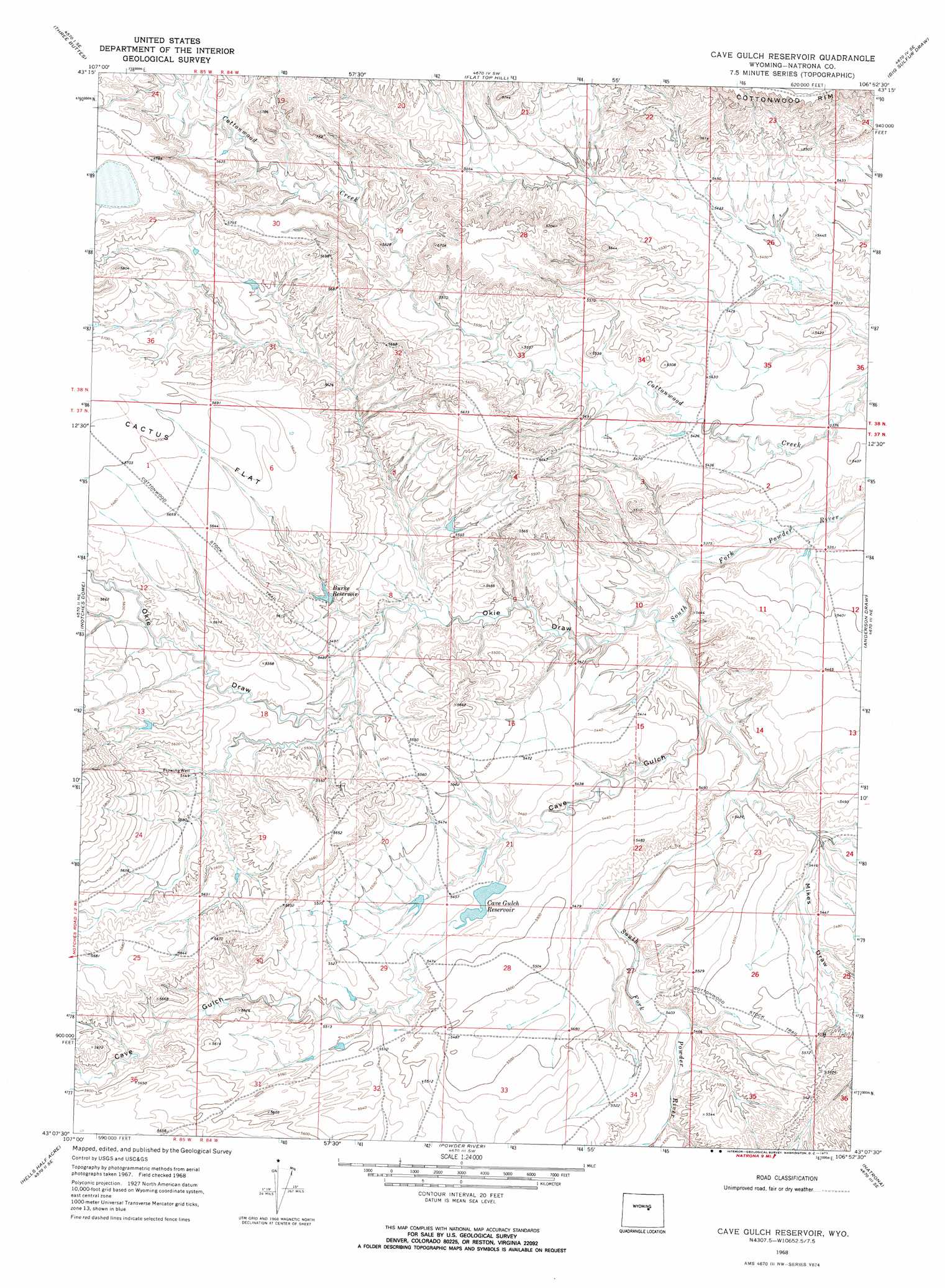
Cave Gulch Reservoir Topo Map Wyoming
To zoom in, hover over the map of Cave Gulch Reservoir
USGS Topo Quad 43106b8 - 1:24,000 scale
| Topo Map Name: | Cave Gulch Reservoir |
| USGS Topo Quad ID: | 43106b8 |
| Print Size: | ca. 21 1/4" wide x 27" high |
| Southeast Coordinates: | 43.125° N latitude / 106.875° W longitude |
| Map Center Coordinates: | 43.1875° N latitude / 106.9375° W longitude |
| U.S. State: | WY |
| Filename: | o43106b8.jpg |
| Download Map JPG Image: | Cave Gulch Reservoir topo map 1:24,000 scale |
| Map Type: | Topographic |
| Topo Series: | 7.5´ |
| Map Scale: | 1:24,000 |
| Source of Map Images: | United States Geological Survey (USGS) |
| Alternate Map Versions: |
Cave Gulch Reservoir WY 1968, updated 1973 Download PDF Buy paper map Cave Gulch Reservoir WY 2012 Download PDF Buy paper map Cave Gulch Reservoir WY 2015 Download PDF Buy paper map |
1:24,000 Topo Quads surrounding Cave Gulch Reservoir
Grave Spring |
First Water Draw |
Roughlock Hill |
Willow Creek School |
Broken Horn Creek |
Deadman Butte |
Three Buttes |
Flat Top Hill |
Big Sulfur Draw |
Fiftymile Flat |
Waltman Nw |
Notches Dome |
Cave Gulch Reservoir |
Anderson Draw |
Reynolds Reservoir |
Waltman |
Hells Half Acre |
Powder River |
Natrona |
Burlington Lake |
Broad Mesa |
Gaylord Reservoir |
Square Top Butte |
Reid Canyon |
Emigrant Gap Nw |
> Back to 43106a1 at 1:100,000 scale
> Back to 43106a1 at 1:250,000 scale
> Back to U.S. Topo Maps home
Cave Gulch Reservoir topo map: Gazetteer
Cave Gulch Reservoir: Dams
Cave Gulch Dam elevation 1665m 5462′Metcalf Dam elevation 1725m 5659′
Sutterfield Dam elevation 1707m 5600′
Cave Gulch Reservoir: Flats
Cactus Flat elevation 1735m 5692′Cave Gulch Reservoir: Reservoirs
Burke Reservoir elevation 1672m 5485′Cave Gulch Reservoir elevation 1665m 5462′
Cave Gulch Reservoir elevation 1660m 5446′
Metcalf Reservoir elevation 1725m 5659′
Sutterfield Reservoir elevation 1707m 5600′
Cave Gulch Reservoir: Valleys
Cave Gulch elevation 1635m 5364′Mikes Draw elevation 1639m 5377′
Okie Draw elevation 1628m 5341′
Cave Gulch Reservoir digital topo map on disk
Buy this Cave Gulch Reservoir topo map showing relief, roads, GPS coordinates and other geographical features, as a high-resolution digital map file on DVD:
Eastern Wyoming & Western South Dakota
Buy digital topo maps: Eastern Wyoming & Western South Dakota