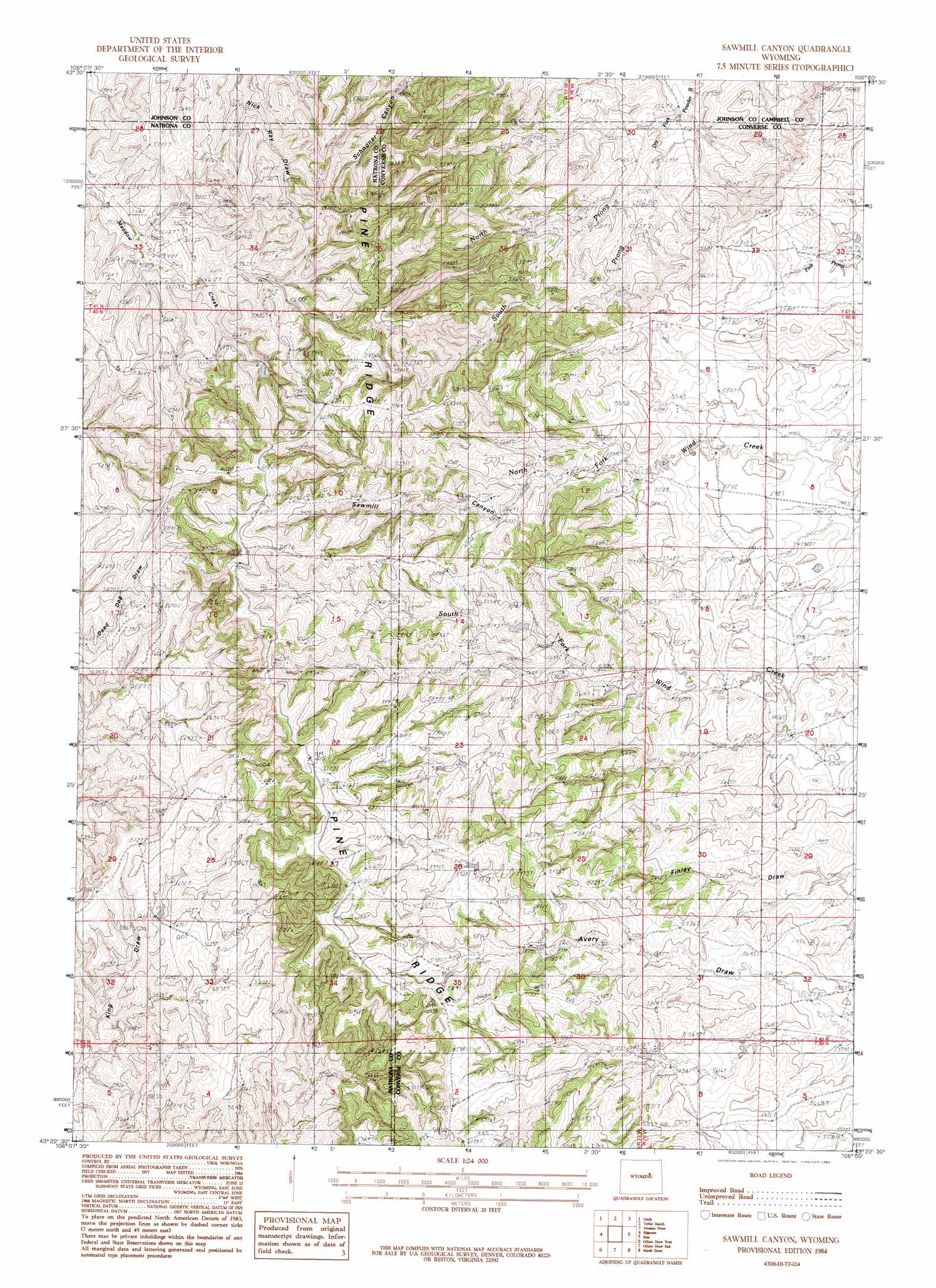
Sawmill Canyon Topo Map Wyoming
To zoom in, hover over the map of Sawmill Canyon
USGS Topo Quad 43106d1 - 1:24,000 scale
| Topo Map Name: | Sawmill Canyon |
| USGS Topo Quad ID: | 43106d1 |
| Print Size: | ca. 21 1/4" wide x 27" high |
| Southeast Coordinates: | 43.375° N latitude / 106° W longitude |
| Map Center Coordinates: | 43.4375° N latitude / 106.0625° W longitude |
| U.S. State: | WY |
| Filename: | o43106d1.jpg |
| Download Map JPG Image: | Sawmill Canyon topo map 1:24,000 scale |
| Map Type: | Topographic |
| Topo Series: | 7.5´ |
| Map Scale: | 1:24,000 |
| Source of Map Images: | United States Geological Survey (USGS) |
| Alternate Map Versions: |
Sawmill Canyon WY 1984, updated 1984 Download PDF Buy paper map Sawmill Canyon WY 2012 Download PDF Buy paper map Sawmill Canyon WY 2015 Download PDF Buy paper map |
1:24,000 Topo Quads surrounding Sawmill Canyon
Sussex |
House Creek |
Dry Fork Ranch |
Rolling Pin Ranch |
South Butte |
Dead Woman Crossing |
Linch |
Taylor Ranch |
Artesian Draw |
Pine Tree |
Midwest |
Edgerton |
Sawmill Canyon |
Ross |
Ross Flat |
Salt Creek |
Gillam Draw West |
Gillam Draw East |
Marsh Draw |
Thompson Draw |
Teapot Rock |
Seven L Creek West |
Seven L Creek East |
Fly Draw |
South Fork Reservoir |
> Back to 43106a1 at 1:100,000 scale
> Back to 43106a1 at 1:250,000 scale
> Back to U.S. Topo Maps home
Sawmill Canyon topo map: Gazetteer
Sawmill Canyon: Dams
Gafford Dam elevation 1745m 5725′Sawmill Canyon: Mines
Baker Numbers Three-five Mine elevation 1661m 5449′Sawmill Canyon: Oilfields
Sherwood Oil Field elevation 1859m 6099′Sawmill Canyon: Reservoirs
Gafford Reservoir elevation 1745m 5725′Sawmill Canyon: Ridges
Pine Ridge elevation 1840m 6036′Sawmill Canyon: Streams
North Prong Dry Fork Powder River elevation 1616m 5301′South Prong Dry Fork Powder River elevation 1616m 5301′
Sawmill Canyon: Valleys
Sawmill Canyon elevation 1721m 5646′Sawmill Canyon digital topo map on disk
Buy this Sawmill Canyon topo map showing relief, roads, GPS coordinates and other geographical features, as a high-resolution digital map file on DVD:
Eastern Wyoming & Western South Dakota
Buy digital topo maps: Eastern Wyoming & Western South Dakota