Kaycee Ne Topo Map Wyoming
To zoom in, hover over the map of Kaycee Ne
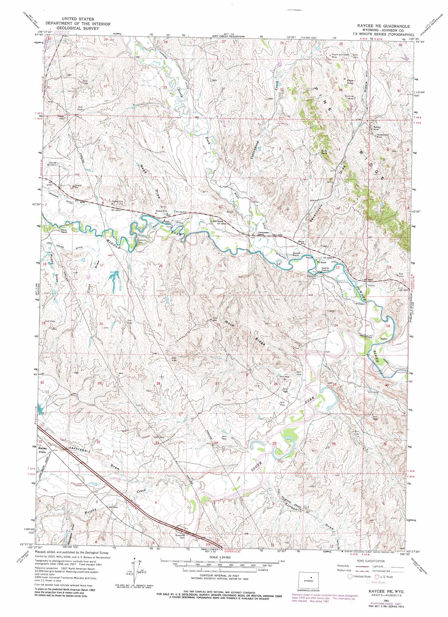
USGS Topo Quad 43106f5 - 1:24,000 scale
| Topo Map Name: | Kaycee Ne |
| USGS Topo Quad ID: | 43106f5 |
| Print Size: | ca. 21 1/4" wide x 27" high |
| Southeast Coordinates: | 43.625° N latitude / 106.5° W longitude |
| Map Center Coordinates: | 43.6875° N latitude / 106.5625° W longitude |
| U.S. State: | WY |
| Filename: | o43106f5.jpg |
| Download Map JPG Image: | Kaycee Ne topo map 1:24,000 scale |
| Map Type: | Topographic |
| Topo Series: | 7.5´ |
| Map Scale: | 1:24,000 |
| Source of Map Images: | United States Geological Survey (USGS) |
| Alternate Map Versions: |
Kaycee NE WY 1961, updated 1964 Download PDF Buy paper map Kaycee NE WY 1961, updated 1978 Download PDF Buy paper map Kaycee NE WY 1961, updated 1982 Download PDF Buy paper map Kaycee NE WY 2012 Download PDF Buy paper map Kaycee NE WY 2015 Download PDF Buy paper map |
1:24,000 Topo Quads surrounding Kaycee Ne
The Horn |
Schlicht Draw |
Antelope Draw |
Elaine Draw |
Provence Ranch |
Mayoworth |
Hibbard Draw |
Dry Creek Reservoir |
Fourmile Reservoir |
Soldier Creek |
Red Fork Powder River |
Kaycee |
Kaycee Ne |
Figure 8 Reservoir |
Sussex |
Hole-In-The-Wall |
T T T Ranch |
Wall Creek |
Dugout Ranch |
Dead Woman Crossing |
Willow Creek School |
Broken Horn Creek |
Salt Canyon |
Government Creek |
Midwest |
> Back to 43106e1 at 1:100,000 scale
> Back to 43106a1 at 1:250,000 scale
> Back to U.S. Topo Maps home
Kaycee Ne topo map: Gazetteer
Kaycee Ne: Canals
Jarrard Ditch elevation 1427m 4681′John Nolen Ditch elevation 1420m 4658′
Miles Ditch elevation 1402m 4599′
Modoc Ditch elevation 1399m 4589′
Newland Ditch elevation 1390m 4560′
Kaycee Ne: Dams
Applegate Dam elevation 1458m 4783′N Jack Rabbit Dam elevation 1446m 4744′
Kaycee Ne: Mines
Babion Mine elevation 1472m 4829′Bunning Mine elevation 1474m 4835′
Bybee Mines elevation 1482m 4862′
Christensen Mine elevation 1469m 4819′
Christenson Mine elevation 1471m 4826′
Jarrard Extension Mine elevation 1419m 4655′
Jarrard Rock Pile Mine elevation 1422m 4665′
Schiffer Mine elevation 1397m 4583′
Sipple and Smith Mine elevation 1474m 4835′
Ullery Mine elevation 1463m 4799′
Kaycee Ne: Reservoirs
Applegate Reservoir elevation 1458m 4783′N Jack Rabbit Reservoir elevation 1446m 4744′
Kaycee Ne: Ridges
Rock Ridge elevation 1468m 4816′Kaycee Ne: Slopes
Sipple Hill elevation 1484m 4868′Kaycee Ne: Streams
Cottonwood Creek elevation 1394m 4573′Middle Fork Powder River elevation 1391m 4563′
Murphy Creek elevation 1396m 4580′
North Fork Powder River elevation 1391m 4563′
South Fork Powder River elevation 1379m 4524′
Kaycee Ne: Valleys
Applegate Draw elevation 1425m 4675′Ellison Draw elevation 1392m 4566′
Flynn Draw elevation 1412m 4632′
Jackrabbit Draw elevation 1407m 4616′
Muddy Draw elevation 1419m 4655′
Read Draw elevation 1401m 4596′
Seventysix Draw elevation 1394m 4573′
Terry Draw elevation 1409m 4622′
Kaycee Ne digital topo map on disk
Buy this Kaycee Ne topo map showing relief, roads, GPS coordinates and other geographical features, as a high-resolution digital map file on DVD:
Eastern Wyoming & Western South Dakota
Buy digital topo maps: Eastern Wyoming & Western South Dakota