Hibbard Draw Topo Map Wyoming
To zoom in, hover over the map of Hibbard Draw
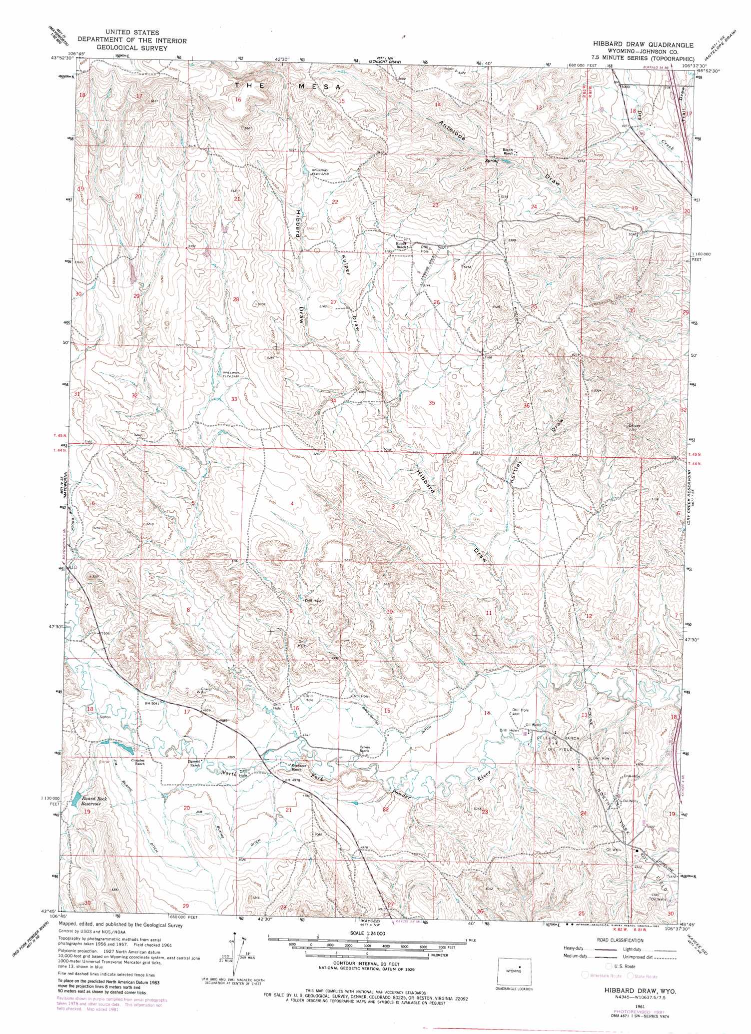
USGS Topo Quad 43106g6 - 1:24,000 scale
| Topo Map Name: | Hibbard Draw |
| USGS Topo Quad ID: | 43106g6 |
| Print Size: | ca. 21 1/4" wide x 27" high |
| Southeast Coordinates: | 43.75° N latitude / 106.625° W longitude |
| Map Center Coordinates: | 43.8125° N latitude / 106.6875° W longitude |
| U.S. State: | WY |
| Filename: | o43106g6.jpg |
| Download Map JPG Image: | Hibbard Draw topo map 1:24,000 scale |
| Map Type: | Topographic |
| Topo Series: | 7.5´ |
| Map Scale: | 1:24,000 |
| Source of Map Images: | United States Geological Survey (USGS) |
| Alternate Map Versions: |
Hibbard Draw WY 1961, updated 1965 Download PDF Buy paper map Hibbard Draw WY 1961, updated 1982 Download PDF Buy paper map Hibbard Draw WY 2012 Download PDF Buy paper map Hibbard Draw WY 2015 Download PDF Buy paper map |
1:24,000 Topo Quads surrounding Hibbard Draw
Hazelton |
Robinson Canyon |
Purdy Reservoir |
Trabing |
Brown Ranch |
Packsaddle Canyon |
The Horn |
Schlicht Draw |
Antelope Draw |
Elaine Draw |
Fraker Mountain |
Mayoworth |
Hibbard Draw |
Dry Creek Reservoir |
Fourmile Reservoir |
Barnum |
Red Fork Powder River |
Kaycee |
Kaycee Ne |
Figure 8 Reservoir |
Poker Butte |
Hole-In-The-Wall |
T T T Ranch |
Wall Creek |
Dugout Ranch |
> Back to 43106e1 at 1:100,000 scale
> Back to 43106a1 at 1:250,000 scale
> Back to U.S. Topo Maps home
Hibbard Draw topo map: Gazetteer
Hibbard Draw: Canals
Bob Brock Ditch elevation 1568m 5144′Broughton Ditch elevation 1504m 4934′
Jim Blaine Ditch elevation 1536m 5039′
Hibbard Draw: Dams
Pass Creek Dam elevation 1548m 5078′Pass Creek Number 2 Dam elevation 1556m 5104′
Hibbard Draw: Mines
Benton Clay Bentonite Mine elevation 1623m 5324′Cellar Number Four Mine elevation 1548m 5078′
Daniels Pit Number Two Mine elevation 1609m 5278′
Kaycee Bentonite Corporation Number Ninety-seven Mine elevation 1502m 4927′
Kaycee Bentonite Corporation Number One-hundred Mine elevation 1501m 4924′
Mayworth Number Seven and Eight Mine elevation 1486m 4875′
Hibbard Draw: Oilfields
Cellers Ranch Oil Field elevation 1490m 4888′North Fork Oil Field elevation 1500m 4921′
Hibbard Draw: Reservoirs
Hardluck Reservoir elevation 1544m 5065′Pass Creek Number 2 Reservoir elevation 1556m 5104′
Round Rock Reservoir elevation 1556m 5104′
Hibbard Draw: Streams
Pass Creek elevation 1537m 5042′Hibbard Draw: Valleys
Hibbard Draw elevation 1468m 4816′Kuiper Draw elevation 1529m 5016′
Kurtley Draw elevation 1499m 4917′
Hibbard Draw digital topo map on disk
Buy this Hibbard Draw topo map showing relief, roads, GPS coordinates and other geographical features, as a high-resolution digital map file on DVD:
Eastern Wyoming & Western South Dakota
Buy digital topo maps: Eastern Wyoming & Western South Dakota