Hells Half Acre Topo Map Wyoming
To zoom in, hover over the map of Hells Half Acre
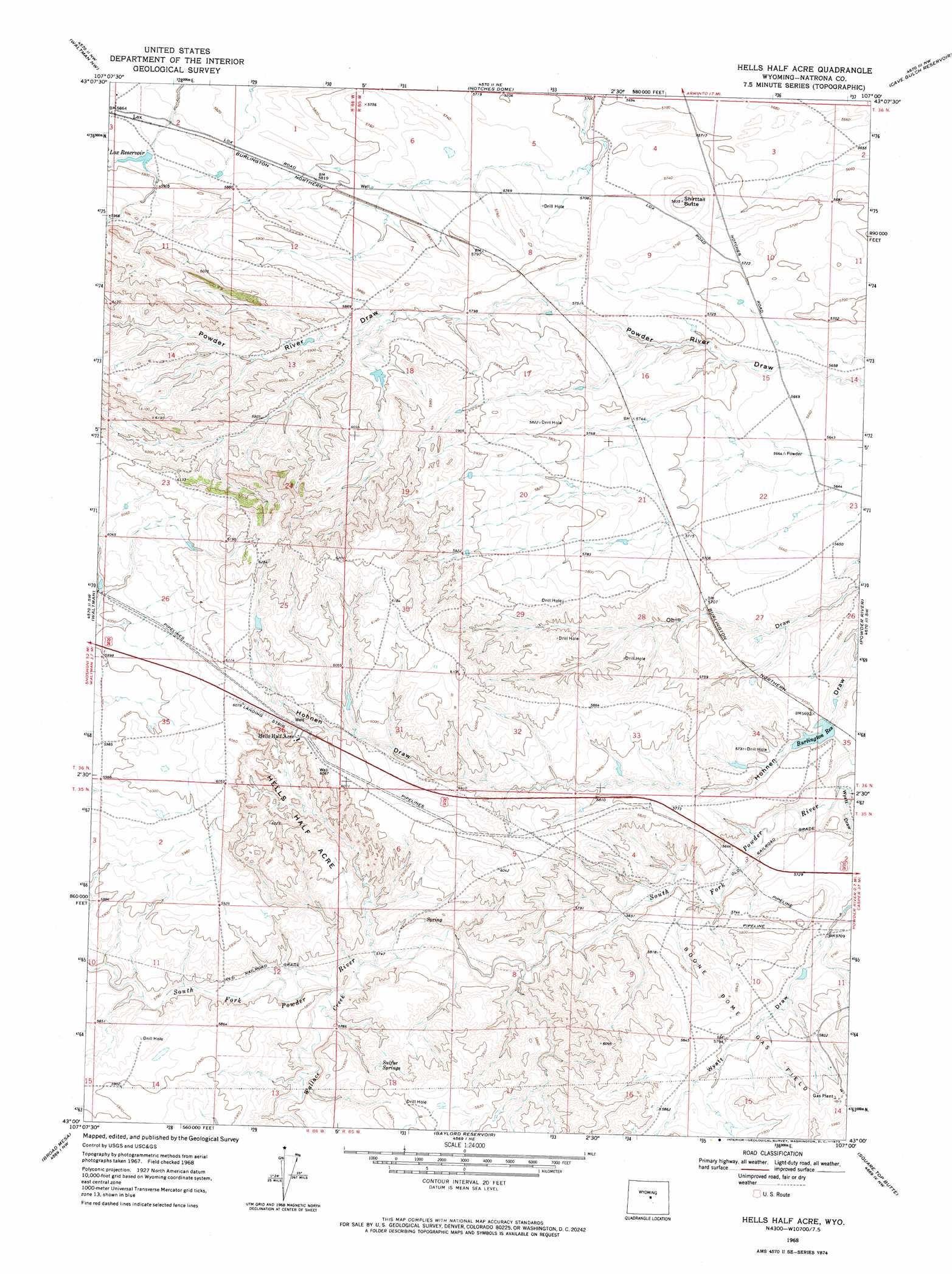
USGS Topo Quad 43107a1 - 1:24,000 scale
| Topo Map Name: | Hells Half Acre |
| USGS Topo Quad ID: | 43107a1 |
| Print Size: | ca. 21 1/4" wide x 27" high |
| Southeast Coordinates: | 43° N latitude / 107° W longitude |
| Map Center Coordinates: | 43.0625° N latitude / 107.0625° W longitude |
| U.S. State: | WY |
| Filename: | o43107a1.jpg |
| Download Map JPG Image: | Hells Half Acre topo map 1:24,000 scale |
| Map Type: | Topographic |
| Topo Series: | 7.5´ |
| Map Scale: | 1:24,000 |
| Source of Map Images: | United States Geological Survey (USGS) |
| Alternate Map Versions: |
Hells Half Acre WY 1968, updated 1973 Download PDF Buy paper map Hells Half Acre WY 2012 Download PDF Buy paper map Hells Half Acre WY 2015 Download PDF Buy paper map |
1:24,000 Topo Quads surrounding Hells Half Acre
Badwater Se |
Deadman Butte |
Three Buttes |
Flat Top Hill |
Big Sulfur Draw |
Arminto |
Waltman Nw |
Notches Dome |
Cave Gulch Reservoir |
Anderson Draw |
Hiland |
Waltman |
Hells Half Acre |
Powder River |
Natrona |
Mcrae Gap |
Broad Mesa |
Gaylord Reservoir |
Square Top Butte |
Reid Canyon |
Garfield Peak |
Stinking Water Creek |
Eightmile Draw |
Pine Mountain Sw |
Poison Spider |
> Back to 43107a1 at 1:100,000 scale
> Back to 43106a1 at 1:250,000 scale
> Back to U.S. Topo Maps home
Hells Half Acre topo map: Gazetteer
Hells Half Acre: Dams
Lox Dam elevation 1784m 5853′T E C Dam elevation 1739m 5705′
Hells Half Acre: Oilfields
Boone Dome Gas Field elevation 1776m 5826′Hells Half Acre: Ranges
Hells Half Acre elevation 1791m 5875′Hells Half Acre: Reservoirs
Burlington Reservoir elevation 1724m 5656′Lox Reservoir elevation 1784m 5853′
Lox Reservoir elevation 1788m 5866′
T E C Reservoir elevation 1739m 5705′
Hells Half Acre: Springs
Sulfur Springs elevation 1781m 5843′Hells Half Acre: Streams
Wallace Creek elevation 1745m 5725′Hells Half Acre: Summits
Shirttail Butte elevation 1772m 5813′Hells Half Acre: Valleys
Wyatt Draw elevation 1708m 5603′Hells Half Acre digital topo map on disk
Buy this Hells Half Acre topo map showing relief, roads, GPS coordinates and other geographical features, as a high-resolution digital map file on DVD:
Eastern Wyoming & Western South Dakota
Buy digital topo maps: Eastern Wyoming & Western South Dakota