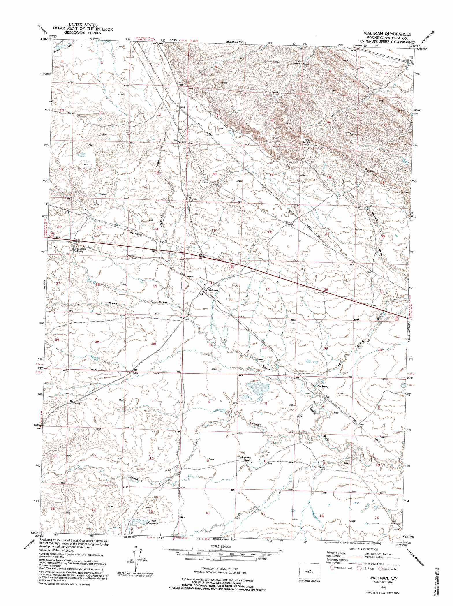
Waltman Topo Map Wyoming
To zoom in, hover over the map of Waltman
USGS Topo Quad 43107a2 - 1:24,000 scale
| Topo Map Name: | Waltman |
| USGS Topo Quad ID: | 43107a2 |
| Print Size: | ca. 21 1/4" wide x 27" high |
| Southeast Coordinates: | 43° N latitude / 107.125° W longitude |
| Map Center Coordinates: | 43.0625° N latitude / 107.1875° W longitude |
| U.S. State: | WY |
| Filename: | o43107a2.jpg |
| Download Map JPG Image: | Waltman topo map 1:24,000 scale |
| Map Type: | Topographic |
| Topo Series: | 7.5´ |
| Map Scale: | 1:24,000 |
| Source of Map Images: | United States Geological Survey (USGS) |
| Alternate Map Versions: |
Waltman WY 1952, updated 1953 Download PDF Buy paper map Waltman WY 1952, updated 1995 Download PDF Buy paper map Waltman WY 2012 Download PDF Buy paper map Waltman WY 2015 Download PDF Buy paper map |
1:24,000 Topo Quads surrounding Waltman
Badwater |
Badwater Se |
Deadman Butte |
Three Buttes |
Flat Top Hill |
Arminto Nw |
Arminto |
Waltman Nw |
Notches Dome |
Cave Gulch Reservoir |
Arminto Sw |
Hiland |
Waltman |
Hells Half Acre |
Powder River |
Ervay Basin |
Mcrae Gap |
Broad Mesa |
Gaylord Reservoir |
Square Top Butte |
Ervay Basin Sw |
Garfield Peak |
Stinking Water Creek |
Eightmile Draw |
Pine Mountain Sw |
> Back to 43107a1 at 1:100,000 scale
> Back to 43106a1 at 1:250,000 scale
> Back to U.S. Topo Maps home
Waltman topo map: Gazetteer
Waltman: Dams
Cooper Dam elevation 1822m 5977′Rochelle Dam elevation 1818m 5964′
Waltman: Mines
Armenta Mine elevation 1812m 5944′Waltman: Populated Places
Waltman elevation 1826m 5990′Waltman: Reservoirs
Cooper Reservoir elevation 1822m 5977′Rochelle Reservoir elevation 1818m 5964′
Waltman: Springs
Keg Spring elevation 1793m 5882′Waltman Spring elevation 1854m 6082′
Waltman: Valleys
Keg Spring Draw elevation 1824m 5984′Sand Draw elevation 1780m 5839′
Waltman Draw elevation 1815m 5954′
Waltman digital topo map on disk
Buy this Waltman topo map showing relief, roads, GPS coordinates and other geographical features, as a high-resolution digital map file on DVD:
Eastern Wyoming & Western South Dakota
Buy digital topo maps: Eastern Wyoming & Western South Dakota