Arminto Topo Map Wyoming
To zoom in, hover over the map of Arminto
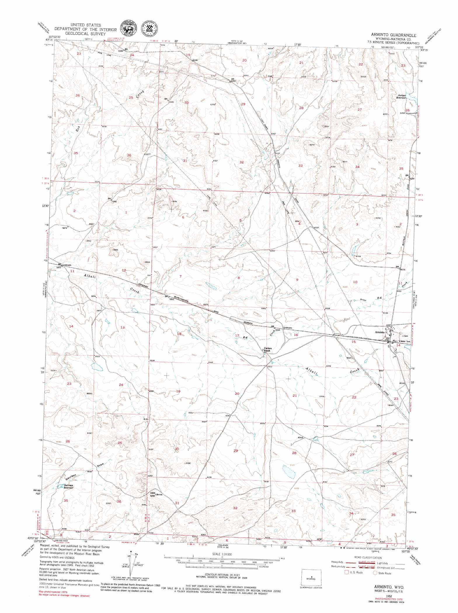
USGS Topo Quad 43107b3 - 1:24,000 scale
| Topo Map Name: | Arminto |
| USGS Topo Quad ID: | 43107b3 |
| Print Size: | ca. 21 1/4" wide x 27" high |
| Southeast Coordinates: | 43.125° N latitude / 107.25° W longitude |
| Map Center Coordinates: | 43.1875° N latitude / 107.3125° W longitude |
| U.S. State: | WY |
| Filename: | o43107b3.jpg |
| Download Map JPG Image: | Arminto topo map 1:24,000 scale |
| Map Type: | Topographic |
| Topo Series: | 7.5´ |
| Map Scale: | 1:24,000 |
| Source of Map Images: | United States Geological Survey (USGS) |
| Alternate Map Versions: |
Arminto WY 1952, updated 1953 Download PDF Buy paper map Arminto WY 1952, updated 1969 Download PDF Buy paper map Arminto WY 1952, updated 1980 Download PDF Buy paper map Arminto WY 2012 Download PDF Buy paper map Arminto WY 2015 Download PDF Buy paper map |
1:24,000 Topo Quads surrounding Arminto
Cottonwood Pass |
Sioux Pass |
Badwater Ne |
Grave Spring |
First Water Draw |
Lysite Se |
Badwater |
Badwater Se |
Deadman Butte |
Three Buttes |
Madden |
Arminto Nw |
Arminto |
Waltman Nw |
Notches Dome |
Moneta Se |
Arminto Sw |
Hiland |
Waltman |
Hells Half Acre |
Miles Ranch |
Ervay Basin |
Mcrae Gap |
Broad Mesa |
Gaylord Reservoir |
> Back to 43107a1 at 1:100,000 scale
> Back to 43106a1 at 1:250,000 scale
> Back to U.S. Topo Maps home
Arminto topo map: Gazetteer
Arminto: Dams
Antelope Dam elevation 1799m 5902′Bad Water Creek Dam elevation 1847m 6059′
Bridge Dam elevation 1799m 5902′
Charlotte Dam elevation 1894m 6213′
Donlin Dam elevation 1832m 6010′
Lynx Dam elevation 1792m 5879′
Red Creek Dam elevation 1871m 6138′
Arminto: Populated Places
Arminto elevation 1845m 6053′Arminto: Reservoirs
Antelope Reservoir elevation 1799m 5902′Bad Water Creek Reservoir elevation 1847m 6059′
Bridge Reservoir elevation 1799m 5902′
Charlotte Reservoir elevation 1894m 6213′
Donlin Reservoir elevation 1832m 6010′
Garrison Reservoir elevation 1825m 5987′
Jackpot Reservoir elevation 1906m 6253′
Lynx Reservoir elevation 1792m 5879′
Red Creek Reservoir elevation 1871m 6138′
Arminto: Streams
E-K Creek elevation 1805m 5921′Arminto digital topo map on disk
Buy this Arminto topo map showing relief, roads, GPS coordinates and other geographical features, as a high-resolution digital map file on DVD:
Eastern Wyoming & Western South Dakota
Buy digital topo maps: Eastern Wyoming & Western South Dakota