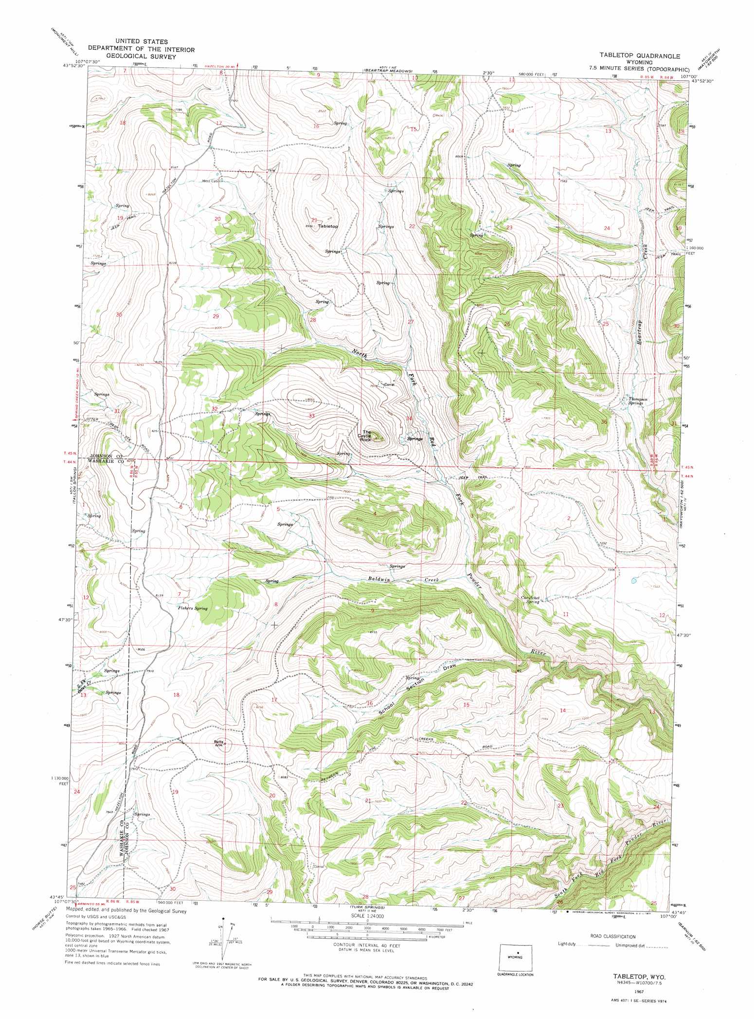
Tabletop Topo Map Wyoming
To zoom in, hover over the map of Tabletop
USGS Topo Quad 43107g1 - 1:24,000 scale
| Topo Map Name: | Tabletop |
| USGS Topo Quad ID: | 43107g1 |
| Print Size: | ca. 21 1/4" wide x 27" high |
| Southeast Coordinates: | 43.75° N latitude / 107° W longitude |
| Map Center Coordinates: | 43.8125° N latitude / 107.0625° W longitude |
| U.S. State: | WY |
| Filename: | o43107g1.jpg |
| Download Map JPG Image: | Tabletop topo map 1:24,000 scale |
| Map Type: | Topographic |
| Topo Series: | 7.5´ |
| Map Scale: | 1:24,000 |
| Source of Map Images: | United States Geological Survey (USGS) |
| Alternate Map Versions: |
Tabletop WY 1967, updated 1971 Download PDF Buy paper map Tabletop WY 2012 Download PDF Buy paper map Tabletop WY 2015 Download PDF Buy paper map |
1:24,000 Topo Quads surrounding Tabletop
Old Maid Gulch |
Onion Gulch |
Hazelton Peak |
Hazelton |
Robinson Canyon |
Big Trails Ne |
Monument Hill |
Beartrap Meadows |
Packsaddle Canyon |
The Horn |
Big Trails |
Tallon Spring |
Tabletop |
Fraker Mountain |
Mayoworth |
Mahogany Butte |
Horse Butte |
Turk Springs |
Barnum |
Red Fork Powder River |
Lost Creek |
Cherry Creek Hill |
Gordon Creek |
Poker Butte |
Hole-In-The-Wall |
> Back to 43107e1 at 1:100,000 scale
> Back to 43106a1 at 1:250,000 scale
> Back to U.S. Topo Maps home
Tabletop topo map: Gazetteer
Tabletop: Mines
Durand Number One Mine elevation 2234m 7329′Durand Number Two Mine elevation 2314m 7591′
Mayworth Number Five Mine elevation 2224m 7296′
Mayworth Number Nine Mine elevation 2207m 7240′
Mayworth Number One Mine elevation 2224m 7296′
Mayworth Number One Mine elevation 2229m 7312′
Mayworth Number Six Mine elevation 2365m 7759′
Slate Ridge Number Eight Mine elevation 2288m 7506′
Slate Ridge Number Nine Mine elevation 2404m 7887′
Slate Ridge Number Ten Mine elevation 2405m 7890′
Tabletop: Springs
Curutchet Spring elevation 2341m 7680′Fishers Spring elevation 2452m 8044′
Thompson Springs elevation 2187m 7175′
Tabletop: Streams
Baldwin Creek elevation 2146m 7040′Tabletop: Summits
Tabletop elevation 2593m 8507′The Castle Rock elevation 2469m 8100′
Tabletop: Valleys
School Section Draw elevation 2113m 6932′Tabletop digital topo map on disk
Buy this Tabletop topo map showing relief, roads, GPS coordinates and other geographical features, as a high-resolution digital map file on DVD:
Eastern Wyoming & Western South Dakota
Buy digital topo maps: Eastern Wyoming & Western South Dakota