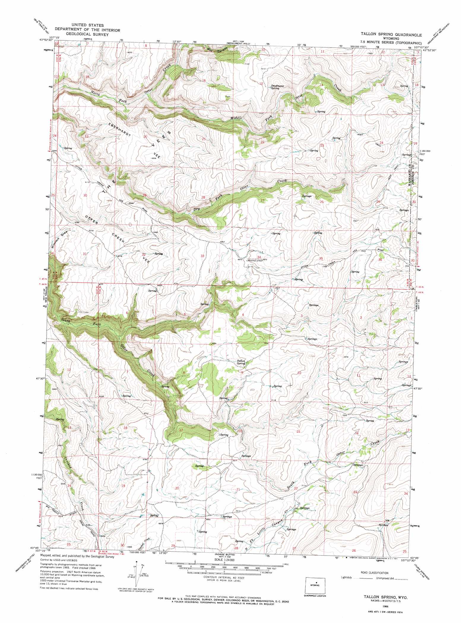
Tallon Spring Topo Map Wyoming
To zoom in, hover over the map of Tallon Spring
USGS Topo Quad 43107g2 - 1:24,000 scale
| Topo Map Name: | Tallon Spring |
| USGS Topo Quad ID: | 43107g2 |
| Print Size: | ca. 21 1/4" wide x 27" high |
| Southeast Coordinates: | 43.75° N latitude / 107.125° W longitude |
| Map Center Coordinates: | 43.8125° N latitude / 107.1875° W longitude |
| U.S. State: | WY |
| Filename: | o43107g2.jpg |
| Download Map JPG Image: | Tallon Spring topo map 1:24,000 scale |
| Map Type: | Topographic |
| Topo Series: | 7.5´ |
| Map Scale: | 1:24,000 |
| Source of Map Images: | United States Geological Survey (USGS) |
| Alternate Map Versions: |
Tallon Spring WY 1966, updated 1971 Download PDF Buy paper map Tallon Spring WY 2012 Download PDF Buy paper map Tallon Spring WY 2015 Download PDF Buy paper map |
1:24,000 Topo Quads surrounding Tallon Spring
Ten Sleep |
Old Maid Gulch |
Onion Gulch |
Hazelton Peak |
Hazelton |
Joe Emge Creek |
Big Trails Ne |
Monument Hill |
Beartrap Meadows |
Packsaddle Canyon |
Indian Creek |
Big Trails |
Tallon Spring |
Tabletop |
Fraker Mountain |
Lightning Ridge |
Mahogany Butte |
Horse Butte |
Turk Springs |
Barnum |
Cornell Gulch |
Lost Creek |
Cherry Creek Hill |
Gordon Creek |
Poker Butte |
> Back to 43107e1 at 1:100,000 scale
> Back to 43106a1 at 1:250,000 scale
> Back to U.S. Topo Maps home
Tallon Spring topo map: Gazetteer
Tallon Spring: Capes
Eberhardt Vee elevation 1941m 6368′Otter Creek Vee elevation 1858m 6095′
Tallon Spring: Ranges
The Vees elevation 1937m 6354′Tallon Spring: Springs
Deadmans Spring elevation 2182m 7158′Tallon Spring elevation 2138m 7014′
Tallon Spring: Streams
Middle Fork Otter Creek elevation 1736m 5695′Tallon Spring: Valleys
Box Canyon elevation 1829m 6000′Tallon Spring digital topo map on disk
Buy this Tallon Spring topo map showing relief, roads, GPS coordinates and other geographical features, as a high-resolution digital map file on DVD:
Eastern Wyoming & Western South Dakota
Buy digital topo maps: Eastern Wyoming & Western South Dakota