Lost Wells Butte Topo Map Wyoming
To zoom in, hover over the map of Lost Wells Butte
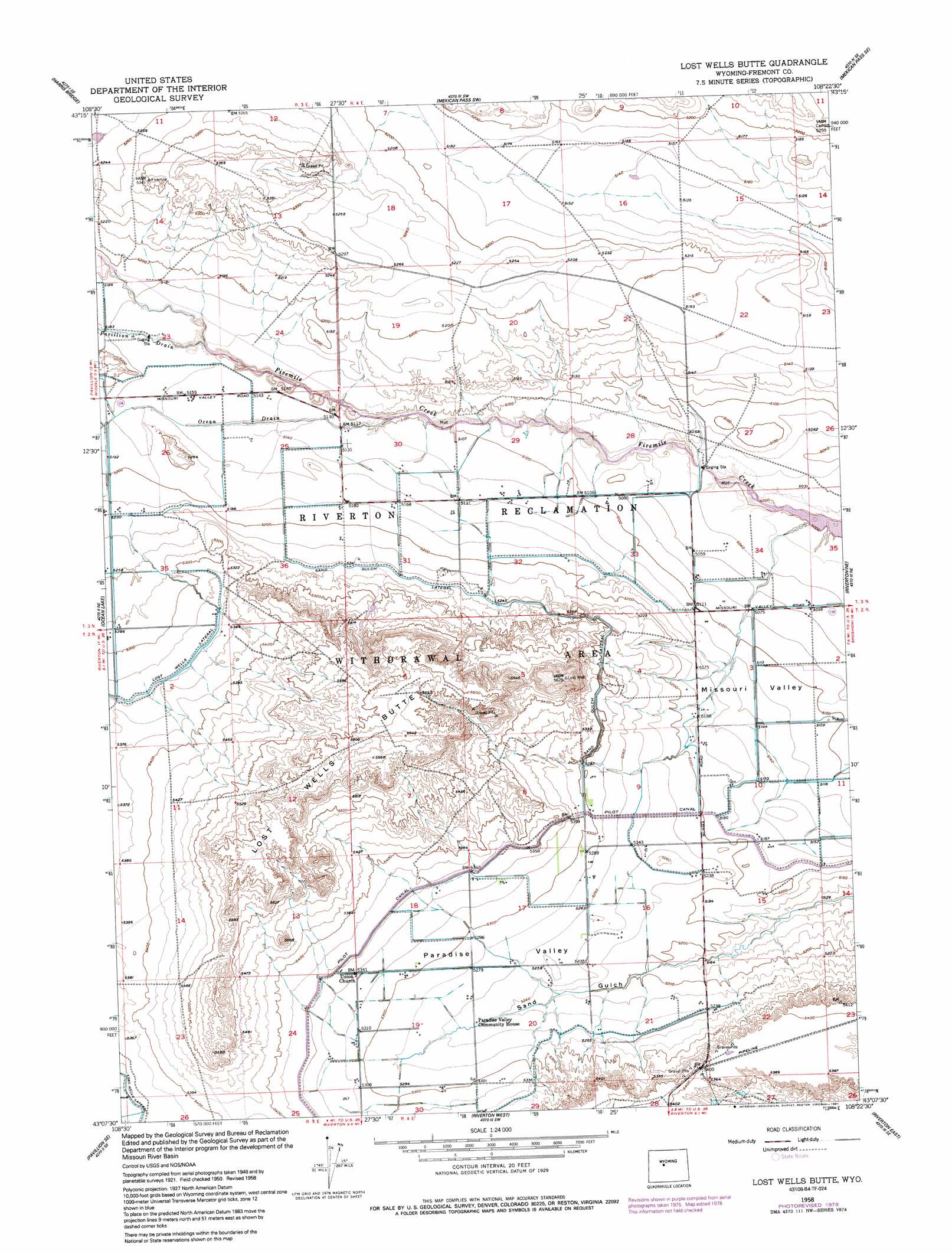
USGS Topo Quad 43108b4 - 1:24,000 scale
| Topo Map Name: | Lost Wells Butte |
| USGS Topo Quad ID: | 43108b4 |
| Print Size: | ca. 21 1/4" wide x 27" high |
| Southeast Coordinates: | 43.125° N latitude / 108.375° W longitude |
| Map Center Coordinates: | 43.1875° N latitude / 108.4375° W longitude |
| U.S. State: | WY |
| Filename: | o43108b4.jpg |
| Download Map JPG Image: | Lost Wells Butte topo map 1:24,000 scale |
| Map Type: | Topographic |
| Topo Series: | 7.5´ |
| Map Scale: | 1:24,000 |
| Source of Map Images: | United States Geological Survey (USGS) |
| Alternate Map Versions: |
Lost Wells Butte WY 1952, updated 1952 Download PDF Buy paper map Lost Wells Butte WY 1958, updated 1959 Download PDF Buy paper map Lost Wells Butte WY 1958, updated 1978 Download PDF Buy paper map Lost Wells Butte WY 1958, updated 1991 Download PDF Buy paper map Lost Wells Butte WY 2012 Download PDF Buy paper map Lost Wells Butte WY 2015 Download PDF Buy paper map |
1:24,000 Topo Quads surrounding Lost Wells Butte
Shotgun Butte |
Jenkins Mountain |
Mexican Pass |
Morrison Canyon |
Boysen |
Pavillion Butte |
Harris Bridge |
Mexican Pass Sw |
Mexican Pass Se |
Bonneville Sw |
Pavillion |
Ocean Lake |
Lost Wells Butte |
Riverton Ne |
Hidden Valley |
Mule Butte |
Pavillion Se |
Riverton West |
Riverton East |
Indian Butte |
Lander Nw |
Hudson |
Arapahoe |
Arapahoe Ne |
Alkali Butte |
> Back to 43108a1 at 1:100,000 scale
> Back to 43108a1 at 1:250,000 scale
> Back to U.S. Topo Maps home
Lost Wells Butte topo map: Gazetteer
Lost Wells Butte: Canals
Lost Wells Lateral elevation 1627m 5337′Ocean Drain elevation 1575m 5167′
Pavillion Drain elevation 1580m 5183′
S G Drain elevation 1611m 5285′
Sand Gulch Lateral elevation 1599m 5246′
Lost Wells Butte: Populated Places
Midvale elevation 1573m 5160′Lost Wells Butte: Streams
Ocean Drain elevation 1549m 5082′Pavillion Drain elevation 1572m 5157′
Lost Wells Butte: Summits
Lost Wells Butte elevation 1728m 5669′Lost Wells Butte: Valleys
Paradise Valley elevation 1577m 5173′Lost Wells Butte digital topo map on disk
Buy this Lost Wells Butte topo map showing relief, roads, GPS coordinates and other geographical features, as a high-resolution digital map file on DVD: