Wedding Of The Waters Topo Map Wyoming
To zoom in, hover over the map of Wedding Of The Waters
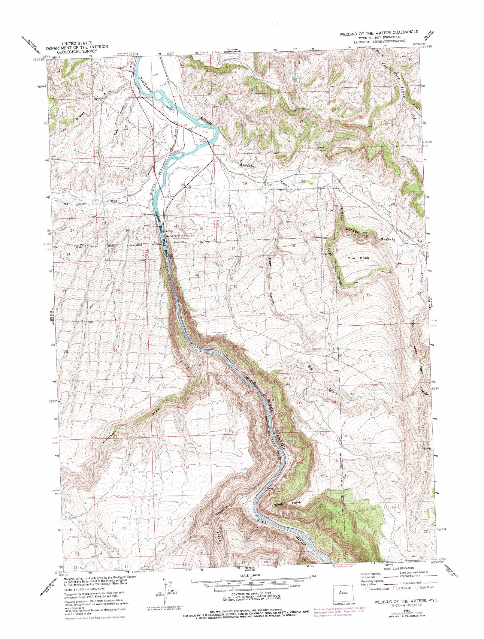
USGS Topo Quad 43108e2 - 1:24,000 scale
| Topo Map Name: | Wedding Of The Waters |
| USGS Topo Quad ID: | 43108e2 |
| Print Size: | ca. 21 1/4" wide x 27" high |
| Southeast Coordinates: | 43.5° N latitude / 108.125° W longitude |
| Map Center Coordinates: | 43.5625° N latitude / 108.1875° W longitude |
| U.S. State: | WY |
| Filename: | o43108e2.jpg |
| Download Map JPG Image: | Wedding Of The Waters topo map 1:24,000 scale |
| Map Type: | Topographic |
| Topo Series: | 7.5´ |
| Map Scale: | 1:24,000 |
| Source of Map Images: | United States Geological Survey (USGS) |
| Alternate Map Versions: |
Wedding Of The Waters WY 1960, updated 1962 Download PDF Buy paper map Wedding Of The Waters WY 1960, updated 1980 Download PDF Buy paper map Wedding of the Waters WY 2012 Download PDF Buy paper map Wedding of the Waters WY 2015 Download PDF Buy paper map |
1:24,000 Topo Quads surrounding Wedding Of The Waters
Gloin Reservoir |
Little Sand Draw |
Kirby |
Cedar Mountain |
Zimmerman Buttes |
Thompson Reservoirs |
Rattlesnake Gulch |
Thermoplis |
Red Hole |
Coyote Hill |
Potato Butte |
Nostrum Mountain |
Wedding Of The Waters |
Devil Slide |
Blue Hill |
Mexican Pass |
Morrison Canyon |
Boysen |
Birdseye Pass |
Guffy Peak |
Mexican Pass Sw |
Mexican Pass Se |
Bonneville Sw |
Bonneville |
Picard Ranch |
> Back to 43108e1 at 1:100,000 scale
> Back to 43108a1 at 1:250,000 scale
> Back to U.S. Topo Maps home
Wedding Of The Waters topo map: Gazetteer
Wedding Of The Waters: Bridges
Fourmile Bridge elevation 1325m 4347′Wedding Of The Waters: Cliffs
The Block elevation 1609m 5278′Windy Point elevation 1661m 5449′
Wedding Of The Waters: Dams
Jones Dam elevation 1372m 4501′Wedding Of The Waters: Mines
Talovich Mine elevation 1343m 4406′Wedding Of The Waters: Populated Places
Minnesela elevation 1337m 4386′Wedding Of The Waters: Reservoirs
Jones Reservoir elevation 1372m 4501′Wedding Of The Waters: Springs
Wind River Canyon Spring elevation 1330m 4363′Wedding Of The Waters: Streams
Buffalo Creek elevation 1326m 4350′Grass Creek elevation 1458m 4783′
Red Canyon Creek elevation 1330m 4363′
Wind River elevation 1363m 4471′
Wedding Of The Waters: Valleys
Big Draw elevation 1357m 4452′Black Canyon elevation 1383m 4537′
Bobcat Draw elevation 1324m 4343′
Buffalo Canyon elevation 1365m 4478′
Deer Canyon elevation 1342m 4402′
Deer Draw elevation 1326m 4350′
Grass Creek Canyon elevation 1484m 4868′
Johnson Draw elevation 1351m 4432′
Teeter Canyon elevation 1372m 4501′
Wind River Canyon elevation 1333m 4373′
Wedding Of The Waters digital topo map on disk
Buy this Wedding Of The Waters topo map showing relief, roads, GPS coordinates and other geographical features, as a high-resolution digital map file on DVD: