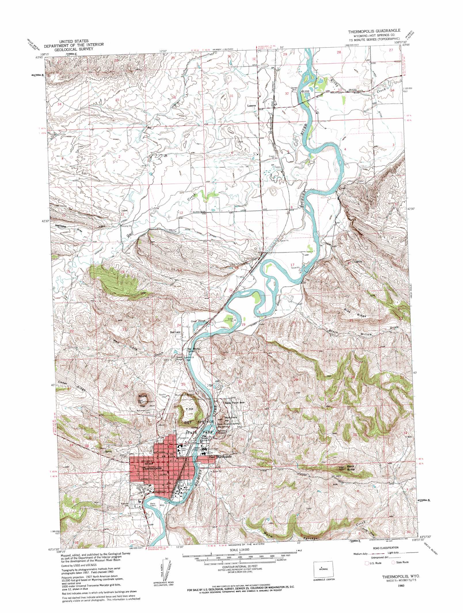
Thermoplis Topo Map Wyoming
To zoom in, hover over the map of Thermoplis
USGS Topo Quad 43108f2 - 1:24,000 scale
| Topo Map Name: | Thermoplis |
| USGS Topo Quad ID: | 43108f2 |
| Print Size: | ca. 21 1/4" wide x 27" high |
| Southeast Coordinates: | 43.625° N latitude / 108.125° W longitude |
| Map Center Coordinates: | 43.6875° N latitude / 108.1875° W longitude |
| U.S. State: | WY |
| Filename: | o43108f2.jpg |
| Download Map JPG Image: | Thermoplis topo map 1:24,000 scale |
| Map Type: | Topographic |
| Topo Series: | 7.5´ |
| Map Scale: | 1:24,000 |
| Source of Map Images: | United States Geological Survey (USGS) |
| Alternate Map Versions: |
Thermopolis WY 1960, updated 1962 Download PDF Buy paper map Thermopolis WY 1960, updated 1962 Download PDF Buy paper map Thermopolis WY 2012 Download PDF Buy paper map Thermopolis WY 2015 Download PDF Buy paper map |
1:24,000 Topo Quads surrounding Thermoplis
Blue Mesa West |
Blue Mesa East |
Chimney Gulch |
Neiber |
Banjo Flats West |
Gloin Reservoir |
Little Sand Draw |
Kirby |
Cedar Mountain |
Zimmerman Buttes |
Thompson Reservoirs |
Rattlesnake Gulch |
Thermoplis |
Red Hole |
Coyote Hill |
Potato Butte |
Nostrum Mountain |
Wedding Of The Waters |
Devil Slide |
Blue Hill |
Mexican Pass |
Morrison Canyon |
Boysen |
Birdseye Pass |
Guffy Peak |
> Back to 43108e1 at 1:100,000 scale
> Back to 43108a1 at 1:250,000 scale
> Back to U.S. Topo Maps home
Thermoplis topo map: Gazetteer
Thermoplis: Airports
Hot Springs County-Thermopolis Municipal Airport elevation 1401m 4596′Thermoplis: Basins
Devils Punch Bowl elevation 1343m 4406′Thermoplis: Canals
Dempsey Canal elevation 1343m 4406′Kirby Ditch elevation 1309m 4294′
Kirby Ditch elevation 1306m 4284′
South Side Ditch elevation 1336m 4383′
Thermoplis: Guts
Cover Slough elevation 1311m 4301′Thermoplis: Lakes
Rainbow Terraces elevation 1327m 4353′Scotch Plunge elevation 1317m 4320′
Thermoplis: Mines
Andreen Pit elevation 1318m 4324′Harvey Pit elevation 1314m 4311′
Lucerne Mine elevation 1321m 4333′
N-vam Mine elevation 1376m 4514′
Park Pit elevation 1324m 4343′
Shafer Pit elevation 1325m 4347′
Thermoplis: Parks
Hot Springs State Park elevation 1330m 4363′Thermoplis: Populated Places
East Thermopolis elevation 1323m 4340′Lucerne elevation 1315m 4314′
Red Lane elevation 1315m 4314′
Thermopolis elevation 1320m 4330′
Thermoplis: Ridges
Blue Ridge elevation 1450m 4757′Thermoplis: Springs
Big Spring elevation 1329m 4360′Black Sulphur Spring elevation 1332m 4370′
Teepee Fountain elevation 1318m 4324′
The Maytag Spring elevation 1315m 4314′
Thermopolis Hot Springs elevation 1328m 4356′
Thermoplis: Streams
Kirby Creek elevation 1299m 4261′Owl Creek elevation 1300m 4265′
South Fork Warm Springs Creek elevation 1414m 4639′
Warm Springs Creek elevation 1318m 4324′
Thermoplis: Summits
Black Butte elevation 1656m 5433′Monument Hill elevation 1428m 4685′
Round Top elevation 1524m 5000′
T Hill elevation 1459m 4786′
Thermoplis: Valleys
Black Willow Draw elevation 1310m 4297′Meeteetse Draw elevation 1354m 4442′
Red Lane Gulch elevation 1315m 4314′
Thermoplis digital topo map on disk
Buy this Thermoplis topo map showing relief, roads, GPS coordinates and other geographical features, as a high-resolution digital map file on DVD: