Downs Mountain Topo Map Wyoming
To zoom in, hover over the map of Downs Mountain
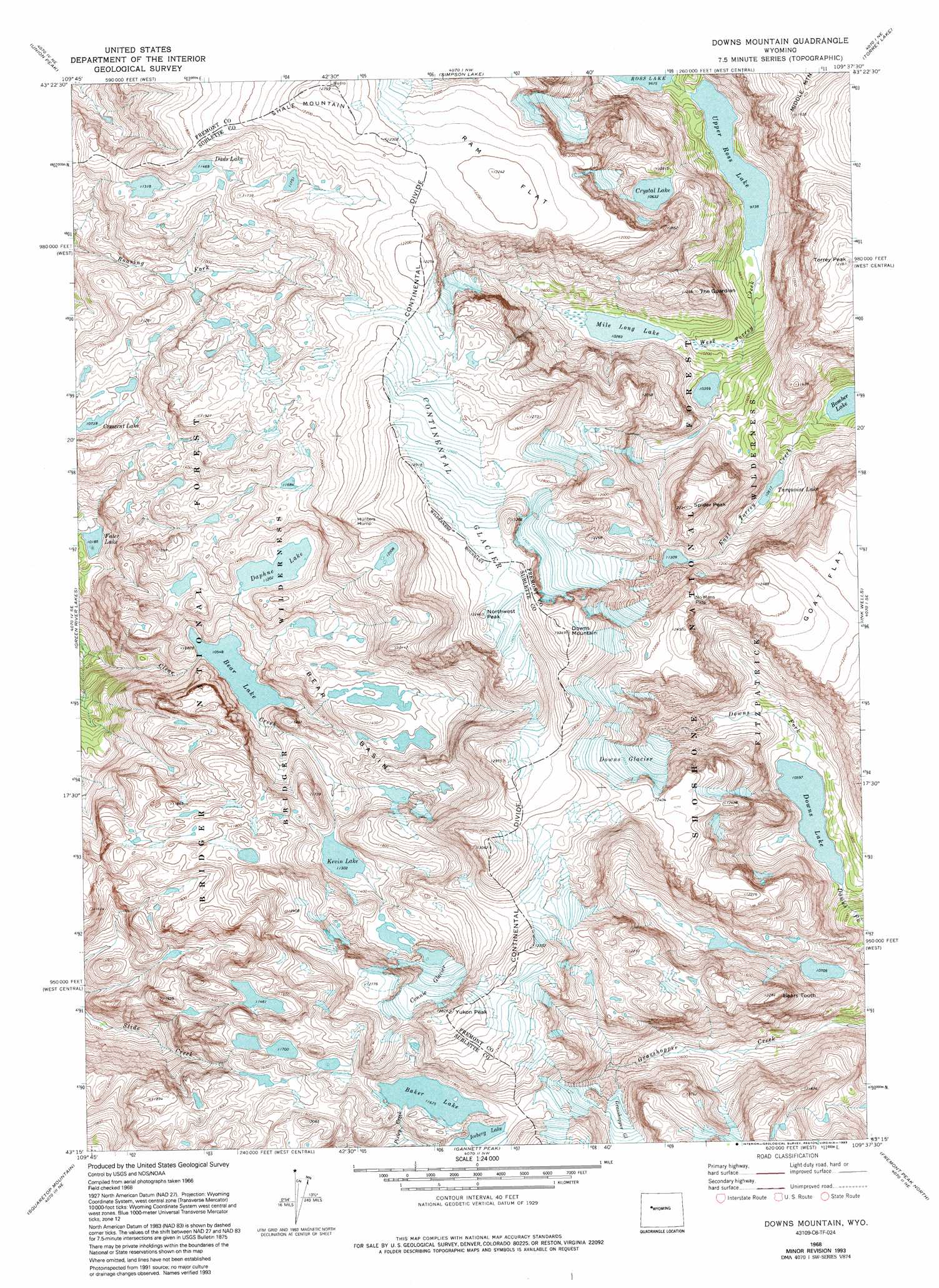
USGS Topo Quad 43109c6 - 1:24,000 scale
| Topo Map Name: | Downs Mountain |
| USGS Topo Quad ID: | 43109c6 |
| Print Size: | ca. 21 1/4" wide x 27" high |
| Southeast Coordinates: | 43.25° N latitude / 109.625° W longitude |
| Map Center Coordinates: | 43.3125° N latitude / 109.6875° W longitude |
| U.S. State: | WY |
| Filename: | o43109c6.jpg |
| Download Map JPG Image: | Downs Mountain topo map 1:24,000 scale |
| Map Type: | Topographic |
| Topo Series: | 7.5´ |
| Map Scale: | 1:24,000 |
| Source of Map Images: | United States Geological Survey (USGS) |
| Alternate Map Versions: |
Downs Mountain WY 1968, updated 1973 Download PDF Buy paper map Downs Mountain WY 1968, updated 1975 Download PDF Buy paper map Downs Mountain WY 1968, updated 1985 Download PDF Buy paper map Downs Mountain WY 1968, updated 1987 Download PDF Buy paper map Downs Mountain WY 1968, updated 1993 Download PDF Buy paper map Downs Mountain WY 1991, updated 1997 Download PDF Buy paper map Downs Mountain WY 2012 Download PDF Buy paper map Downs Mountain WY 2015 Download PDF Buy paper map |
| FStopo: | US Forest Service topo Downs Mountain is available: Download FStopo PDF Download FStopo TIF |
1:24,000 Topo Quads surrounding Downs Mountain
Fish Lake |
Warm Spring Mountain |
Dubois |
Mason Draw |
Bain Draw |
Fish Creek Park |
Union Peak |
Simpson Lake |
Torrey Lake |
Blue Holes |
Big Sheep Mountain |
Green River Lakes |
Downs Mountain |
Ink Wells |
Hays Park |
Kendall Mountain |
Squaretop Mountain |
Gannett Peak |
Fremont Peak North |
Bob Lakes |
New Fork Lakes |
Fremont Lake North |
Bridger Lakes |
Fremont Peak South |
Alpine Lake |
> Back to 43109a1 at 1:100,000 scale
> Back to 43108a1 at 1:250,000 scale
> Back to U.S. Topo Maps home
Downs Mountain topo map: Gazetteer
Downs Mountain: Basins
Bear Basin elevation 3440m 11286′Downs Mountain: Flats
Ram Flat elevation 3726m 12224′Downs Mountain: Gaps
No Mans Pass elevation 3707m 12162′Downs Mountain: Glaciers
Connie Glacier elevation 3664m 12020′Continental Glacier elevation 3909m 12824′
Downs Glacier elevation 3599m 11807′
Downs Mountain: Lakes
Baker Lake elevation 3560m 11679′Bear Lake elevation 3217m 10554′
Crescent Lake elevation 3275m 10744′
Crystal Lake elevation 3242m 10636′
Dads Lake elevation 3498m 11476′
Daphne Lake elevation 3416m 11207′
Downs Lake elevation 3246m 10649′
Faler Lake elevation 3106m 10190′
Iceberg Lake elevation 3583m 11755′
Kevin Lake elevation 3447m 11309′
Mile Long Lake elevation 3136m 10288′
Turquoise Lake elevation 3213m 10541′
Upper Ross Lake elevation 2970m 9744′
Downs Mountain: Mines
Clear Creek Mine elevation 3412m 11194′Downs Mountain: Summits
Bears Tooth elevation 3503m 11492′Downs Mountain elevation 4063m 13330′
Hunters Hump elevation 3821m 12536′
Northwest Peak elevation 3984m 13070′
Shale Mountain elevation 3770m 12368′
Spider Peak elevation 3711m 12175′
The Guardian elevation 3406m 11174′
Torrey Peak elevation 3680m 12073′
Yukon Peak elevation 3884m 12742′
Downs Mountain digital topo map on disk
Buy this Downs Mountain topo map showing relief, roads, GPS coordinates and other geographical features, as a high-resolution digital map file on DVD: