Blue Holes Topo Map Wyoming
To zoom in, hover over the map of Blue Holes
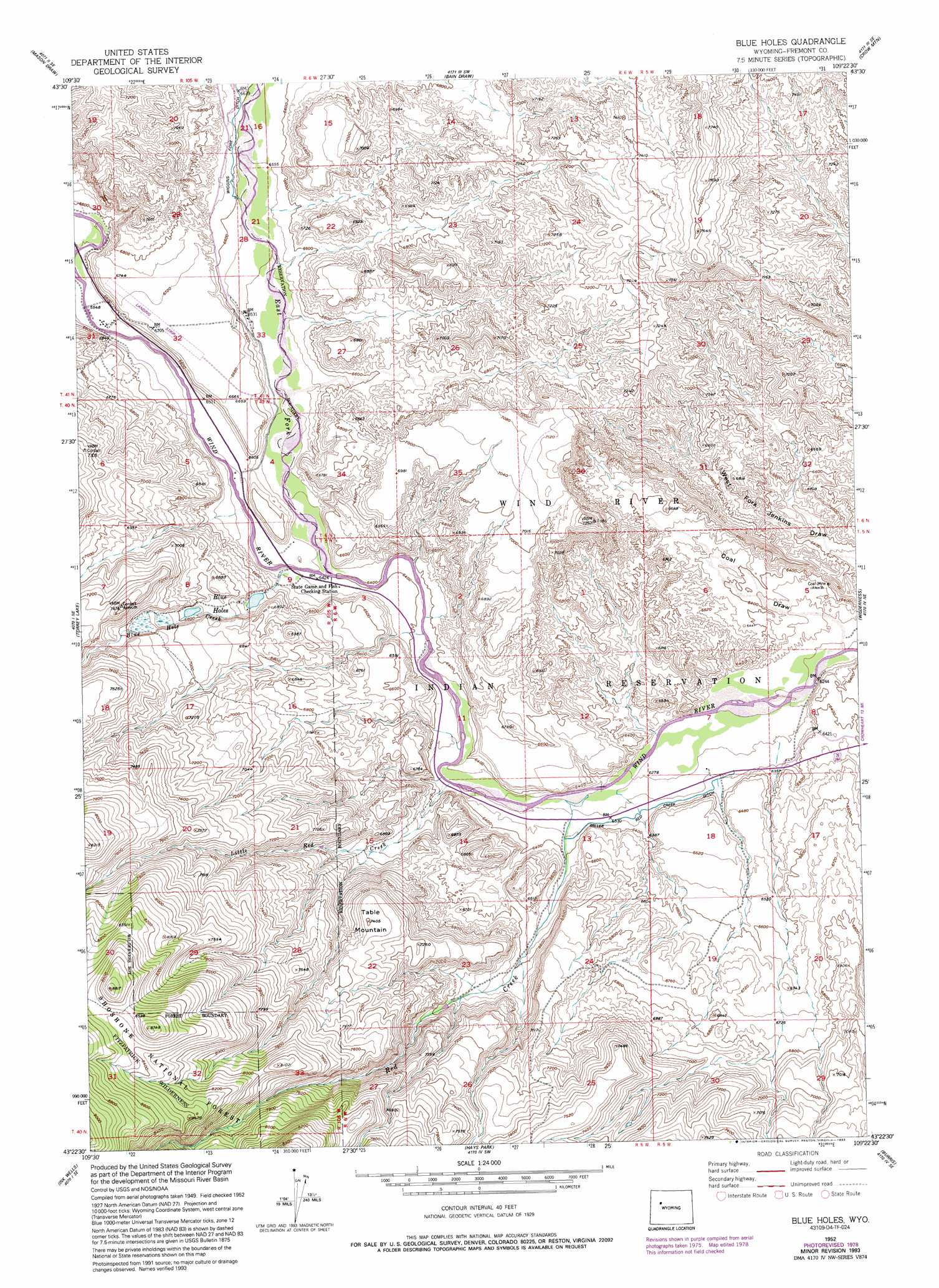
USGS Topo Quad 43109d4 - 1:24,000 scale
| Topo Map Name: | Blue Holes |
| USGS Topo Quad ID: | 43109d4 |
| Print Size: | ca. 21 1/4" wide x 27" high |
| Southeast Coordinates: | 43.375° N latitude / 109.375° W longitude |
| Map Center Coordinates: | 43.4375° N latitude / 109.4375° W longitude |
| U.S. State: | WY |
| Filename: | o43109d4.jpg |
| Download Map JPG Image: | Blue Holes topo map 1:24,000 scale |
| Map Type: | Topographic |
| Topo Series: | 7.5´ |
| Map Scale: | 1:24,000 |
| Source of Map Images: | United States Geological Survey (USGS) |
| Alternate Map Versions: |
Blue Holes WY 1952, updated 1954 Download PDF Buy paper map Blue Holes WY 1952, updated 1963 Download PDF Buy paper map Blue Holes WY 1952, updated 1985 Download PDF Buy paper map Blue Holes WY 1952, updated 1993 Download PDF Buy paper map Blue Holes WY 1991, updated 1997 Download PDF Buy paper map Blue Holes WY 2012 Download PDF Buy paper map Blue Holes WY 2015 Download PDF Buy paper map |
| FStopo: | US Forest Service topo Blue Holes is available: Download FStopo PDF Download FStopo TIF |
1:24,000 Topo Quads surrounding Blue Holes
Ramshorn Peak |
Indian Point |
Castle Rock |
East Fork Basin |
Monument Peak |
Dubois |
Mason Draw |
Bain Draw |
Crow Mountain |
Johnson Draw |
Simpson Lake |
Torrey Lake |
Blue Holes |
Wilderness |
Crowheart Nw |
Downs Mountain |
Ink Wells |
Hays Park |
Burris |
Crowheart |
Gannett Peak |
Fremont Peak North |
Bob Lakes |
Kirkland Park |
Bull Lake West |
> Back to 43109a1 at 1:100,000 scale
> Back to 43108a1 at 1:250,000 scale
> Back to U.S. Topo Maps home
Blue Holes topo map: Gazetteer
Blue Holes: Canals
Miller Red Creek Canal elevation 1964m 6443′Blue Holes: Mines
Red Creek Mine elevation 2382m 7814′Blue Holes: Streams
Blue Hole Creek elevation 1962m 6437′East Fork Wind River elevation 1952m 6404′
Little Red Creek elevation 1928m 6325′
Red Creek elevation 1920m 6299′
Blue Holes: Summits
Table Mountain elevation 2250m 7381′Blue Holes digital topo map on disk
Buy this Blue Holes topo map showing relief, roads, GPS coordinates and other geographical features, as a high-resolution digital map file on DVD: