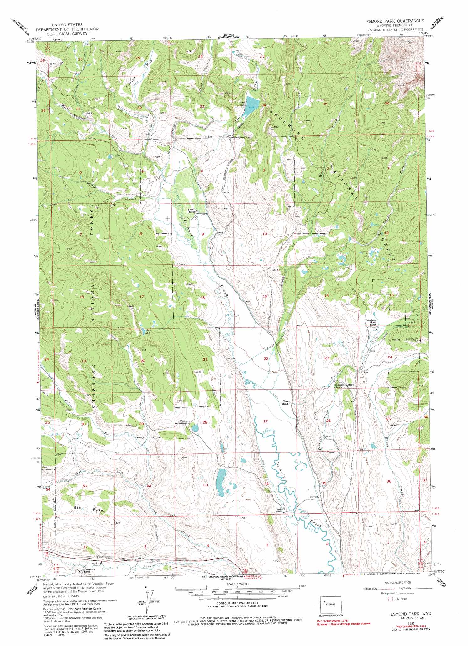
Esmond Park Topo Map Wyoming
To zoom in, hover over the map of Esmond Park
USGS Topo Quad 43109f7 - 1:24,000 scale
| Topo Map Name: | Esmond Park |
| USGS Topo Quad ID: | 43109f7 |
| Print Size: | ca. 21 1/4" wide x 27" high |
| Southeast Coordinates: | 43.625° N latitude / 109.75° W longitude |
| Map Center Coordinates: | 43.6875° N latitude / 109.8125° W longitude |
| U.S. State: | WY |
| Filename: | o43109f7.jpg |
| Download Map JPG Image: | Esmond Park topo map 1:24,000 scale |
| Map Type: | Topographic |
| Topo Series: | 7.5´ |
| Map Scale: | 1:24,000 |
| Source of Map Images: | United States Geological Survey (USGS) |
| Alternate Map Versions: |
Esmond Park WY 1956, updated 1958 Download PDF Buy paper map Esmond Park WY 1956, updated 1963 Download PDF Buy paper map Esmond Park WY 1956, updated 1985 Download PDF Buy paper map Esmond Park WY 1991, updated 1997 Download PDF Buy paper map Esmond Park WY 2012 Download PDF Buy paper map Esmond Park WY 2015 Download PDF Buy paper map |
| FStopo: | US Forest Service topo Esmond Park is available: Download FStopo PDF Download FStopo TIF |
1:24,000 Topo Quads surrounding Esmond Park
Crater Lake |
Ferry Lake |
Younts Peak |
Hardluck Mountain |
Emerald Lake |
Togwotee Pass |
Dundee Meadows |
Shoshone Pass |
Five Pockets |
Snow Lake |
Lava Mountain |
Kisinger Lakes |
Esmond Park |
Ramshorn Peak |
Indian Point |
Sheridan Pass |
Fish Lake |
Warm Spring Mountain |
Dubois |
Mason Draw |
Mosquito Lake |
Fish Creek Park |
Union Peak |
Simpson Lake |
Torrey Lake |
> Back to 43109e1 at 1:100,000 scale
> Back to 43108a1 at 1:250,000 scale
> Back to U.S. Topo Maps home
Esmond Park topo map: Gazetteer
Esmond Park: Dams
Trail Lake Control Dam elevation 2648m 8687′Trail Lake Dam elevation 2452m 8044′
Esmond Park: Flats
Esmond Park elevation 2431m 7975′Esmond Park: Lakes
Gap Lake elevation 2462m 8077′Trail Lake elevation 2450m 8038′
Esmond Park: Reservoirs
Trail Lake elevation 2452m 8044′Trail Lake elevation 2648m 8687′
Esmond Park: Streams
East Du Noir Creek elevation 2280m 7480′East Fork Long Creek elevation 2380m 7808′
East Fork Sixmile Creek elevation 2376m 7795′
Esmond Creek elevation 2297m 7536′
Falls Creek elevation 2401m 7877′
Fivemile Creek elevation 2270m 7447′
Fourmile Creek elevation 2244m 7362′
Long Creek elevation 2278m 7473′
Middle Fork Long Creek elevation 2345m 7693′
Sixmile Creek elevation 2253m 7391′
Trail Creek elevation 2380m 7808′
West Du Noir Creek elevation 2280m 7480′
West Fork Long Creek elevation 2345m 7693′
West Fork Sixmile Creek elevation 2376m 7795′
Willow Branch elevation 2280m 7480′
Wolf Creek elevation 2484m 8149′
Esmond Park: Trails
Du Noir Trail elevation 2488m 8162′Esmond Park digital topo map on disk
Buy this Esmond Park topo map showing relief, roads, GPS coordinates and other geographical features, as a high-resolution digital map file on DVD: