Wiggins Peak Topo Map Wyoming
To zoom in, hover over the map of Wiggins Peak
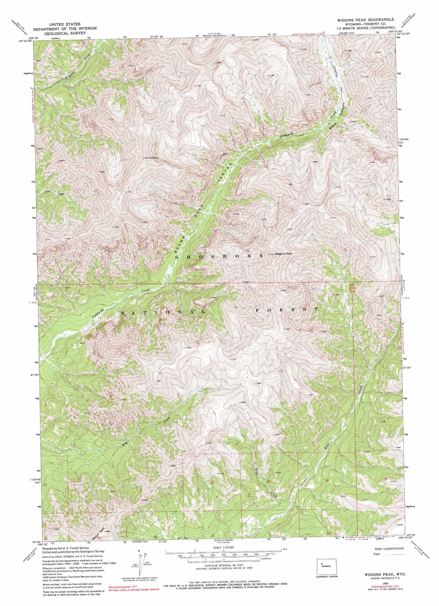
USGS Topo Quad 43109g4 - 1:24,000 scale
| Topo Map Name: | Wiggins Peak |
| USGS Topo Quad ID: | 43109g4 |
| Print Size: | ca. 21 1/4" wide x 27" high |
| Southeast Coordinates: | 43.75° N latitude / 109.375° W longitude |
| Map Center Coordinates: | 43.8125° N latitude / 109.4375° W longitude |
| U.S. State: | WY |
| Filename: | o43109g4.jpg |
| Download Map JPG Image: | Wiggins Peak topo map 1:24,000 scale |
| Map Type: | Topographic |
| Topo Series: | 7.5´ |
| Map Scale: | 1:24,000 |
| Source of Map Images: | United States Geological Survey (USGS) |
| Alternate Map Versions: |
Wiggins Peak WY 1969, updated 1971 Download PDF Buy paper map Wiggins Peak WY 1969, updated 1979 Download PDF Buy paper map Wiggins Peak WY 1991, updated 1997 Download PDF Buy paper map Wiggins Peak WY 1991, updated 1997 Download PDF Buy paper map Wiggins Peak WY 2012 Download PDF Buy paper map Wiggins Peak WY 2015 Download PDF Buy paper map |
| FStopo: | US Forest Service topo Wiggins Peak is available: Download FStopo PDF Download FStopo TIF |
1:24,000 Topo Quads surrounding Wiggins Peak
Fall Creek |
Needle Mountain |
Irish Rock |
Phelps Mountain |
Pitchfork |
Hardluck Mountain |
Emerald Lake |
Mount Burwell |
Francs Peak |
Dick Creek Lakes |
Five Pockets |
Snow Lake |
Wiggins Peak |
Dunrud Peak |
Twin Peaks |
Ramshorn Peak |
Indian Point |
Castle Rock |
East Fork Basin |
Monument Peak |
Dubois |
Mason Draw |
Bain Draw |
Crow Mountain |
Johnson Draw |
> Back to 43109e1 at 1:100,000 scale
> Back to 43108a1 at 1:250,000 scale
> Back to U.S. Topo Maps home
Wiggins Peak topo map: Gazetteer
Wiggins Peak: Streams
Blue Creek elevation 2635m 8645′Wiggins Peak: Summits
Wiggins Peak elevation 3713m 12181′Wiggins Peak: Trails
Bear Creek Trail elevation 2850m 9350′Wiggins Peak: Valleys
Black Canyon elevation 2955m 9694′Brown Rock Canyon elevation 2687m 8815′
Wiggins Peak digital topo map on disk
Buy this Wiggins Peak topo map showing relief, roads, GPS coordinates and other geographical features, as a high-resolution digital map file on DVD: