Shoshone Pass Topo Map Wyoming
To zoom in, hover over the map of Shoshone Pass
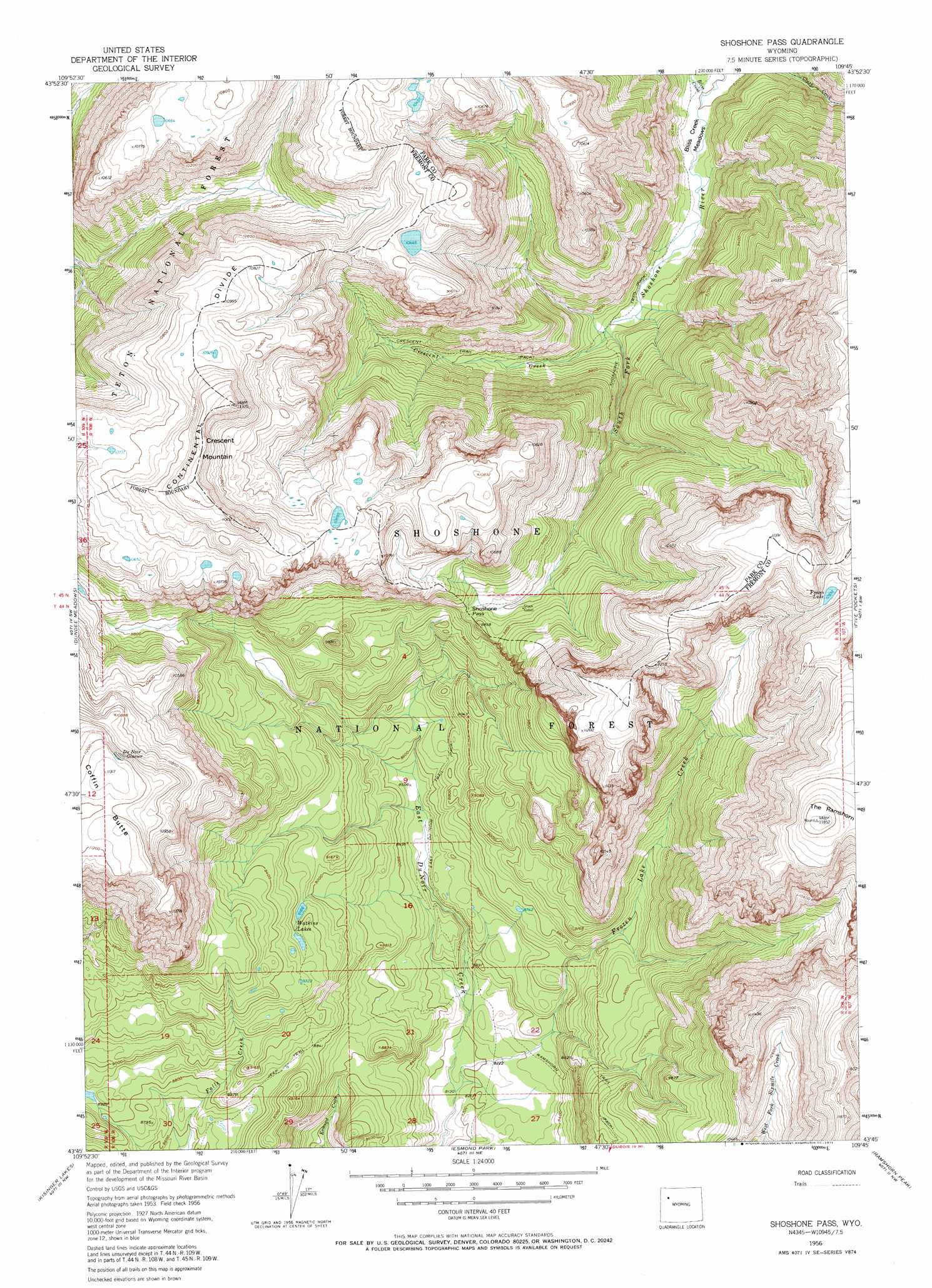
USGS Topo Quad 43109g7 - 1:24,000 scale
| Topo Map Name: | Shoshone Pass |
| USGS Topo Quad ID: | 43109g7 |
| Print Size: | ca. 21 1/4" wide x 27" high |
| Southeast Coordinates: | 43.75° N latitude / 109.75° W longitude |
| Map Center Coordinates: | 43.8125° N latitude / 109.8125° W longitude |
| U.S. State: | WY |
| Filename: | o43109g7.jpg |
| Download Map JPG Image: | Shoshone Pass topo map 1:24,000 scale |
| Map Type: | Topographic |
| Topo Series: | 7.5´ |
| Map Scale: | 1:24,000 |
| Source of Map Images: | United States Geological Survey (USGS) |
| Alternate Map Versions: |
Shoshone Pass WY 1956, updated 1958 Download PDF Buy paper map Shoshone Pass WY 1956, updated 1971 Download PDF Buy paper map Shoshone Pass WY 1991, updated 1997 Download PDF Buy paper map Shoshone Pass WY 2012 Download PDF Buy paper map Shoshone Pass WY 2015 Download PDF Buy paper map |
| FStopo: | US Forest Service topo Shoshone Pass is available: Download FStopo PDF Download FStopo TIF |
1:24,000 Topo Quads surrounding Shoshone Pass
Yellowstone Point |
Thorofare Plateau |
Yellow Mountain |
Fall Creek |
Needle Mountain |
Crater Lake |
Ferry Lake |
Younts Peak |
Hardluck Mountain |
Emerald Lake |
Togwotee Pass |
Dundee Meadows |
Shoshone Pass |
Five Pockets |
Snow Lake |
Lava Mountain |
Kisinger Lakes |
Esmond Park |
Ramshorn Peak |
Indian Point |
Sheridan Pass |
Fish Lake |
Warm Spring Mountain |
Dubois |
Mason Draw |
> Back to 43109e1 at 1:100,000 scale
> Back to 43108a1 at 1:250,000 scale
> Back to U.S. Topo Maps home
Shoshone Pass topo map: Gazetteer
Shoshone Pass: Gaps
Shoshone Pass elevation 2947m 9668′Shoshone Pass: Glaciers
DuNoir Glacier elevation 3401m 11158′Shoshone Pass: Lakes
Frozen Lake elevation 3337m 10948′Perry N Boday Lake elevation 3120m 10236′
Watkins Lakes elevation 2793m 9163′
Shoshone Pass: Streams
Bliss Creek elevation 2499m 8198′Boday Creek elevation 2638m 8654′
Crescent Creek elevation 2567m 8421′
Frozen Lake Creek elevation 2478m 8129′
Perry N Boday Creek elevation 2595m 8513′
Shoshone Pass: Summits
Coffin Butte elevation 3445m 11302′Crescent Mountain elevation 3430m 11253′
Shoshone Pass: Trails
Crescent Trail elevation 2736m 8976′East Du Noir Trail elevation 2596m 8517′
Ramshorn Trail elevation 2651m 8697′
Shoshone Trail elevation 2559m 8395′
Shoshone Pass: Valleys
Waterfalls Canyon elevation 2792m 9160′Shoshone Pass digital topo map on disk
Buy this Shoshone Pass topo map showing relief, roads, GPS coordinates and other geographical features, as a high-resolution digital map file on DVD: