Kismet Peak Topo Map Wyoming
To zoom in, hover over the map of Kismet Peak
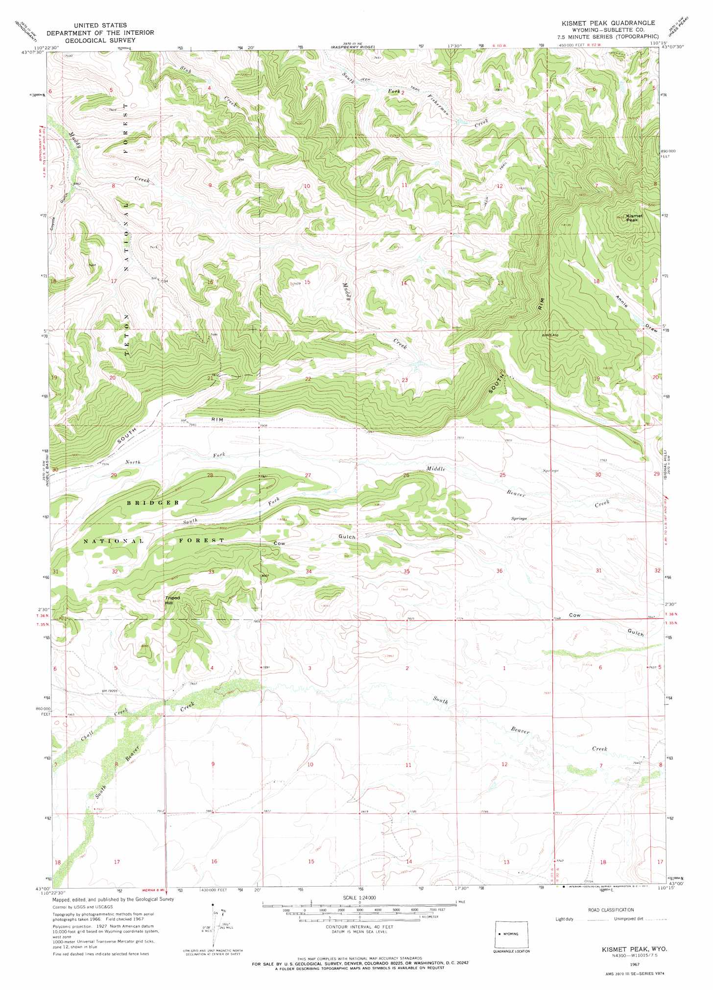
USGS Topo Quad 43110a3 - 1:24,000 scale
| Topo Map Name: | Kismet Peak |
| USGS Topo Quad ID: | 43110a3 |
| Print Size: | ca. 21 1/4" wide x 27" high |
| Southeast Coordinates: | 43° N latitude / 110.25° W longitude |
| Map Center Coordinates: | 43.0625° N latitude / 110.3125° W longitude |
| U.S. State: | WY |
| Filename: | o43110a3.jpg |
| Download Map JPG Image: | Kismet Peak topo map 1:24,000 scale |
| Map Type: | Topographic |
| Topo Series: | 7.5´ |
| Map Scale: | 1:24,000 |
| Source of Map Images: | United States Geological Survey (USGS) |
| Alternate Map Versions: |
Kismet Peak WY 1967, updated 1971 Download PDF Buy paper map Kismet Peak WY 2012 Download PDF Buy paper map Kismet Peak WY 2015 Download PDF Buy paper map |
| FStopo: | US Forest Service topo Kismet Peak is available: Download FStopo PDF Download FStopo TIF |
1:24,000 Topo Quads surrounding Kismet Peak
Bull Creek |
Granite Falls |
Doubletop Peak |
Tosi Peak |
Klondike Hill |
Clause Peak |
Bondurant |
Raspberry Ridge |
Pass Peak |
Dodge Butte |
Hoback Peak |
Noble Basin |
Kismet Peak |
Signal Hill |
Warren Bridge |
Lookout Mountain |
Prospect Peak |
Merna Butte |
Webb Draw |
Daniel Junction |
Triple Peak |
Maki Creek |
Halfway |
Onion Springs |
Daniel |
> Back to 43110a1 at 1:100,000 scale
> Back to 43110a1 at 1:250,000 scale
> Back to U.S. Topo Maps home
Kismet Peak topo map: Gazetteer
Kismet Peak: Cliffs
South Rim elevation 2406m 7893′Kismet Peak: Streams
Chall Creek elevation 2388m 7834′North Fork Middle Beaver Creek elevation 2378m 7801′
South Fork Middle Beaver Creek elevation 2378m 7801′
Kismet Peak: Summits
Kismet Peak elevation 2565m 8415′Tripod Hill elevation 2526m 8287′
Kismet Peak: Valleys
Coyote Gulch elevation 2117m 6945′Meridional Valley elevation 2393m 7851′
Kismet Peak digital topo map on disk
Buy this Kismet Peak topo map showing relief, roads, GPS coordinates and other geographical features, as a high-resolution digital map file on DVD: