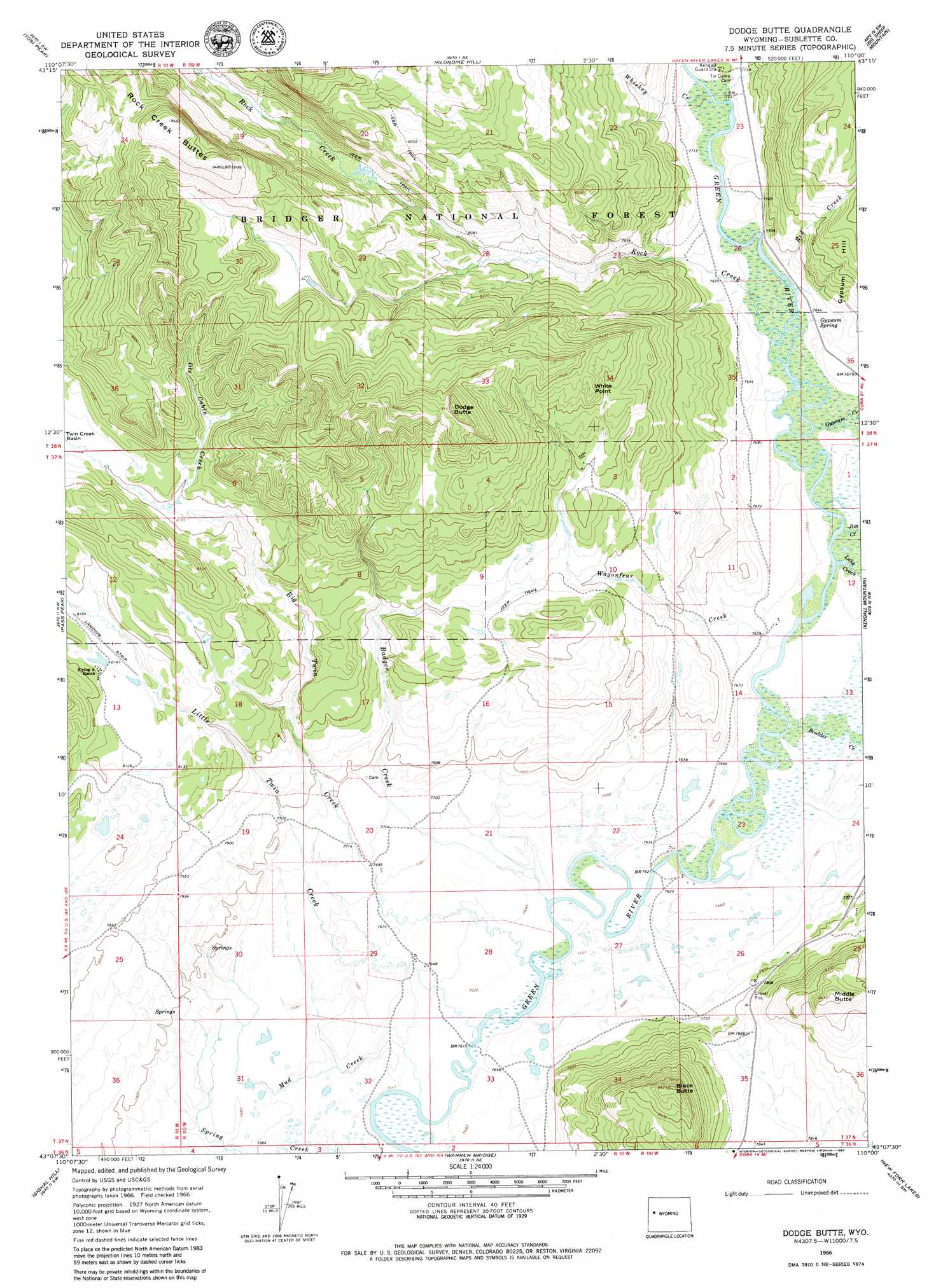
Dodge Butte Topo Map Wyoming
To zoom in, hover over the map of Dodge Butte
USGS Topo Quad 43110b1 - 1:24,000 scale
| Topo Map Name: | Dodge Butte |
| USGS Topo Quad ID: | 43110b1 |
| Print Size: | ca. 21 1/4" wide x 27" high |
| Southeast Coordinates: | 43.125° N latitude / 110° W longitude |
| Map Center Coordinates: | 43.1875° N latitude / 110.0625° W longitude |
| U.S. State: | WY |
| Filename: | o43110b1.jpg |
| Download Map JPG Image: | Dodge Butte topo map 1:24,000 scale |
| Map Type: | Topographic |
| Topo Series: | 7.5´ |
| Map Scale: | 1:24,000 |
| Source of Map Images: | United States Geological Survey (USGS) |
| Alternate Map Versions: |
Dodge Butte WY 1966, updated 1971 Download PDF Buy paper map Dodge Butte WY 1966, updated 1980 Download PDF Buy paper map Dodge Butte WY 1966, updated 1980 Download PDF Buy paper map Dodge Butte WY 2012 Download PDF Buy paper map Dodge Butte WY 2015 Download PDF Buy paper map |
| FStopo: | US Forest Service topo Dodge Butte is available: Download FStopo PDF Download FStopo TIF |
1:24,000 Topo Quads surrounding Dodge Butte
Darwin Peak |
Ouzel Falls |
Mosquito Lake |
Fish Creek Park |
Union Peak |
Doubletop Peak |
Tosi Peak |
Klondike Hill |
Big Sheep Mountain |
Green River Lakes |
Raspberry Ridge |
Pass Peak |
Dodge Butte |
Kendall Mountain |
Squaretop Mountain |
Kismet Peak |
Signal Hill |
Warren Bridge |
New Fork Lakes |
Fremont Lake North |
Merna Butte |
Webb Draw |
Daniel Junction |
Cora |
Fremont Lake South |
> Back to 43110a1 at 1:100,000 scale
> Back to 43110a1 at 1:250,000 scale
> Back to U.S. Topo Maps home
Dodge Butte topo map: Gazetteer
Dodge Butte: Cliffs
White Point elevation 2614m 8576′Dodge Butte: Mines
Johnson Pit Mine elevation 2381m 7811′Dodge Butte: Springs
Gypsum Spring elevation 2340m 7677′Dodge Butte: Streams
Badger Creek elevation 2322m 7618′Big Twin Creek elevation 2321m 7614′
Boulder Creek elevation 2324m 7624′
Gypsum Creek elevation 2327m 7634′
Jim Creek elevation 2324m 7624′
Lake Creek elevation 2324m 7624′
Little Twin Creek elevation 2321m 7614′
Mud Creek elevation 2321m 7614′
Ole Cabin Creek elevation 2497m 8192′
Pot Creek elevation 2328m 7637′
Red Creek elevation 2331m 7647′
Rock Creek elevation 2329m 7641′
Wagonfeur Creek elevation 2324m 7624′
Whiskey Creek elevation 2335m 7660′
Dodge Butte: Summits
Black Butte elevation 2621m 8599′Dodge Butte elevation 2781m 9124′
Middle Butte elevation 2564m 8412′
Rock Creek Buttes elevation 2910m 9547′
Dodge Butte: Trails
Sawmill Park Trail elevation 2796m 9173′Dodge Butte digital topo map on disk
Buy this Dodge Butte topo map showing relief, roads, GPS coordinates and other geographical features, as a high-resolution digital map file on DVD: