Raspberry Ridge Topo Map Wyoming
To zoom in, hover over the map of Raspberry Ridge
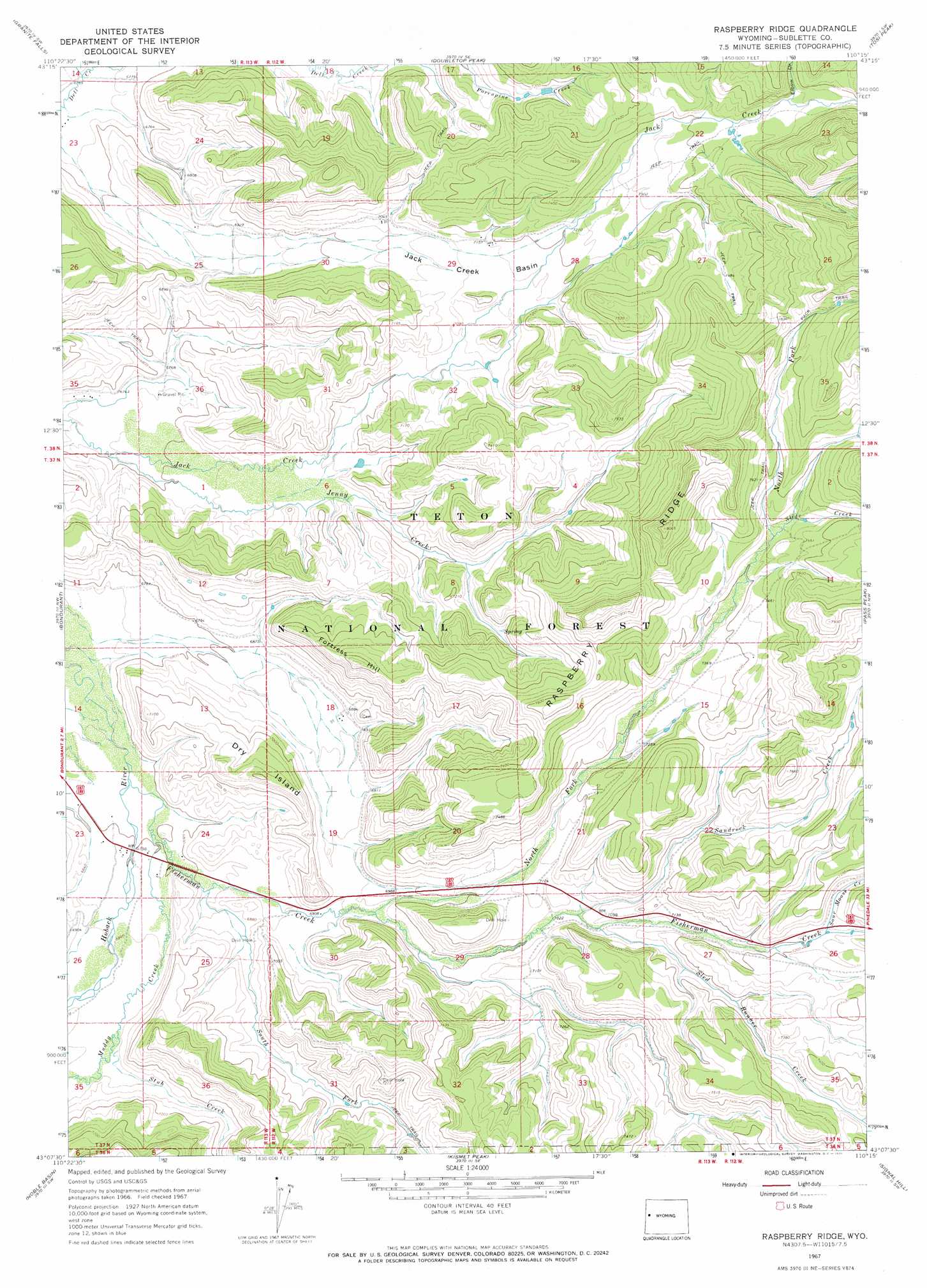
USGS Topo Quad 43110b3 - 1:24,000 scale
| Topo Map Name: | Raspberry Ridge |
| USGS Topo Quad ID: | 43110b3 |
| Print Size: | ca. 21 1/4" wide x 27" high |
| Southeast Coordinates: | 43.125° N latitude / 110.25° W longitude |
| Map Center Coordinates: | 43.1875° N latitude / 110.3125° W longitude |
| U.S. State: | WY |
| Filename: | o43110b3.jpg |
| Download Map JPG Image: | Raspberry Ridge topo map 1:24,000 scale |
| Map Type: | Topographic |
| Topo Series: | 7.5´ |
| Map Scale: | 1:24,000 |
| Source of Map Images: | United States Geological Survey (USGS) |
| Alternate Map Versions: |
Raspberry Ridge WY 1967, updated 1971 Download PDF Buy paper map Raspberry Ridge WY 1967, updated 1971 Download PDF Buy paper map Raspberry Ridge WY 2012 Download PDF Buy paper map Raspberry Ridge WY 2015 Download PDF Buy paper map |
| FStopo: | US Forest Service topo Raspberry Ridge is available: Download FStopo PDF Download FStopo TIF |
1:24,000 Topo Quads surrounding Raspberry Ridge
Turquoise Lake |
Crystal Peak |
Darwin Peak |
Ouzel Falls |
Mosquito Lake |
Bull Creek |
Granite Falls |
Doubletop Peak |
Tosi Peak |
Klondike Hill |
Clause Peak |
Bondurant |
Raspberry Ridge |
Pass Peak |
Dodge Butte |
Hoback Peak |
Noble Basin |
Kismet Peak |
Signal Hill |
Warren Bridge |
Lookout Mountain |
Prospect Peak |
Merna Butte |
Webb Draw |
Daniel Junction |
> Back to 43110a1 at 1:100,000 scale
> Back to 43110a1 at 1:250,000 scale
> Back to U.S. Topo Maps home
Raspberry Ridge topo map: Gazetteer
Raspberry Ridge: Basins
Jack Creek Basin elevation 2178m 7145′Raspberry Ridge: Mines
Fisherman Pit Mine elevation 2179m 7148′Raspberry Ridge: Ridges
Raspberry Ridge elevation 2403m 7883′Raspberry Ridge: Streams
Fisherman Creek elevation 2198m 7211′Fisherman Creek elevation 2065m 6774′
Jenny Creek elevation 2058m 6751′
Mill Creek elevation 2111m 6925′
Muddy Creek elevation 2072m 6797′
North Fork Fisherman Creek elevation 2114m 6935′
Sandrock Creek elevation 2146m 7040′
Sled Runner Creek elevation 2148m 7047′
Slide Creek elevation 2272m 7454′
Sour Moose Creek elevation 2200m 7217′
South Fork Fisherman Creek elevation 2077m 6814′
Stub Creek elevation 2095m 6873′
Raspberry Ridge: Summits
Dry Island elevation 2198m 7211′Fortress Hill elevation 2271m 7450′
Robinson Butte elevation 2187m 7175′
Raspberry Ridge: Valleys
Elbow Draw elevation 2285m 7496′Riling Draw elevation 2055m 6742′
Raspberry Ridge digital topo map on disk
Buy this Raspberry Ridge topo map showing relief, roads, GPS coordinates and other geographical features, as a high-resolution digital map file on DVD: