Pine Creek Topo Map Wyoming
To zoom in, hover over the map of Pine Creek
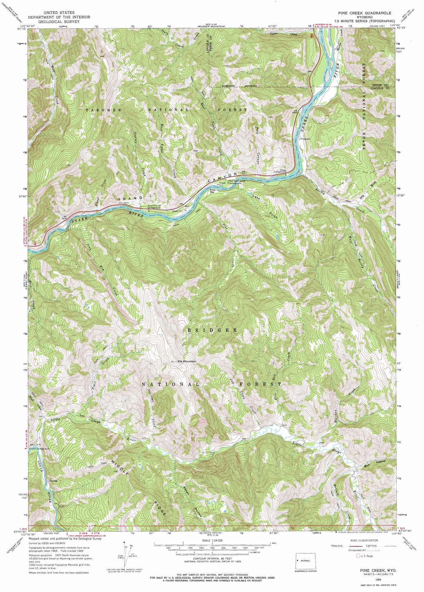
USGS Topo Quad 43110b7 - 1:24,000 scale
| Topo Map Name: | Pine Creek |
| USGS Topo Quad ID: | 43110b7 |
| Print Size: | ca. 21 1/4" wide x 27" high |
| Southeast Coordinates: | 43.125° N latitude / 110.75° W longitude |
| Map Center Coordinates: | 43.1875° N latitude / 110.8125° W longitude |
| U.S. State: | WY |
| Filename: | o43110b7.jpg |
| Download Map JPG Image: | Pine Creek topo map 1:24,000 scale |
| Map Type: | Topographic |
| Topo Series: | 7.5´ |
| Map Scale: | 1:24,000 |
| Source of Map Images: | United States Geological Survey (USGS) |
| Alternate Map Versions: |
Pine Creek WY 1965, updated 1968 Download PDF Buy paper map Pine Creek WY 1996, updated 1998 Download PDF Buy paper map Pine Creek WY 2012 Download PDF Buy paper map Pine Creek WY 2015 Download PDF Buy paper map |
| FStopo: | US Forest Service topo Pine Creek is available: Download FStopo PDF Download FStopo TIF |
1:24,000 Topo Quads surrounding Pine Creek
Palisades Peak |
Teton Pass |
Jackson |
Cache Creek |
Turquoise Lake |
Mount Baird |
Observation Peak |
Munger Mountain |
Camp Davis |
Bull Creek |
Alpine |
Ferry Peak |
Pine Creek |
Bailey Lake |
Clause Peak |
Etna |
Stewart Peak |
Deer Creek |
Pickle Pass |
Hoback Peak |
Thayne West |
Thayne East |
Man Peak |
Blind Bull Creek |
Lookout Mountain |
> Back to 43110a1 at 1:100,000 scale
> Back to 43110a1 at 1:250,000 scale
> Back to U.S. Topo Maps home
Pine Creek topo map: Gazetteer
Pine Creek: Bars
Pine Bar elevation 1770m 5807′Pine Creek: Mines
Davis Claim elevation 1872m 6141′Pine Bar Diggings elevation 1986m 6515′
Pine Creek: Streams
Bailey Creek elevation 1759m 5770′Cabin Creek elevation 1772m 5813′
Cow Camp Creek elevation 1950m 6397′
East Table Creek elevation 1758m 5767′
Fire Box Creek elevation 1951m 6400′
Iron Rim Creek elevation 1744m 5721′
Keyser Creek elevation 1746m 5728′
Little Greys River elevation 1824m 5984′
Martin Creek elevation 1768m 5800′
McCain Creek elevation 1963m 6440′
Pine Creek elevation 1756m 5761′
Roos Creek elevation 1743m 5718′
Skull Creek elevation 1855m 6085′
Squirrel Creek elevation 1894m 6213′
Station Creek elevation 1755m 5757′
Trail Creek elevation 1875m 6151′
West Bailey Creek elevation 1803m 5915′
West Table Creek elevation 1751m 5744′
Whiskey Creek elevation 1962m 6437′
Pine Creek: Summits
Elk Mountain elevation 2590m 8497′Pine Creek: Valleys
Aspen Hollow elevation 1903m 6243′Bull Hollow elevation 1963m 6440′
Dry Wash elevation 1820m 5971′
Lake Gulch elevation 1759m 5770′
Pole Canyon elevation 1764m 5787′
Pine Creek digital topo map on disk
Buy this Pine Creek topo map showing relief, roads, GPS coordinates and other geographical features, as a high-resolution digital map file on DVD: