Ferry Peak Topo Map Wyoming
To zoom in, hover over the map of Ferry Peak
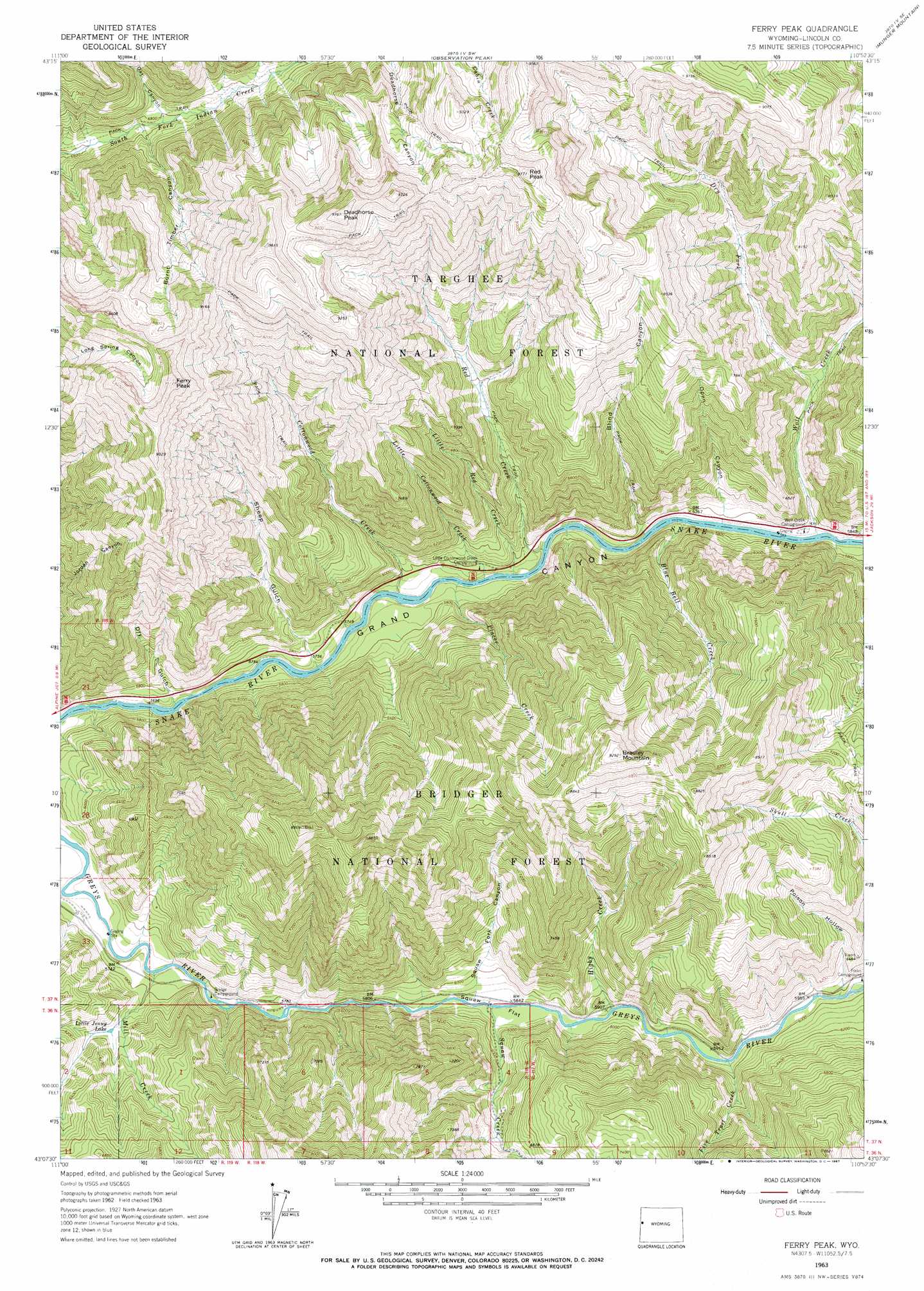
USGS Topo Quad 43110b8 - 1:24,000 scale
| Topo Map Name: | Ferry Peak |
| USGS Topo Quad ID: | 43110b8 |
| Print Size: | ca. 21 1/4" wide x 27" high |
| Southeast Coordinates: | 43.125° N latitude / 110.875° W longitude |
| Map Center Coordinates: | 43.1875° N latitude / 110.9375° W longitude |
| U.S. State: | WY |
| Filename: | o43110b8.jpg |
| Download Map JPG Image: | Ferry Peak topo map 1:24,000 scale |
| Map Type: | Topographic |
| Topo Series: | 7.5´ |
| Map Scale: | 1:24,000 |
| Source of Map Images: | United States Geological Survey (USGS) |
| Alternate Map Versions: |
Ferry Peak WY 1963, updated 1967 Download PDF Buy paper map Ferry Peak WY 1996, updated 1998 Download PDF Buy paper map Ferry Peak WY 1996, updated 1998 Download PDF Buy paper map Ferry Peak WY 2012 Download PDF Buy paper map Ferry Peak WY 2015 Download PDF Buy paper map |
| FStopo: | US Forest Service topo Ferry Peak is available: Download FStopo PDF Download FStopo TIF |
1:24,000 Topo Quads surrounding Ferry Peak
Thompson Peak |
Palisades Peak |
Teton Pass |
Jackson |
Cache Creek |
Palisades Dam |
Mount Baird |
Observation Peak |
Munger Mountain |
Camp Davis |
Poker Peak |
Alpine |
Ferry Peak |
Pine Creek |
Bailey Lake |
Tincup Mountain |
Etna |
Stewart Peak |
Deer Creek |
Pickle Pass |
Stump Peak |
Thayne West |
Thayne East |
Man Peak |
Blind Bull Creek |
> Back to 43110a1 at 1:100,000 scale
> Back to 43110a1 at 1:250,000 scale
> Back to U.S. Topo Maps home
Ferry Peak topo map: Gazetteer
Ferry Peak: Bridges
Greys River Bridge elevation 1755m 5757′Squaw Creek Bridge elevation 1778m 5833′
Ferry Peak: Flats
Squaw Flat elevation 1784m 5853′Ferry Peak: Lakes
Little Jenny Lake elevation 1817m 5961′Ferry Peak: Streams
Blue Bell Creek elevation 1740m 5708′Cottonwood Creek elevation 1725m 5659′
Dry Fork elevation 1856m 6089′
Fire Trail Creek elevation 1803m 5915′
Higby Creek elevation 1797m 5895′
Little Cottonwood Creek elevation 1723m 5652′
Little Red Creek elevation 1737m 5698′
Mill Creek elevation 1728m 5669′
Placer Creek elevation 1722m 5649′
Red Creek elevation 1726m 5662′
Squaw Creek elevation 1779m 5836′
Wolf Creek elevation 1743m 5718′
Ferry Peak: Summits
Bradley Mountain elevation 2830m 9284′Deadhorse Peak elevation 2968m 9737′
Red Peak elevation 2973m 9753′
Ferry Peak: Valleys
Blind Canyon elevation 1731m 5679′Burnt Timber Canyon elevation 2048m 6719′
Dry Gulch elevation 1727m 5666′
Oat Canyon elevation 2064m 6771′
Open Canyon elevation 1747m 5731′
Poison Hollow elevation 1820m 5971′
Sheep Gulch elevation 1721m 5646′
Squaw Fork Canyon elevation 1777m 5830′
Ferry Peak digital topo map on disk
Buy this Ferry Peak topo map showing relief, roads, GPS coordinates and other geographical features, as a high-resolution digital map file on DVD: