Upper Slide Lake Topo Map Wyoming
To zoom in, hover over the map of Upper Slide Lake
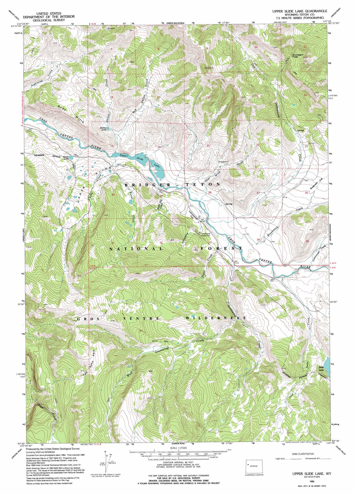
USGS Topo Quad 43110e3 - 1:24,000 scale
| Topo Map Name: | Upper Slide Lake |
| USGS Topo Quad ID: | 43110e3 |
| Print Size: | ca. 21 1/4" wide x 27" high |
| Southeast Coordinates: | 43.5° N latitude / 110.25° W longitude |
| Map Center Coordinates: | 43.5625° N latitude / 110.3125° W longitude |
| U.S. State: | WY |
| Filename: | o43110e3.jpg |
| Download Map JPG Image: | Upper Slide Lake topo map 1:24,000 scale |
| Map Type: | Topographic |
| Topo Series: | 7.5´ |
| Map Scale: | 1:24,000 |
| Source of Map Images: | United States Geological Survey (USGS) |
| Alternate Map Versions: |
Upper Slide Lake WY 1965, updated 1968 Download PDF Buy paper map Upper Slide Lake WY 1965, updated 1995 Download PDF Buy paper map Upper Slide Lake WY 1996, updated 1998 Download PDF Buy paper map Upper Slide Lake WY 2012 Download PDF Buy paper map Upper Slide Lake WY 2015 Download PDF Buy paper map |
| FStopo: | US Forest Service topo Upper Slide Lake is available: Download FStopo PDF Download FStopo TIF |
1:24,000 Topo Quads surrounding Upper Slide Lake
Moran |
Davis Hill |
Rosies Ridge |
Angle Mountain |
Togwotee Pass |
Shadow Mountain |
Mount Leidy |
Green Mountain |
Tripod Peak |
Lava Mountain |
Blue Miner Lake |
Grizzly Lake |
Upper Slide Lake |
Burnt Mountain |
Sheridan Pass |
Turquoise Lake |
Crystal Peak |
Darwin Peak |
Ouzel Falls |
Mosquito Lake |
Bull Creek |
Granite Falls |
Doubletop Peak |
Tosi Peak |
Klondike Hill |
> Back to 43110e1 at 1:100,000 scale
> Back to 43110a1 at 1:250,000 scale
> Back to U.S. Topo Maps home
Upper Slide Lake topo map: Gazetteer
Upper Slide Lake: Flats
Breakneck Flat elevation 2380m 7808′Two Echo Park elevation 2858m 9376′
Upper Slide elevation 2341m 7680′
Yellowjacket Flat elevation 2254m 7395′
Upper Slide Lake: Gaps
Gunsight Pass elevation 2809m 9215′Upper Slide Lake: Lakes
Dallas Lake elevation 2274m 7460′Goose Lake elevation 2274m 7460′
Soda Lake elevation 2382m 7814′
Upper Slide Lake elevation 2217m 7273′
Upper Slide Lake: Mines
Iter Gross Ventre Mine elevation 2247m 7372′Upper Slide Lake: Ridges
Gray Hills elevation 2459m 8067′Upper Slide Lake: Streams
Breakneck Creek elevation 2237m 7339′Burnt Creek elevation 2233m 7326′
Cottonwood Creek elevation 2257m 7404′
Dallas Creek elevation 2222m 7290′
Devils Dip Creek elevation 2220m 7283′
Dry Cottonwood Creek elevation 2232m 7322′
Dry Dallas Creek elevation 2250m 7381′
Goosewing Creek elevation 2239m 7345′
Lake Creek elevation 2217m 7273′
Soda Creek elevation 2252m 7388′
Tepee Creek elevation 2238m 7342′
West Goosewing Creek elevation 2298m 7539′
Yellowjacket Creek elevation 2229m 7312′
Upper Slide Lake: Valleys
Coal Mine Draw elevation 2228m 7309′Upper Slide Lake digital topo map on disk
Buy this Upper Slide Lake topo map showing relief, roads, GPS coordinates and other geographical features, as a high-resolution digital map file on DVD: