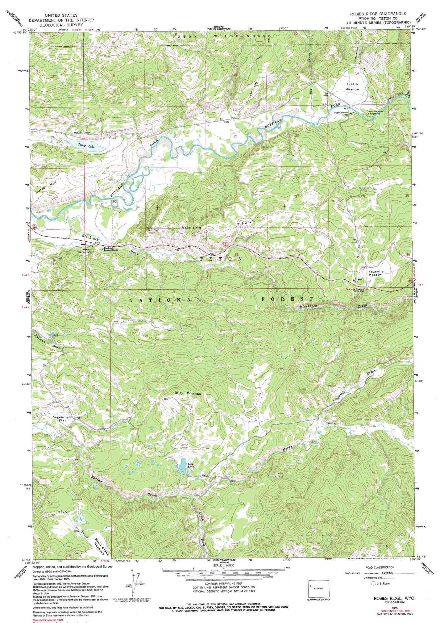
Rosies Ridge Topo Map Wyoming
To zoom in, hover over the map of Rosies Ridge
USGS Topo Quad 43110g3 - 1:24,000 scale
| Topo Map Name: | Rosies Ridge |
| USGS Topo Quad ID: | 43110g3 |
| Print Size: | ca. 21 1/4" wide x 27" high |
| Southeast Coordinates: | 43.75° N latitude / 110.25° W longitude |
| Map Center Coordinates: | 43.8125° N latitude / 110.3125° W longitude |
| U.S. State: | WY |
| Filename: | o43110g3.jpg |
| Download Map JPG Image: | Rosies Ridge topo map 1:24,000 scale |
| Map Type: | Topographic |
| Topo Series: | 7.5´ |
| Map Scale: | 1:24,000 |
| Source of Map Images: | United States Geological Survey (USGS) |
| Alternate Map Versions: |
Rosies Ridge WY 1965, updated 1968 Download PDF Buy paper map Rosies Ridge WY 1965, updated 1991 Download PDF Buy paper map Rosies Ridge WY 1996, updated 1998 Download PDF Buy paper map Rosies Ridge WY 2012 Download PDF Buy paper map Rosies Ridge WY 2015 Download PDF Buy paper map |
| FStopo: | US Forest Service topo Rosies Ridge is available: Download FStopo PDF Download FStopo TIF |
1:24,000 Topo Quads surrounding Rosies Ridge
Huckleberry Mountain |
Bobcat Ridge |
Gravel Peak |
Two Ocean Pass |
Yellowstone Point |
Two Ocean Lake |
Whetstone Mountain |
Hunter Mountain |
Joy Peak |
Crater Lake |
Moran |
Davis Hill |
Rosies Ridge |
Angle Mountain |
Togwotee Pass |
Shadow Mountain |
Mount Leidy |
Green Mountain |
Tripod Peak |
Lava Mountain |
Blue Miner Lake |
Grizzly Lake |
Upper Slide Lake |
Burnt Mountain |
Sheridan Pass |
> Back to 43110e1 at 1:100,000 scale
> Back to 43110a1 at 1:250,000 scale
> Back to U.S. Topo Maps home
Rosies Ridge topo map: Gazetteer
Rosies Ridge: Dams
Tracy Lake Dam elevation 2106m 6909′Rosies Ridge: Flats
Fourmile Meadow elevation 2398m 7867′Preacher Park elevation 2494m 8182′
Sagebrush Flat elevation 2352m 7716′
Skull Creek Meadows elevation 2475m 8120′
Turpin Meadow elevation 2114m 6935′
Rosies Ridge: Lakes
Lily Lake elevation 2455m 8054′Marys Lake elevation 2341m 7680′
Tracy Lake elevation 2131m 6991′
Rosies Ridge: Reservoirs
Tracy Lake elevation 2106m 6909′Rosies Ridge: Ridges
Rosies Ridge elevation 2367m 7765′Rosies Ridge: Streams
Blackrock Creek elevation 2081m 6827′Box Creek elevation 2104m 6902′
Flagstaff Creek elevation 2497m 8192′
North Fork Spread Creek elevation 2376m 7795′
South Fork Spread Creek elevation 2371m 7778′
Rosies Ridge: Summits
Baldy Mountain elevation 2598m 8523′Burro Hill elevation 2209m 7247′
Rosies Ridge: Trails
Clear Creek Trail elevation 2336m 7664′Rosies Ridge digital topo map on disk
Buy this Rosies Ridge topo map showing relief, roads, GPS coordinates and other geographical features, as a high-resolution digital map file on DVD: