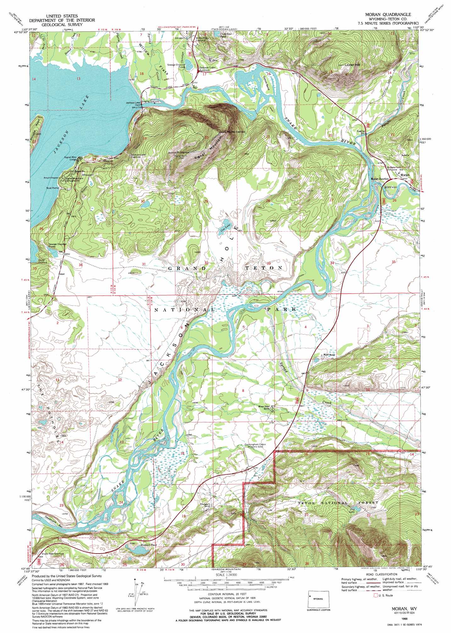
Moran Topo Map Wyoming
To zoom in, hover over the map of Moran
USGS Topo Quad 43110g5 - 1:24,000 scale
| Topo Map Name: | Moran |
| USGS Topo Quad ID: | 43110g5 |
| Print Size: | ca. 21 1/4" wide x 27" high |
| Southeast Coordinates: | 43.75° N latitude / 110.5° W longitude |
| Map Center Coordinates: | 43.8125° N latitude / 110.5625° W longitude |
| U.S. State: | WY |
| Filename: | o43110g5.jpg |
| Download Map JPG Image: | Moran topo map 1:24,000 scale |
| Map Type: | Topographic |
| Topo Series: | 7.5´ |
| Map Scale: | 1:24,000 |
| Source of Map Images: | United States Geological Survey (USGS) |
| Alternate Map Versions: |
Moran WY 1968, updated 1972 Download PDF Buy paper map Moran WY 1968, updated 1995 Download PDF Buy paper map Moran WY 1996, updated 1998 Download PDF Buy paper map Moran WY 2012 Download PDF Buy paper map Moran WY 2015 Download PDF Buy paper map |
| FStopo: | US Forest Service topo Moran is available: Download FStopo PDF Download FStopo TIF |
1:24,000 Topo Quads surrounding Moran
Survey Peak |
Flagg Ranch |
Huckleberry Mountain |
Bobcat Ridge |
Gravel Peak |
Ranger Peak |
Colter Bay |
Two Ocean Lake |
Whetstone Mountain |
Hunter Mountain |
Mount Moran |
Jenny Lake |
Moran |
Davis Hill |
Rosies Ridge |
Grand Teton |
Moose |
Shadow Mountain |
Mount Leidy |
Green Mountain |
Teton Village |
Gros Ventre Junction |
Blue Miner Lake |
Grizzly Lake |
Upper Slide Lake |
> Back to 43110e1 at 1:100,000 scale
> Back to 43110a1 at 1:250,000 scale
> Back to U.S. Topo Maps home
Moran topo map: Gazetteer
Moran: Areas
The Potholes elevation 2057m 6748′Moran: Bars
Deadmans Bar elevation 2022m 6633′Moran: Dams
Jackson Lake Dam elevation 2065m 6774′Moran: Flats
Buffalo Meadow elevation 2057m 6748′Moran: Islands
Oxbow Bend elevation 2053m 6735′Moran: Lakes
Cow Lake elevation 2085m 6840′Dry Lake elevation 2249m 7378′
Hedrick Pond elevation 2049m 6722′
Moran: Mines
Cowboy Lode Mine elevation 2052m 6732′Moran: Populated Places
Elk elevation 2068m 6784′Moran elevation 2057m 6748′
Moran: Reservoirs
Jackson Lake elevation 2065m 6774′Moran: Streams
Buffalo Fork elevation 2050m 6725′Christian Creek elevation 2054m 6738′
Pacific Creek elevation 2050m 6725′
Pilgrim Creek elevation 2066m 6778′
Second Creek elevation 2066m 6778′
Spread Creek elevation 2044m 6706′
Spring Creek elevation 2056m 6745′
Third Creek elevation 2066m 6778′
Moran: Summits
Lozier Hill elevation 2331m 7647′Signal Mountain elevation 2354m 7723′
Moran digital topo map on disk
Buy this Moran topo map showing relief, roads, GPS coordinates and other geographical features, as a high-resolution digital map file on DVD: