Two Ocean Lake Topo Map Wyoming
To zoom in, hover over the map of Two Ocean Lake
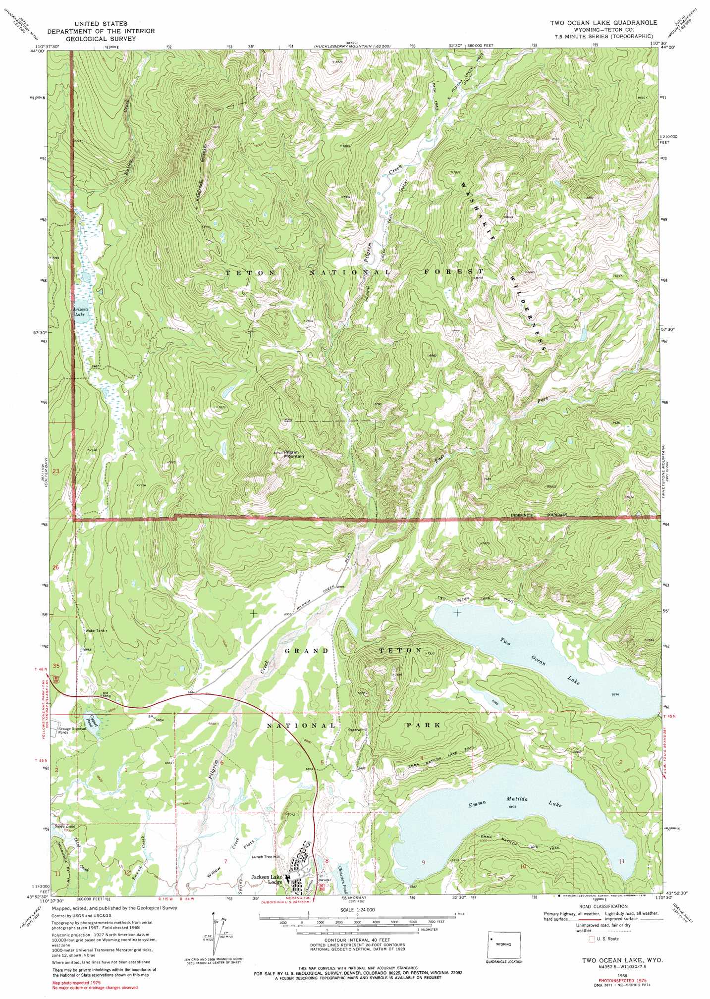
USGS Topo Quad 43110h5 - 1:24,000 scale
| Topo Map Name: | Two Ocean Lake |
| USGS Topo Quad ID: | 43110h5 |
| Print Size: | ca. 21 1/4" wide x 27" high |
| Southeast Coordinates: | 43.875° N latitude / 110.5° W longitude |
| Map Center Coordinates: | 43.9375° N latitude / 110.5625° W longitude |
| U.S. State: | WY |
| Filename: | o43110h5.jpg |
| Download Map JPG Image: | Two Ocean Lake topo map 1:24,000 scale |
| Map Type: | Topographic |
| Topo Series: | 7.5´ |
| Map Scale: | 1:24,000 |
| Source of Map Images: | United States Geological Survey (USGS) |
| Alternate Map Versions: |
Two Ocean Lake WY 1968, updated 1971 Download PDF Buy paper map Two Ocean Lake WY 1968, updated 1979 Download PDF Buy paper map Two Ocean Lake WY 1996, updated 1998 Download PDF Buy paper map Two Ocean Lake WY 2012 Download PDF Buy paper map Two Ocean Lake WY 2015 Download PDF Buy paper map |
| FStopo: | US Forest Service topo Two Ocean Lake is available: Download FStopo PDF Download FStopo TIF |
1:24,000 Topo Quads surrounding Two Ocean Lake
Grassy Lake Reservoir |
Lewis Canyon |
Snake Hot Springs |
Mount Hancock |
Crooked Creek |
Survey Peak |
Flagg Ranch |
Huckleberry Mountain |
Bobcat Ridge |
Gravel Peak |
Ranger Peak |
Colter Bay |
Two Ocean Lake |
Whetstone Mountain |
Hunter Mountain |
Mount Moran |
Jenny Lake |
Moran |
Davis Hill |
Rosies Ridge |
Grand Teton |
Moose |
Shadow Mountain |
Mount Leidy |
Green Mountain |
> Back to 43110e1 at 1:100,000 scale
> Back to 43110a1 at 1:250,000 scale
> Back to U.S. Topo Maps home
Two Ocean Lake topo map: Gazetteer
Two Ocean Lake: Lakes
Arizona Lake elevation 2121m 6958′Christian Pond elevation 2085m 6840′
Cygnet Pond elevation 2085m 6840′
Emma Matilda Lake elevation 2096m 6876′
Two Ocean Lake elevation 2103m 6899′
Two Ocean Lake: Streams
East Fork Pilgrim Creek elevation 2132m 6994′Two Ocean Lake: Summits
Grand View Point elevation 2282m 7486′Lunch Tree Hill elevation 2125m 6971′
Pilgrim Mountain elevation 2517m 8257′
Two Ocean Lake: Trails
Emma Matilda Lake Trail elevation 2138m 7014′Hermitage Point Trail elevation 2074m 6804′
Two Ocean Lake Trail elevation 2114m 6935′
Two Ocean Lake digital topo map on disk
Buy this Two Ocean Lake topo map showing relief, roads, GPS coordinates and other geographical features, as a high-resolution digital map file on DVD: