Meadow Creek Mountain Topo Map Idaho
To zoom in, hover over the map of Meadow Creek Mountain
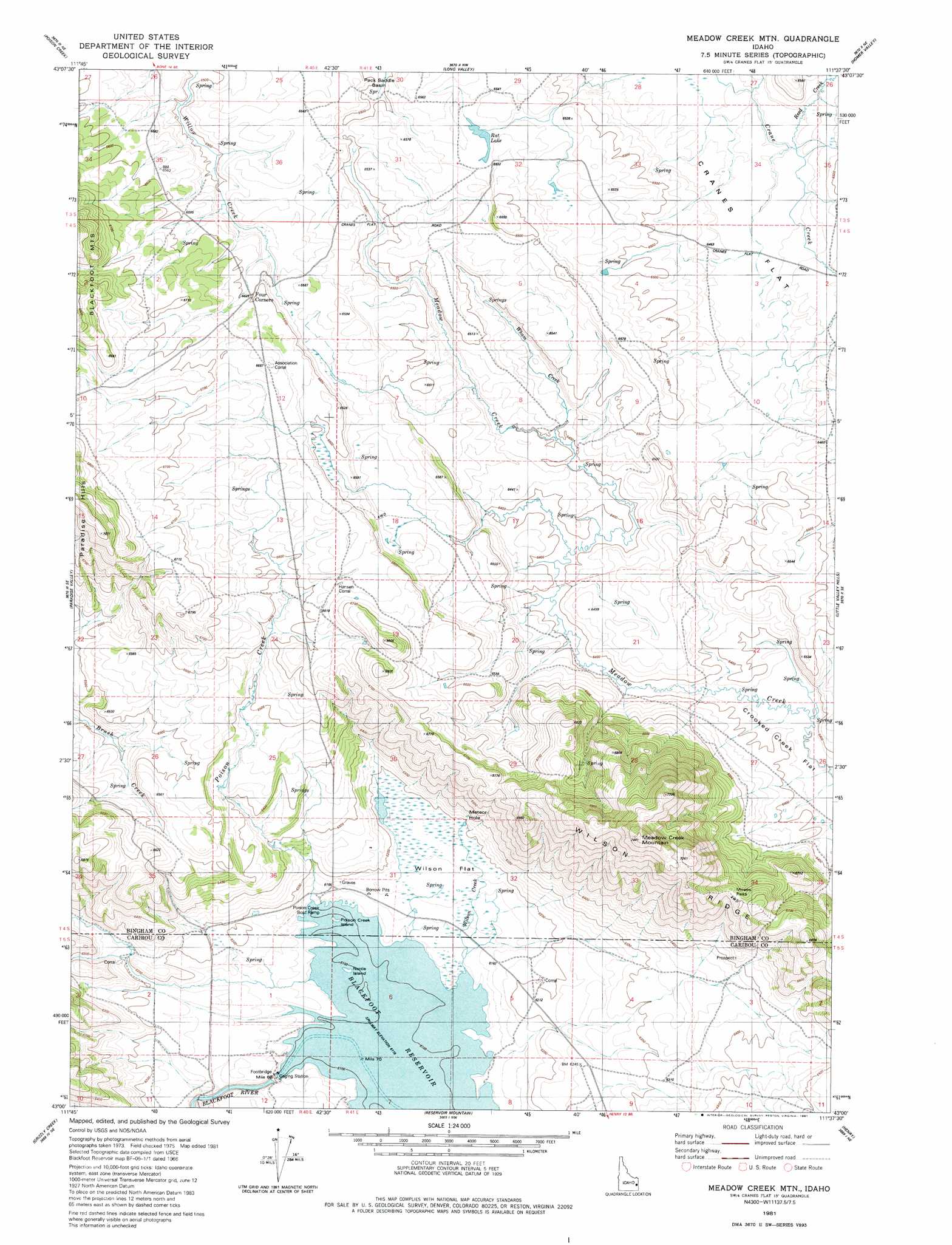
USGS Topo Quad 43111a6 - 1:24,000 scale
| Topo Map Name: | Meadow Creek Mountain |
| USGS Topo Quad ID: | 43111a6 |
| Print Size: | ca. 21 1/4" wide x 27" high |
| Southeast Coordinates: | 43° N latitude / 111.625° W longitude |
| Map Center Coordinates: | 43.0625° N latitude / 111.6875° W longitude |
| U.S. State: | ID |
| Filename: | o43111a6.jpg |
| Download Map JPG Image: | Meadow Creek Mountain topo map 1:24,000 scale |
| Map Type: | Topographic |
| Topo Series: | 7.5´ |
| Map Scale: | 1:24,000 |
| Source of Map Images: | United States Geological Survey (USGS) |
| Alternate Map Versions: |
Meadow Creek Mtn ID 1981, updated 1981 Download PDF Buy paper map Meadow Creek Mountain ID 2010 Download PDF Buy paper map Meadow Creek Mountain ID 2013 Download PDF Buy paper map |
1:24,000 Topo Quads surrounding Meadow Creek Mountain
Wolverine |
Bone |
Jumpoff Hill |
Castle Rock |
Commissary Ridge |
Miner Creek |
Poison Creek |
Long Valley |
Homer Valley |
Herman |
Dunn Basin |
Paradise Valley |
Meadow Creek Mountain |
Little Valley Hills |
Bear Island |
Chesterfield Res |
Grizzly Creek |
Reservoir Mountain |
Henry |
Wayan West |
Chesterfield |
Hatch |
The Dip |
China Hat |
Lower Valley |
> Back to 43111a1 at 1:100,000 scale
> Back to 43110a1 at 1:250,000 scale
> Back to U.S. Topo Maps home
Meadow Creek Mountain topo map: Gazetteer
Meadow Creek Mountain: Crossings
Four Corners elevation 2013m 6604′Meadow Creek Mountain: Dams
Blackfoot Dam elevation 1877m 6158′Meadow Creek Mountain: Flats
Cranes Flat elevation 1967m 6453′Wilson Flat elevation 1885m 6184′
Meadow Creek Mountain: Gaps
Moses Pass elevation 2061m 6761′Meadow Creek Mountain: Islands
Nettle Island elevation 1866m 6122′Poison Creek Island elevation 1867m 6125′
Meadow Creek Mountain: Lakes
Meteor Hole elevation 1906m 6253′Rat Lake elevation 1992m 6535′
Meadow Creek Mountain: Lavas
Willow Creek Lava Field elevation 1995m 6545′Meadow Creek Mountain: Reservoirs
Blackfoot Reservoir elevation 1867m 6125′Meadow Creek Mountain: Ridges
Wilson Ridge elevation 2084m 6837′Meadow Creek Mountain: Streams
Poison Creek elevation 1927m 6322′Reed Creek elevation 1968m 6456′
Wham Creek elevation 1952m 6404′
Wilson Creek elevation 1867m 6125′
Wilson Creek elevation 1866m 6122′
Meadow Creek Mountain: Summits
Meadow Creek Mountain elevation 2264m 7427′Meadow Creek Mountain digital topo map on disk
Buy this Meadow Creek Mountain topo map showing relief, roads, GPS coordinates and other geographical features, as a high-resolution digital map file on DVD: