Palisades Dam Topo Map Idaho
To zoom in, hover over the map of Palisades Dam
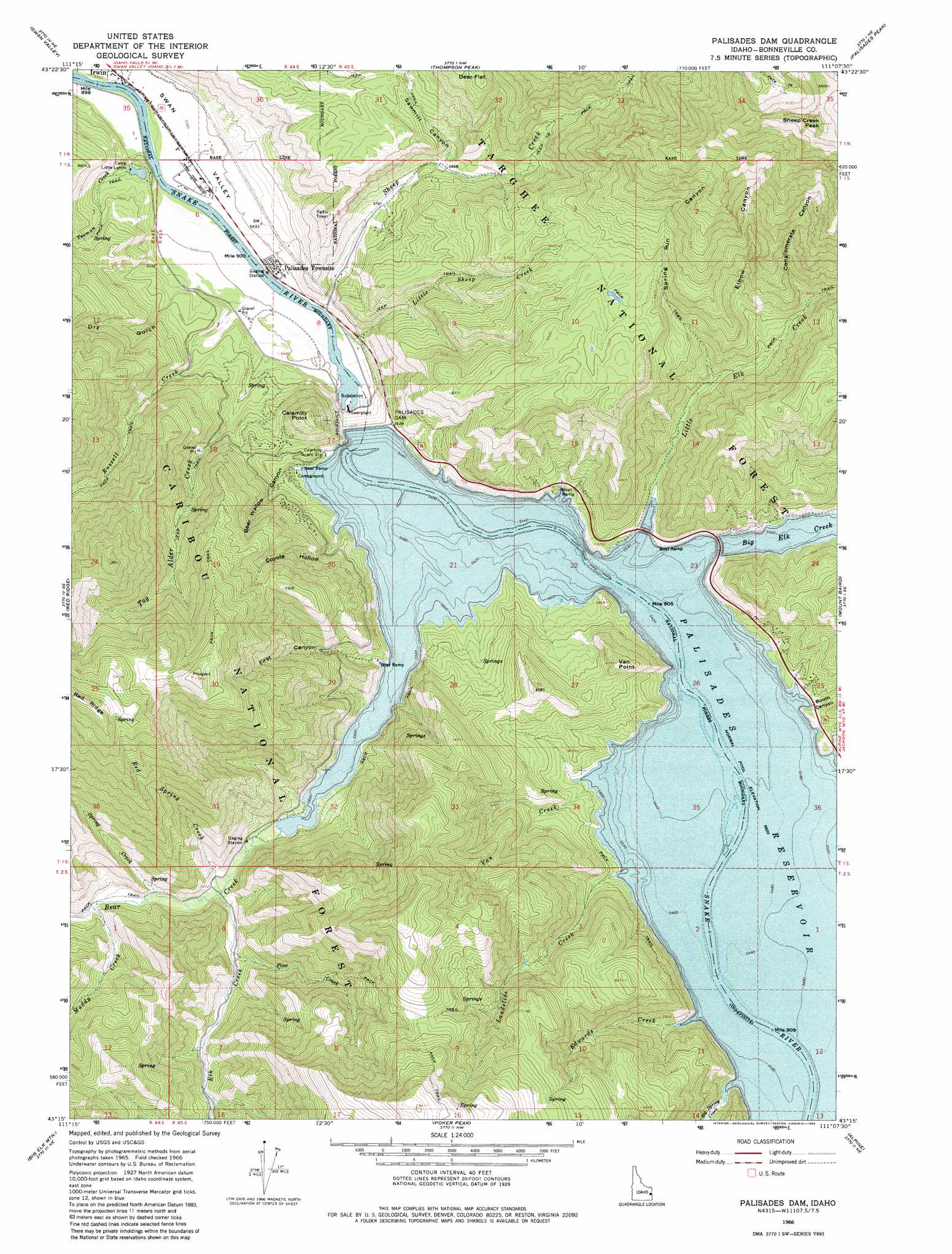
USGS Topo Quad 43111c2 - 1:24,000 scale
| Topo Map Name: | Palisades Dam |
| USGS Topo Quad ID: | 43111c2 |
| Print Size: | ca. 21 1/4" wide x 27" high |
| Southeast Coordinates: | 43.25° N latitude / 111.125° W longitude |
| Map Center Coordinates: | 43.3125° N latitude / 111.1875° W longitude |
| U.S. State: | ID |
| Filename: | o43111c2.jpg |
| Download Map JPG Image: | Palisades Dam topo map 1:24,000 scale |
| Map Type: | Topographic |
| Topo Series: | 7.5´ |
| Map Scale: | 1:24,000 |
| Source of Map Images: | United States Geological Survey (USGS) |
| Alternate Map Versions: |
Palisades Dam ID 1966, updated 1969 Download PDF Buy paper map Palisades Dam ID 1966, updated 1983 Download PDF Buy paper map Palisades Dam ID 1966, updated 1983 Download PDF Buy paper map Palisades Dam ID 2011 Download PDF Buy paper map Palisades Dam ID 2013 Download PDF Buy paper map |
| FStopo: | US Forest Service topo Palisades Dam is available: Download FStopo PDF Download FStopo TIF |
1:24,000 Topo Quads surrounding Palisades Dam
Wheaton Mountain |
Stouts Mountain |
Fourth Of July Peak |
Victor |
Rendezvous Peak |
Conant Valley |
Swan Valley |
Thompson Peak |
Palisades Peak |
Teton Pass |
Commissary Ridge |
Red Ridge |
Palisades Dam |
Mount Baird |
Observation Peak |
Herman |
Big Elk Mountain |
Poker Peak |
Alpine |
Ferry Peak |
Bear Island |
Caribou Mountain |
Tincup Mountain |
Etna |
Stewart Peak |
> Back to 43111a1 at 1:100,000 scale
> Back to 43110a1 at 1:250,000 scale
> Back to U.S. Topo Maps home
Palisades Dam topo map: Gazetteer
Palisades Dam: Dams
Palisades Dam elevation 1708m 5603′Palisades Dam: Flats
Deer Flat elevation 2152m 7060′Palisades Dam: Populated Places
Palisades elevation 1644m 5393′Palisades Dam: Reservoirs
Palisades Reservoir elevation 1708m 5603′Palisades Reservoir elevation 1684m 5524′
Palisades Dam: Streams
Bear Creek elevation 1714m 5623′Big Spring Creek elevation 1717m 5633′
Edwards Creek elevation 1718m 5636′
Elbow Creek elevation 1865m 6118′
Elk Creek elevation 1726m 5662′
Landslide Creek elevation 1717m 5633′
Little Elk Creek elevation 1716m 5629′
Little Sheep Creek elevation 1642m 5387′
Muddy Creek elevation 1744m 5721′
Palisades Creek elevation 1633m 5357′
Pine Creek elevation 1757m 5764′
Red Spring Creek elevation 1725m 5659′
Russell Creek elevation 1665m 5462′
Sheep Creek elevation 1645m 5396′
Spring Creek elevation 1742m 5715′
Tag Alder Creek elevation 1670m 5479′
Van Creek elevation 1715m 5626′
Yeaman Creek elevation 1637m 5370′
Palisades Dam: Summits
Calamity Point elevation 1978m 6489′Sheep Creek Peak elevation 3022m 9914′
Van Point elevation 1944m 6377′
Palisades Dam: Valleys
Bear Wallow Canyon elevation 1743m 5718′Booth Canyon elevation 1722m 5649′
Conglomerate Canyon elevation 1985m 6512′
Coyote Hollow elevation 1715m 5626′
Dry Gulch elevation 1685m 5528′
Elbow Canyon elevation 1879m 6164′
First Canyon elevation 1714m 5623′
Sawmill Canyon elevation 1799m 5902′
Spring Run Canyon elevation 1818m 5964′
Palisades Dam digital topo map on disk
Buy this Palisades Dam topo map showing relief, roads, GPS coordinates and other geographical features, as a high-resolution digital map file on DVD: