Wheaton Mountain Topo Map Idaho
To zoom in, hover over the map of Wheaton Mountain
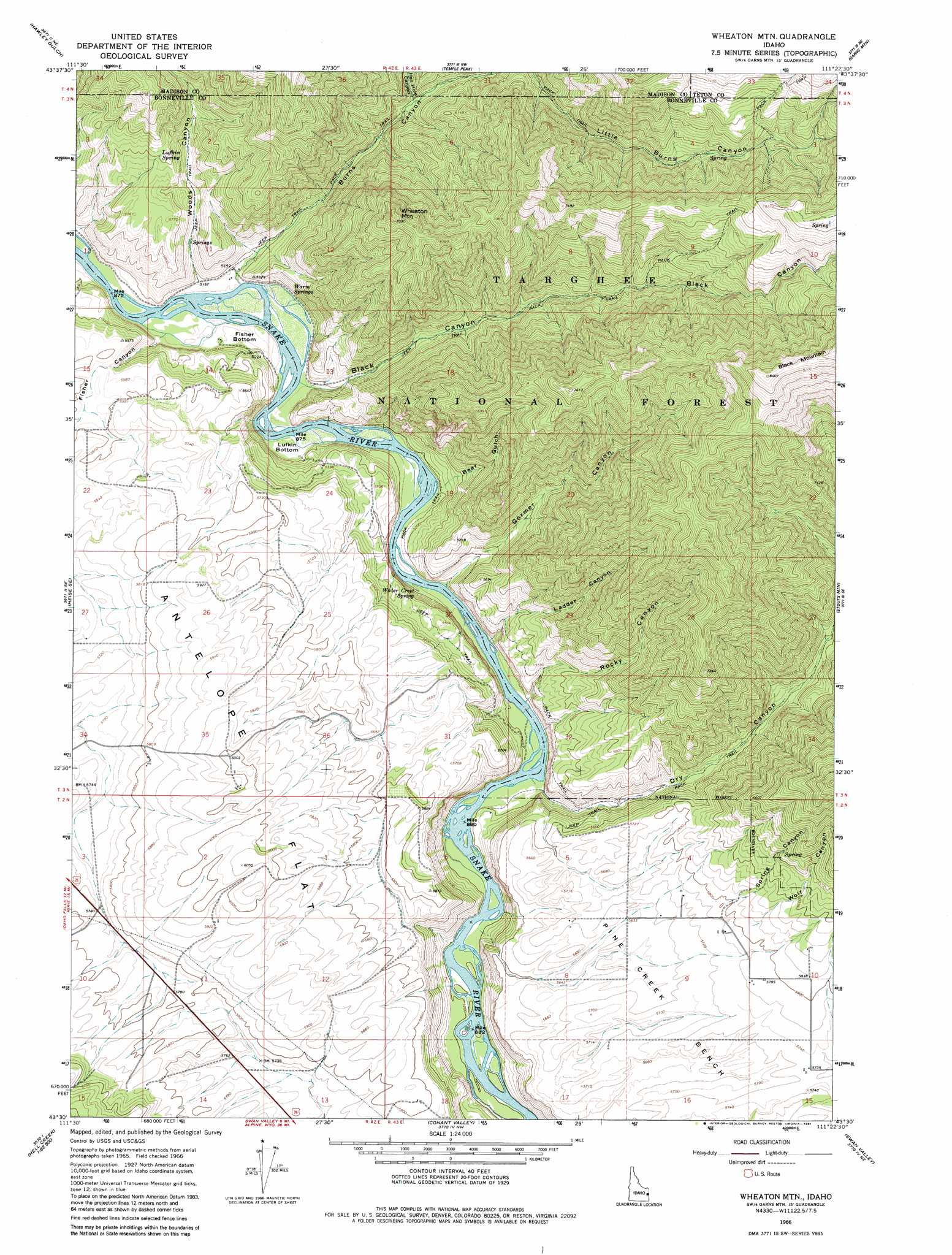
USGS Topo Quad 43111e4 - 1:24,000 scale
| Topo Map Name: | Wheaton Mountain |
| USGS Topo Quad ID: | 43111e4 |
| Print Size: | ca. 21 1/4" wide x 27" high |
| Southeast Coordinates: | 43.5° N latitude / 111.375° W longitude |
| Map Center Coordinates: | 43.5625° N latitude / 111.4375° W longitude |
| U.S. State: | ID |
| Filename: | o43111e4.jpg |
| Download Map JPG Image: | Wheaton Mountain topo map 1:24,000 scale |
| Map Type: | Topographic |
| Topo Series: | 7.5´ |
| Map Scale: | 1:24,000 |
| Source of Map Images: | United States Geological Survey (USGS) |
| Alternate Map Versions: |
Wheaton Mountain ID 1966, updated 1969 Download PDF Buy paper map Wheaton Mountain ID 1966, updated 1981 Download PDF Buy paper map Wheaton Mountain ID 1966, updated 1981 Download PDF Buy paper map Wheaton Mountain ID 2011 Download PDF Buy paper map Wheaton Mountain ID 2013 Download PDF Buy paper map |
| FStopo: | US Forest Service topo Wheaton Mountain is available: Download FStopo PDF Download FStopo TIF |
1:24,000 Topo Quads surrounding Wheaton Mountain
Moody |
White Owl Butte |
Wright Creek |
Packsaddle Lake |
Tetonia |
Heise |
Hawley Gulch |
Temple Peak |
Garns Mountain |
Bates |
Poplar |
Heise Se |
Wheaton Mountain |
Stouts Mountain |
Fourth Of July Peak |
Lone Pine Ridge |
Point Lookout |
Conant Valley |
Swan Valley |
Thompson Peak |
Jumpoff Hill |
Castle Rock |
Commissary Ridge |
Red Ridge |
Palisades Dam |
> Back to 43111e1 at 1:100,000 scale
> Back to 43110a1 at 1:250,000 scale
> Back to U.S. Topo Maps home
Wheaton Mountain topo map: Gazetteer
Wheaton Mountain: Bends
Fisher Bottom elevation 1562m 5124′Lufkin Bottom elevation 1565m 5134′
Wheaton Mountain: Flats
Antelope Flat elevation 1818m 5964′Wheaton Mountain: Springs
Lufkin Spring elevation 1770m 5807′Warm Springs elevation 1570m 5150′
Water Crest Spring elevation 1569m 5147′
Wheaton Mountain: Streams
Jensen Creek elevation 1702m 5583′Woods Creek elevation 1576m 5170′
Wheaton Mountain: Summits
Wheaton Mountain elevation 2142m 7027′Wheaton Mountain: Valleys
Bear Gulch elevation 1569m 5147′Black Canyon elevation 1564m 5131′
Burns Canyon elevation 1562m 5124′
Diamond X Canyon elevation 1793m 5882′
Dry Canyon elevation 1577m 5173′
Fisher Canyon elevation 1557m 5108′
Gormer Canyon elevation 1567m 5141′
Hell Hole Canyon elevation 1664m 5459′
Ladder Canyon elevation 1566m 5137′
Rocky Canyon elevation 1572m 5157′
Spring Canyon elevation 1767m 5797′
Wolf Canyon elevation 1777m 5830′
Woods Canyon elevation 1581m 5187′
Wheaton Mountain digital topo map on disk
Buy this Wheaton Mountain topo map showing relief, roads, GPS coordinates and other geographical features, as a high-resolution digital map file on DVD: