Heise Se Topo Map Idaho
To zoom in, hover over the map of Heise Se
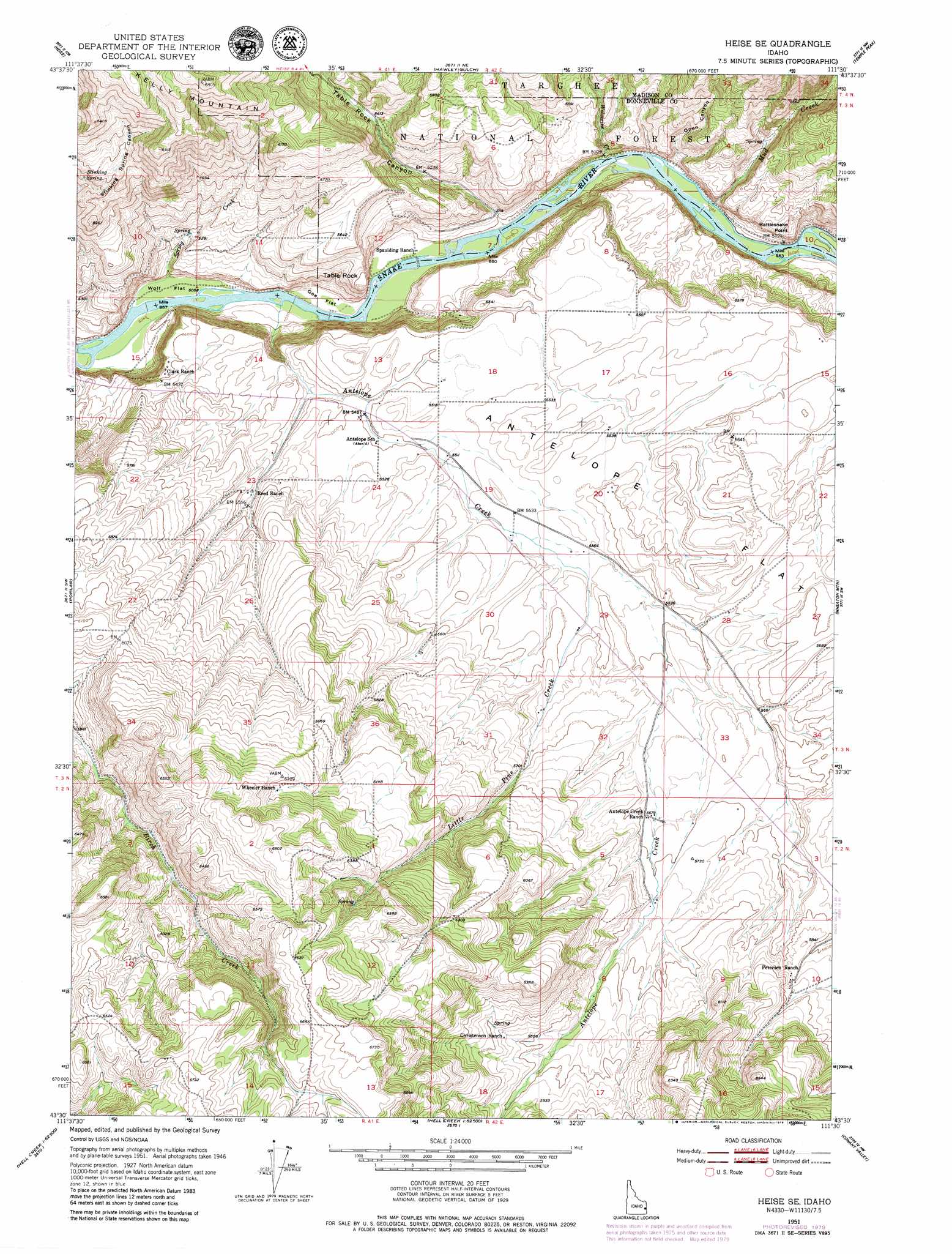
USGS Topo Quad 43111e5 - 1:24,000 scale
| Topo Map Name: | Heise Se |
| USGS Topo Quad ID: | 43111e5 |
| Print Size: | ca. 21 1/4" wide x 27" high |
| Southeast Coordinates: | 43.5° N latitude / 111.5° W longitude |
| Map Center Coordinates: | 43.5625° N latitude / 111.5625° W longitude |
| U.S. State: | ID |
| Filename: | o43111e5.jpg |
| Download Map JPG Image: | Heise Se topo map 1:24,000 scale |
| Map Type: | Topographic |
| Topo Series: | 7.5´ |
| Map Scale: | 1:24,000 |
| Source of Map Images: | United States Geological Survey (USGS) |
| Alternate Map Versions: |
Heise SE ID 1951, updated 1952 Download PDF Buy paper map Heise SE ID 1951, updated 1965 Download PDF Buy paper map Heise SE ID 1951, updated 1979 Download PDF Buy paper map Heise SE ID 1951, updated 1979 Download PDF Buy paper map Heise SE ID 2011 Download PDF Buy paper map Heise SE ID 2013 Download PDF Buy paper map |
| FStopo: | US Forest Service topo Heise SE is available: Download FStopo PDF Download FStopo TIF |
1:24,000 Topo Quads surrounding Heise Se
Rexburg |
Moody |
White Owl Butte |
Wright Creek |
Packsaddle Lake |
Ririe |
Heise |
Hawley Gulch |
Temple Peak |
Garns Mountain |
Rigby Se |
Poplar |
Heise Se |
Wheaton Mountain |
Stouts Mountain |
Ozone |
Lone Pine Ridge |
Point Lookout |
Conant Valley |
Swan Valley |
Bone |
Jumpoff Hill |
Castle Rock |
Commissary Ridge |
Red Ridge |
> Back to 43111e1 at 1:100,000 scale
> Back to 43110a1 at 1:250,000 scale
> Back to U.S. Topo Maps home
Heise Se topo map: Gazetteer
Heise Se: Cliffs
Rattlesnake Point elevation 1636m 5367′Heise Se: Flats
Antelope Flat elevation 1703m 5587′Goe Flat elevation 1546m 5072′
Wolf Flat elevation 1540m 5052′
Heise Se: Pillars
Table Rock elevation 1679m 5508′Heise Se: Springs
Stinking Spring elevation 1747m 5731′Heise Se: Streams
Antelope Creek elevation 1541m 5055′Little Pine Creek elevation 1688m 5538′
Mud Creek elevation 1555m 5101′
Spring Creek elevation 1540m 5052′
Wolverine Creek elevation 1550m 5085′
Heise Se: Summits
Kelly Mountain elevation 2071m 6794′Heise Se: Valleys
Open Canyon elevation 1553m 5095′Table Rock Canyon elevation 1549m 5082′
Heise Se digital topo map on disk
Buy this Heise Se topo map showing relief, roads, GPS coordinates and other geographical features, as a high-resolution digital map file on DVD: