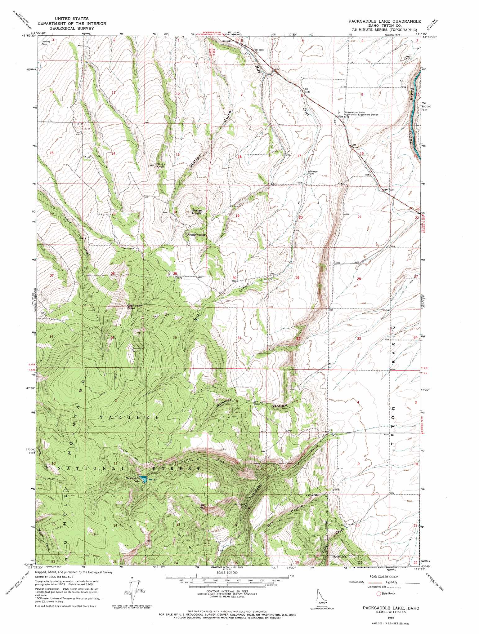
Packsaddle Lake Topo Map Idaho
To zoom in, hover over the map of Packsaddle Lake
USGS Topo Quad 43111g3 - 1:24,000 scale
| Topo Map Name: | Packsaddle Lake |
| USGS Topo Quad ID: | 43111g3 |
| Print Size: | ca. 21 1/4" wide x 27" high |
| Southeast Coordinates: | 43.75° N latitude / 111.25° W longitude |
| Map Center Coordinates: | 43.8125° N latitude / 111.3125° W longitude |
| U.S. State: | ID |
| Filename: | o43111g3.jpg |
| Download Map JPG Image: | Packsaddle Lake topo map 1:24,000 scale |
| Map Type: | Topographic |
| Topo Series: | 7.5´ |
| Map Scale: | 1:24,000 |
| Source of Map Images: | United States Geological Survey (USGS) |
| Alternate Map Versions: |
Packsaddle Lake ID 1965, updated 1967 Download PDF Buy paper map Packsaddle Lake ID 1965, updated 1980 Download PDF Buy paper map Packsaddle Lake ID 2011 Download PDF Buy paper map Packsaddle Lake ID 2013 Download PDF Buy paper map |
| FStopo: | US Forest Service topo Packsaddle Lake is available: Download FStopo PDF Download FStopo TIF |
1:24,000 Topo Quads surrounding Packsaddle Lake
Lemon Lake |
Ashton |
Warm River |
Porcupine Lake |
Sheep Falls |
Newdale |
Linderman Dam |
Drummond |
Lamont |
Mcrenolds Reservoir |
White Owl Butte |
Wright Creek |
Packsaddle Lake |
Tetonia |
Clawson |
Hawley Gulch |
Temple Peak |
Garns Mountain |
Bates |
Driggs |
Heise Se |
Wheaton Mountain |
Stouts Mountain |
Fourth Of July Peak |
Victor |
> Back to 43111e1 at 1:100,000 scale
> Back to 43110a1 at 1:250,000 scale
> Back to U.S. Topo Maps home
Packsaddle Lake topo map: Gazetteer
Packsaddle Lake: Cliffs
Grandview Point elevation 2331m 7647′Packsaddle Lake: Lakes
Packsaddle Lake elevation 2249m 7378′Packsaddle Lake: Springs
Neville Spring elevation 2038m 6686′Packsaddle Lake: Streams
Dude Creek elevation 1861m 6105′North Fork Packsaddle Creek elevation 1938m 6358′
Packsaddle Lake: Summits
Baldy Knoll elevation 2069m 6788′Susies Nipple elevation 2096m 6876′
Packsaddle Lake: Valleys
Rammell Hollow elevation 1871m 6138′Station Gulch elevation 1830m 6003′
Packsaddle Lake digital topo map on disk
Buy this Packsaddle Lake topo map showing relief, roads, GPS coordinates and other geographical features, as a high-resolution digital map file on DVD: