Menan Buttes Topo Map Idaho
To zoom in, hover over the map of Menan Buttes
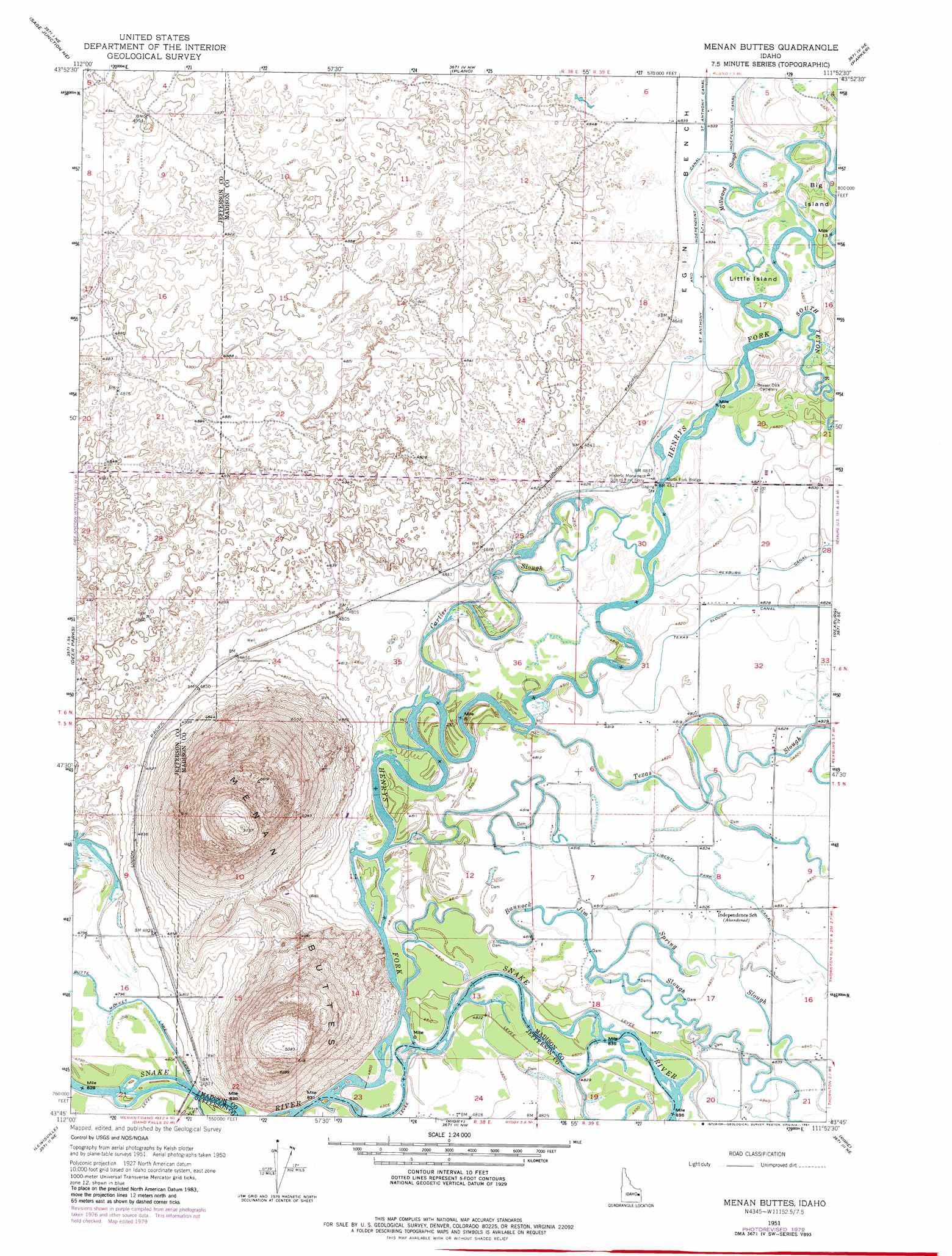
USGS Topo Quad 43111g8 - 1:24,000 scale
| Topo Map Name: | Menan Buttes |
| USGS Topo Quad ID: | 43111g8 |
| Print Size: | ca. 21 1/4" wide x 27" high |
| Southeast Coordinates: | 43.75° N latitude / 111.875° W longitude |
| Map Center Coordinates: | 43.8125° N latitude / 111.9375° W longitude |
| U.S. State: | ID |
| Filename: | o43111g8.jpg |
| Download Map JPG Image: | Menan Buttes topo map 1:24,000 scale |
| Map Type: | Topographic |
| Topo Series: | 7.5´ |
| Map Scale: | 1:24,000 |
| Source of Map Images: | United States Geological Survey (USGS) |
| Alternate Map Versions: |
Menan Buttes ID 1951, updated 1953 Download PDF Buy paper map Menan Buttes ID 1951, updated 1953 Download PDF Buy paper map Menan Buttes ID 1951, updated 1953 Download PDF Buy paper map Menan Buttes ID 1951, updated 1955 Download PDF Buy paper map Menan Buttes ID 1951, updated 1961 Download PDF Buy paper map Menan Buttes ID 1951, updated 1961 Download PDF Buy paper map Menan Buttes ID 1951, updated 1964 Download PDF Buy paper map Menan Buttes ID 1951, updated 1964 Download PDF Buy paper map Menan Buttes ID 1951, updated 1969 Download PDF Buy paper map Menan Buttes ID 1951, updated 1981 Download PDF Buy paper map Menan Buttes ID 1951, updated 1981 Download PDF Buy paper map Menan Buttes ID 2010 Download PDF Buy paper map Menan Buttes ID 2013 Download PDF Buy paper map |
1:24,000 Topo Quads surrounding Menan Buttes
Camas |
Dubois Se |
Big Grassy Ridge |
Big Grassy Ridge Se |
Black Knoll |
Hamer |
Market Lake Ne |
Plano |
Parker |
Saint Anthony |
Market Lake |
Deer Parks |
Menan Buttes |
Rexburg |
Moody |
Roberts |
Lewisville |
Rigby |
Ririe |
Heise |
Shattuck Butte |
Idaho Falls North |
Ucon |
Rigby Se |
Poplar |
> Back to 43111e1 at 1:100,000 scale
> Back to 43110a1 at 1:250,000 scale
> Back to U.S. Topo Maps home
Menan Buttes topo map: Gazetteer
Menan Buttes: Bridges
North Fork Bridge elevation 1469m 4819′Menan Buttes: Canals
Liberty Park Canal elevation 1472m 4829′Saint Anthony and Independent Canal elevation 1474m 4835′
Menan Buttes: Guts
Millward Slough elevation 1470m 4822′Menan Buttes: Islands
Big Island elevation 1470m 4822′Little Island elevation 1469m 4819′
Menan Buttes: Parks
Historic Monument Site of First Ferry elevation 1473m 4832′Menan Buttes: Populated Places
Independence (historical) elevation 1469m 4819′Menan Buttes: Streams
Bannock Jim Slough elevation 1466m 4809′Cartier Slough elevation 1467m 4812′
Henrys Fork elevation 1463m 4799′
Scotts Slough elevation 1463m 4799′
South Teton River elevation 1469m 4819′
Spring Slough elevation 1470m 4822′
Texas Slough elevation 1467m 4812′
Menan Buttes: Summits
Menan Buttes elevation 1594m 5229′Menan Buttes digital topo map on disk
Buy this Menan Buttes topo map showing relief, roads, GPS coordinates and other geographical features, as a high-resolution digital map file on DVD: