Springfield Topo Map Idaho
To zoom in, hover over the map of Springfield
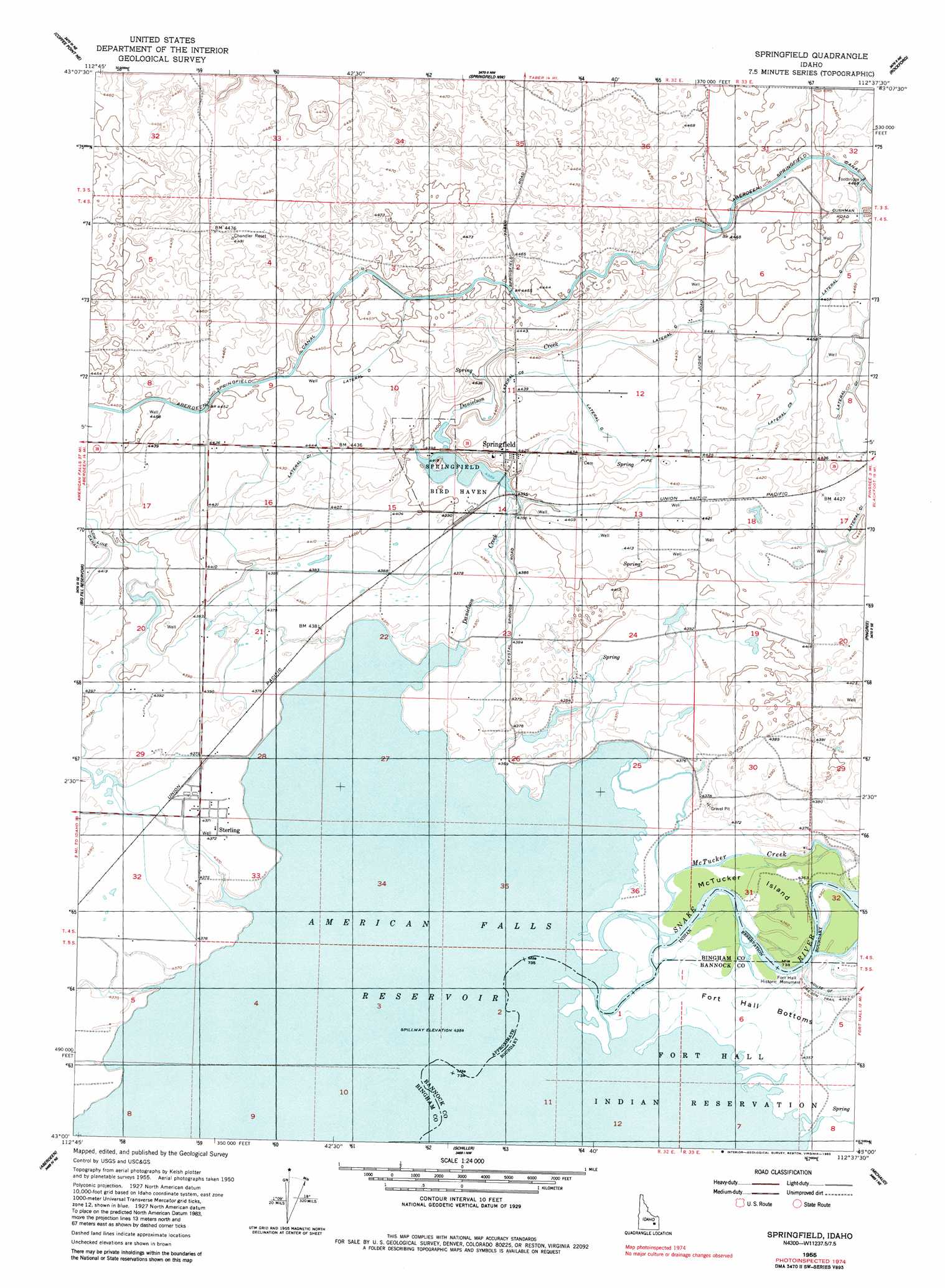
USGS Topo Quad 43112a6 - 1:24,000 scale
| Topo Map Name: | Springfield |
| USGS Topo Quad ID: | 43112a6 |
| Print Size: | ca. 21 1/4" wide x 27" high |
| Southeast Coordinates: | 43° N latitude / 112.625° W longitude |
| Map Center Coordinates: | 43.0625° N latitude / 112.6875° W longitude |
| U.S. State: | ID |
| Filename: | o43112a6.jpg |
| Download Map JPG Image: | Springfield topo map 1:24,000 scale |
| Map Type: | Topographic |
| Topo Series: | 7.5´ |
| Map Scale: | 1:24,000 |
| Source of Map Images: | United States Geological Survey (USGS) |
| Alternate Map Versions: |
Springfield ID 1955, updated 1957 Download PDF Buy paper map Springfield ID 1955, updated 1983 Download PDF Buy paper map Springfield ID 1955, updated 1983 Download PDF Buy paper map Springfield ID 2010 Download PDF Buy paper map Springfield ID 2013 Download PDF Buy paper map |
1:24,000 Topo Quads surrounding Springfield
Rock Butte |
Lava Lake Reservoir |
Taber |
Olsen |
Baldy Knoll |
Coffee Point |
Coffee Point Ne |
Springfield Nw |
Rockford |
Moreland |
Coffee Point Sw |
Big Fill Reservoir |
Springfield |
Pingree |
Fort Hall |
American Falls Nw |
Aberdeen |
Schiller |
Michaud |
Pocatello North |
American Falls Sw |
American Falls |
Wheatgrass Bench |
Michaud Creek |
Pocatello South |
> Back to 43112a1 at 1:100,000 scale
> Back to 43112a1 at 1:250,000 scale
> Back to U.S. Topo Maps home
Springfield topo map: Gazetteer
Springfield: Canals
Lateral C elevation 1355m 4445′Lateral C 1 elevation 1357m 4452′
Lateral C 5 elevation 1357m 4452′
Lateral C 6 elevation 1356m 4448′
Lateral C3 elevation 1349m 4425′
Lateral D elevation 1356m 4448′
Lateral D 1 elevation 1352m 4435′
Springfield: Islands
McTucker Island elevation 1330m 4363′Springfield: Parks
Fort Hall Historic Monument elevation 1330m 4363′Springfield Bird Haven elevation 1339m 4393′
Springfield: Populated Places
Springfield elevation 1350m 4429′Sterling elevation 1334m 4376′
Springfield: Streams
Danielson Creek elevation 1331m 4366′McTucker Creek elevation 1330m 4363′
Springfield: Valleys
Snake River Valley elevation 1330m 4363′Springfield digital topo map on disk
Buy this Springfield topo map showing relief, roads, GPS coordinates and other geographical features, as a high-resolution digital map file on DVD: