Woodville Topo Map Idaho
To zoom in, hover over the map of Woodville
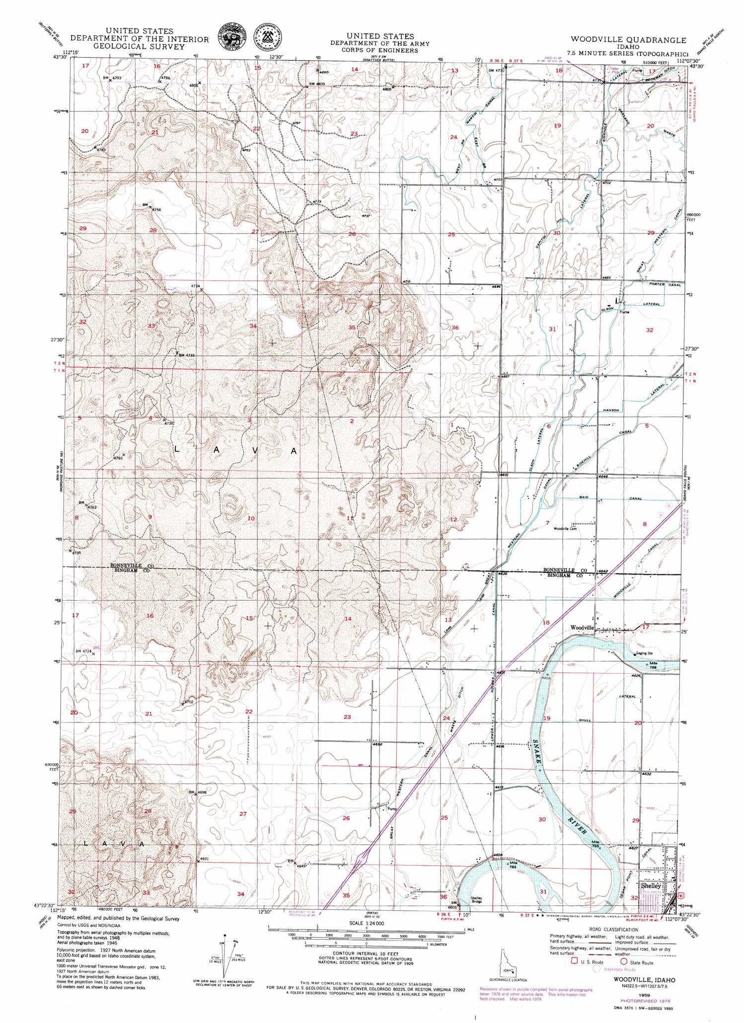
USGS Topo Quad 43112d2 - 1:24,000 scale
| Topo Map Name: | Woodville |
| USGS Topo Quad ID: | 43112d2 |
| Print Size: | ca. 21 1/4" wide x 27" high |
| Southeast Coordinates: | 43.375° N latitude / 112.125° W longitude |
| Map Center Coordinates: | 43.4375° N latitude / 112.1875° W longitude |
| U.S. State: | ID |
| Filename: | o43112d2.jpg |
| Download Map JPG Image: | Woodville topo map 1:24,000 scale |
| Map Type: | Topographic |
| Topo Series: | 7.5´ |
| Map Scale: | 1:24,000 |
| Source of Map Images: | United States Geological Survey (USGS) |
| Alternate Map Versions: |
Woodville ID 1948, updated 1954 Download PDF Buy paper map Woodville ID 1950 Download PDF Buy paper map Woodville ID 1959, updated 1979 Download PDF Buy paper map Woodville ID 2010 Download PDF Buy paper map Woodville ID 2013 Download PDF Buy paper map |
1:24,000 Topo Quads surrounding Woodville
Kettle Butte Nw |
Kettle Butte Ne |
Roberts |
Lewisville |
Rigby |
Kettle Butte |
Butterfly Butte |
Shattuck Butte |
Idaho Falls North |
Ucon |
Morgans Pasture Nw |
Morgans Pasture Ne |
Woodville |
Idaho Falls South |
Ammon |
Baldy Knoll |
Rose |
Firth |
Goshen |
Wolverine |
Moreland |
Blackfoot |
Lincoln Creek |
Higham Peak |
Miner Creek |
> Back to 43112a1 at 1:100,000 scale
> Back to 43112a1 at 1:250,000 scale
> Back to U.S. Topo Maps home
Woodville topo map: Gazetteer
Woodville: Bridges
Shelley Bridge elevation 1400m 4593′Woodville: Canals
Bain Canal elevation 1418m 4652′Capital Hill Lateral elevation 1434m 4704′
East Branch Martin Canal elevation 1440m 4724′
Great Western Canal elevation 1424m 4671′
Hansen Lateral elevation 1423m 4668′
Lower Holmes Canal elevation 1411m 4629′
Oakland Waste elevation 1427m 4681′
Olson Lateral elevation 1422m 4665′
Shull Lateral elevation 1411m 4629′
Sinkhole elevation 1437m 4714′
The Slough elevation 1407m 4616′
Waste Ditch elevation 1406m 4612′
West Branch Martin Canal elevation 1435m 4708′
Woodville Canal elevation 1417m 4648′
Woodville: Populated Places
Woodville elevation 1414m 4639′Woodville digital topo map on disk
Buy this Woodville topo map showing relief, roads, GPS coordinates and other geographical features, as a high-resolution digital map file on DVD: