Champagne Creek Topo Map Idaho
To zoom in, hover over the map of Champagne Creek
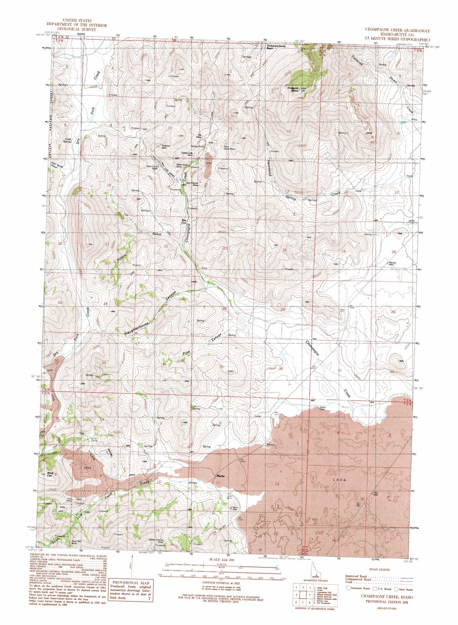
USGS Topo Quad 43113e5 - 1:24,000 scale
| Topo Map Name: | Champagne Creek |
| USGS Topo Quad ID: | 43113e5 |
| Print Size: | ca. 21 1/4" wide x 27" high |
| Southeast Coordinates: | 43.5° N latitude / 113.5° W longitude |
| Map Center Coordinates: | 43.5625° N latitude / 113.5625° W longitude |
| U.S. State: | ID |
| Filename: | o43113e5.jpg |
| Download Map JPG Image: | Champagne Creek topo map 1:24,000 scale |
| Map Type: | Topographic |
| Topo Series: | 7.5´ |
| Map Scale: | 1:24,000 |
| Source of Map Images: | United States Geological Survey (USGS) |
| Alternate Map Versions: |
Champagne Creek ID 1991, updated 1991 Download PDF Buy paper map Champagne Creek ID 2011 Download PDF Buy paper map Champagne Creek ID 2013 Download PDF Buy paper map |
| FStopo: | US Forest Service topo Champagne Creek is available: Download FStopo PDF Download FStopo TIF |
1:24,000 Topo Quads surrounding Champagne Creek
Copper Basin Knob |
Shelly Mountain |
Big Blind Canyon |
Darlington |
Ramshorn Canyon |
Smiley Mountain |
Miller Peak |
Grouse |
Appendicitis Hill |
Arco North |
Trail Creek |
Blizzard Mountain North |
Champagne Creek |
Nichols Reservoir |
Arco South |
Fish Creek Reservoir |
Blizzard Mountain South |
Inferno Cone |
The Watchman |
Fingers Butte |
Paddelford Flat |
Little Park |
North Laidlaw Butte |
Fissure Butte |
Pratt Butte |
> Back to 43113e1 at 1:100,000 scale
> Back to 43112a1 at 1:250,000 scale
> Back to U.S. Topo Maps home
Champagne Creek topo map: Gazetteer
Champagne Creek: Canals
Martins Ditch elevation 1850m 6069′Champagne Creek: Mines
Ella Mine elevation 2033m 6669′Golden Chariot Mine elevation 2015m 6610′
Hub Mine elevation 2037m 6683′
Last Chance Mine elevation 1910m 6266′
Oxide Lode Mine elevation 1922m 6305′
Reliance Mine elevation 2023m 6637′
Saint Louis Mine elevation 1965m 6446′
Silver Bell Mine elevation 1993m 6538′
Valley Arco Mine elevation 1913m 6276′
Champagne Creek: Populated Places
Era elevation 1823m 5980′Martin elevation 1721m 5646′
Champagne Creek: Springs
Cold Spring elevation 1995m 6545′Champagne Creek: Streams
Lava Creek elevation 1710m 5610′South Lava Creek elevation 1751m 5744′
Champagne Creek: Summits
Black Cap elevation 2294m 7526′Timbered Dome elevation 2538m 8326′
Champagne Creek: Valleys
Cold Spring Canyon elevation 2001m 6564′Poison Gulch elevation 1801m 5908′
Price Canyon elevation 1712m 5616′
Saint Louis Canyon elevation 1857m 6092′
Slaughterhouse Canyon elevation 1747m 5731′
Champagne Creek digital topo map on disk
Buy this Champagne Creek topo map showing relief, roads, GPS coordinates and other geographical features, as a high-resolution digital map file on DVD: