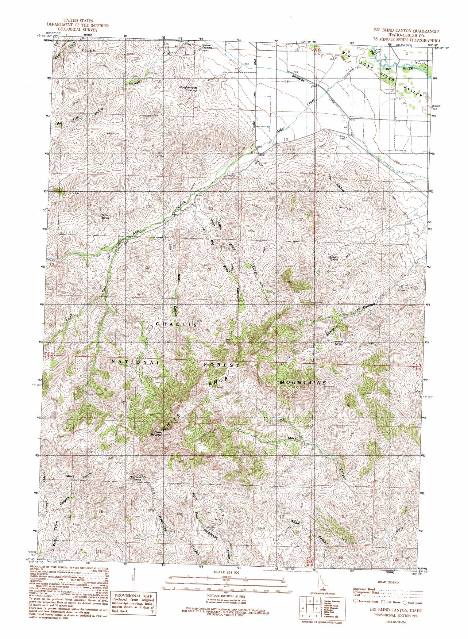
Big Blind Canyon Topo Map Idaho
To zoom in, hover over the map of Big Blind Canyon
USGS Topo Quad 43113g5 - 1:24,000 scale
| Topo Map Name: | Big Blind Canyon |
| USGS Topo Quad ID: | 43113g5 |
| Print Size: | ca. 21 1/4" wide x 27" high |
| Southeast Coordinates: | 43.75° N latitude / 113.5° W longitude |
| Map Center Coordinates: | 43.8125° N latitude / 113.5625° W longitude |
| U.S. State: | ID |
| Filename: | o43113g5.jpg |
| Download Map JPG Image: | Big Blind Canyon topo map 1:24,000 scale |
| Map Type: | Topographic |
| Topo Series: | 7.5´ |
| Map Scale: | 1:24,000 |
| Source of Map Images: | United States Geological Survey (USGS) |
| Alternate Map Versions: |
Big Blind Canyon ID 1991, updated 1991 Download PDF Buy paper map Big Blind Canyon ID 2011 Download PDF Buy paper map Big Blind Canyon ID 2013 Download PDF Buy paper map |
| FStopo: | US Forest Service topo Big Blind Canyon is available: Download FStopo PDF Download FStopo TIF |
1:24,000 Topo Quads surrounding Big Blind Canyon
Elkhorn Creek |
Leatherman Peak |
Massacre Mountain |
Warren Mountain |
Hawley Mountain |
Lehman Butte |
Mackay Reservoir |
Mackay |
Methodist Creek |
Sunset Peak |
Copper Basin Knob |
Shelly Mountain |
Big Blind Canyon |
Darlington |
Ramshorn Canyon |
Smiley Mountain |
Miller Peak |
Grouse |
Appendicitis Hill |
Arco North |
Trail Creek |
Blizzard Mountain North |
Champagne Creek |
Nichols Reservoir |
Arco South |
> Back to 43113e1 at 1:100,000 scale
> Back to 43112a1 at 1:250,000 scale
> Back to U.S. Topo Maps home
Big Blind Canyon topo map: Gazetteer
Big Blind Canyon: Canals
Darlington Ditch elevation 1780m 5839′Rodger Ditch elevation 1774m 5820′
Big Blind Canyon: Populated Places
Alder City (historical) elevation 1756m 5761′Big Blind Canyon: Springs
Fallini Spring elevation 2091m 6860′Granite Spring elevation 2010m 6594′
Jenson Spring elevation 2107m 6912′
Mountain Spring elevation 2429m 7969′
Slaughterhouse Springs elevation 1840m 6036′
Big Blind Canyon: Streams
Alder Creek elevation 1756m 5761′Right Fork Willow Creek elevation 2014m 6607′
South Fork Alder Creek elevation 1935m 6348′
Big Blind Canyon: Summits
Sheep Mountain elevation 2919m 9576′Big Blind Canyon: Valleys
Bedy Canyon elevation 1889m 6197′Big Blind Canyon elevation 1873m 6145′
Blind Canyon elevation 2269m 7444′
Dry Hollow elevation 1781m 5843′
Little Blind Canyon elevation 1848m 6062′
Big Blind Canyon digital topo map on disk
Buy this Big Blind Canyon topo map showing relief, roads, GPS coordinates and other geographical features, as a high-resolution digital map file on DVD: