Porphyry Peak Topo Map Idaho
To zoom in, hover over the map of Porphyry Peak
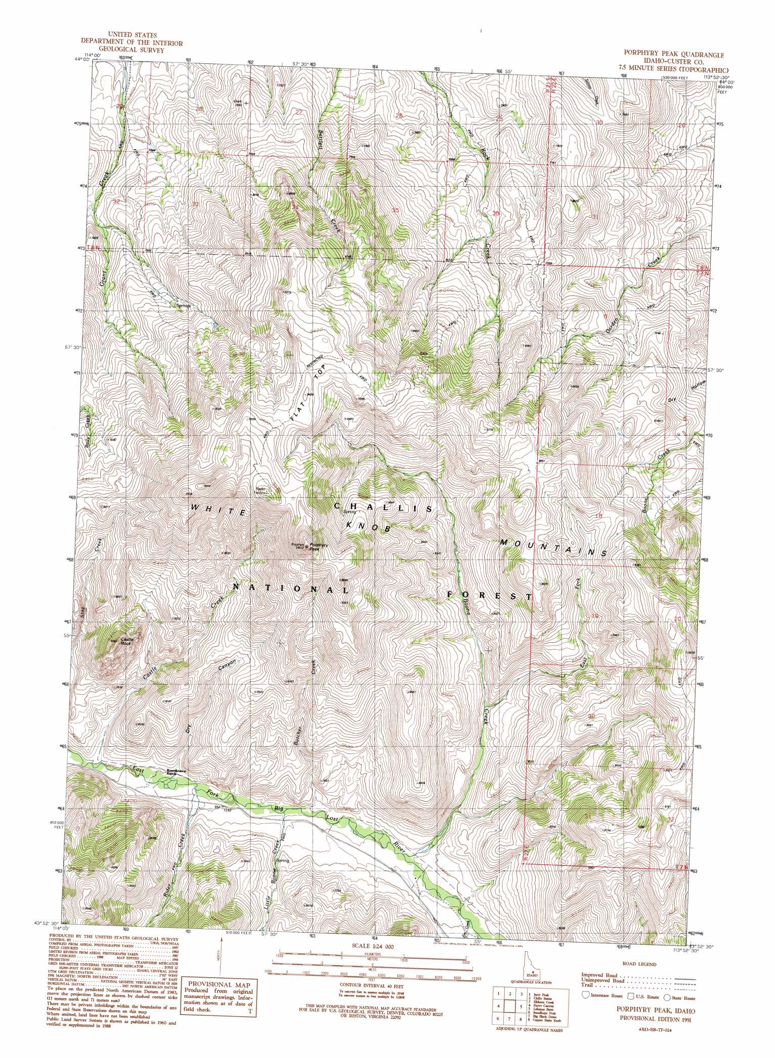
USGS Topo Quad 43113h8 - 1:24,000 scale
| Topo Map Name: | Porphyry Peak |
| USGS Topo Quad ID: | 43113h8 |
| Print Size: | ca. 21 1/4" wide x 27" high |
| Southeast Coordinates: | 43.875° N latitude / 113.875° W longitude |
| Map Center Coordinates: | 43.9375° N latitude / 113.9375° W longitude |
| U.S. State: | ID |
| Filename: | o43113h8.jpg |
| Download Map JPG Image: | Porphyry Peak topo map 1:24,000 scale |
| Map Type: | Topographic |
| Topo Series: | 7.5´ |
| Map Scale: | 1:24,000 |
| Source of Map Images: | United States Geological Survey (USGS) |
| Alternate Map Versions: |
Porphyry Peak ID 1991, updated 1991 Download PDF Buy paper map Porphyry Peak ID 2011 Download PDF Buy paper map Porphyry Peak ID 2013 Download PDF Buy paper map |
| FStopo: | US Forest Service topo Porphyry Peak is available: Download FStopo PDF Download FStopo TIF |
1:24,000 Topo Quads surrounding Porphyry Peak
The Paint Pot |
Horse Basin |
Dickey Peak |
Borah Peak |
Burnt Creek |
Herd Lake |
Jerry Peak |
Chilly Buttes |
Elkhorn Creek |
Leatherman Peak |
Herd Peak |
Harry Canyon |
Porphyry Peak |
Lehman Butte |
Mackay Reservoir |
Phi Kappa Mountain |
Standhope Peak |
Big Black Dome |
Copper Basin Knob |
Shelly Mountain |
Hyndman Peak |
Grays Peak |
Star Hope Mine |
Smiley Mountain |
Miller Peak |
> Back to 43113e1 at 1:100,000 scale
> Back to 43112a1 at 1:250,000 scale
> Back to U.S. Topo Maps home
Porphyry Peak topo map: Gazetteer
Porphyry Peak: Streams
Boone Creek elevation 2238m 7342′Butcher Creek elevation 2220m 7283′
Castle Creek elevation 2196m 7204′
East Fork Boone Creek elevation 2303m 7555′
Fox Creek elevation 2251m 7385′
Little Boone Creek elevation 2216m 7270′
Rider Creek elevation 2205m 7234′
Porphyry Peak: Summits
Castle Rock elevation 2660m 8727′Flat Top elevation 2859m 9379′
Porphyry Peak elevation 3041m 9977′
Porphyry Peak: Valleys
Dry Canyon elevation 2205m 7234′Porphyry Peak digital topo map on disk
Buy this Porphyry Peak topo map showing relief, roads, GPS coordinates and other geographical features, as a high-resolution digital map file on DVD: