Thorn Creek Se Topo Map Idaho
To zoom in, hover over the map of Thorn Creek Se
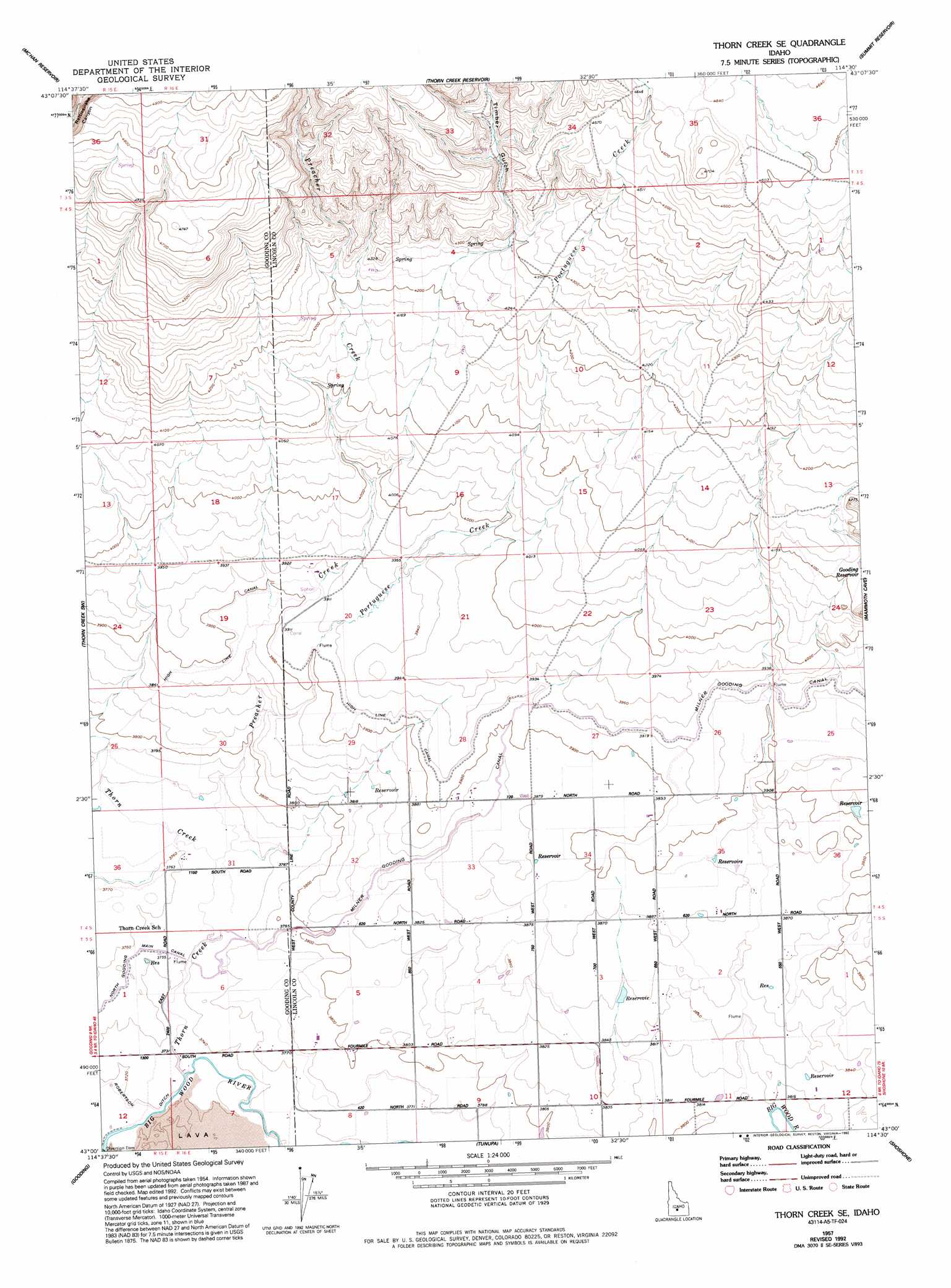
USGS Topo Quad 43114a5 - 1:24,000 scale
| Topo Map Name: | Thorn Creek Se |
| USGS Topo Quad ID: | 43114a5 |
| Print Size: | ca. 21 1/4" wide x 27" high |
| Southeast Coordinates: | 43° N latitude / 114.5° W longitude |
| Map Center Coordinates: | 43.0625° N latitude / 114.5625° W longitude |
| U.S. State: | ID |
| Filename: | o43114a5.jpg |
| Download Map JPG Image: | Thorn Creek Se topo map 1:24,000 scale |
| Map Type: | Topographic |
| Topo Series: | 7.5´ |
| Map Scale: | 1:24,000 |
| Source of Map Images: | United States Geological Survey (USGS) |
| Alternate Map Versions: |
Thorn Creek SE ID 1957, updated 1958 Download PDF Buy paper map Thorn Creek SE ID 1957, updated 1979 Download PDF Buy paper map Thorn Creek SE ID 1957, updated 1992 Download PDF Buy paper map Thorn Creek SE ID 2010 Download PDF Buy paper map Thorn Creek SE ID 2013 Download PDF Buy paper map |
1:24,000 Topo Quads surrounding Thorn Creek Se
Fairfield |
Spring Creek Reservoir |
Macon |
Magic Reservoir West |
Magic Reservoir East |
Fir Grove Mountain |
Mchan Reservoir |
Thorn Creek Reservoir |
Summit Reservoir |
Shoshone Ice Cave |
Mckinney Butte |
Thorn Creek Sw |
Thorn Creek Se |
Mammoth Cave |
Kinzie Butte |
Gooding Butte |
Gooding |
Tunupa |
Shoshone |
Dietrich |
Tuttle |
Wendell |
Gooding Se |
Shoshone Sw |
Shoshone Se |
> Back to 43114a1 at 1:100,000 scale
> Back to 43114a1 at 1:250,000 scale
> Back to U.S. Topo Maps home
Thorn Creek Se topo map: Gazetteer
Thorn Creek Se: Canals
High Line Canal elevation 1194m 3917′Thorn Creek Se: Dams
Patterson Dam elevation 1407m 4616′Thorn Creek Se: Reservoirs
Gooding Reservoir elevation 1254m 4114′Seven Hundred Reservoir elevation 1387m 4550′
Thorn Creek Se: Streams
Portuguese Creek elevation 1165m 3822′Preacher Creek elevation 1144m 3753′
Thorn Creek elevation 1134m 3720′
Thorn Creek Se: Valleys
Timber Gulch elevation 1311m 4301′Thorn Creek Se digital topo map on disk
Buy this Thorn Creek Se topo map showing relief, roads, GPS coordinates and other geographical features, as a high-resolution digital map file on DVD: