Harry Canyon Topo Map Idaho
To zoom in, hover over the map of Harry Canyon
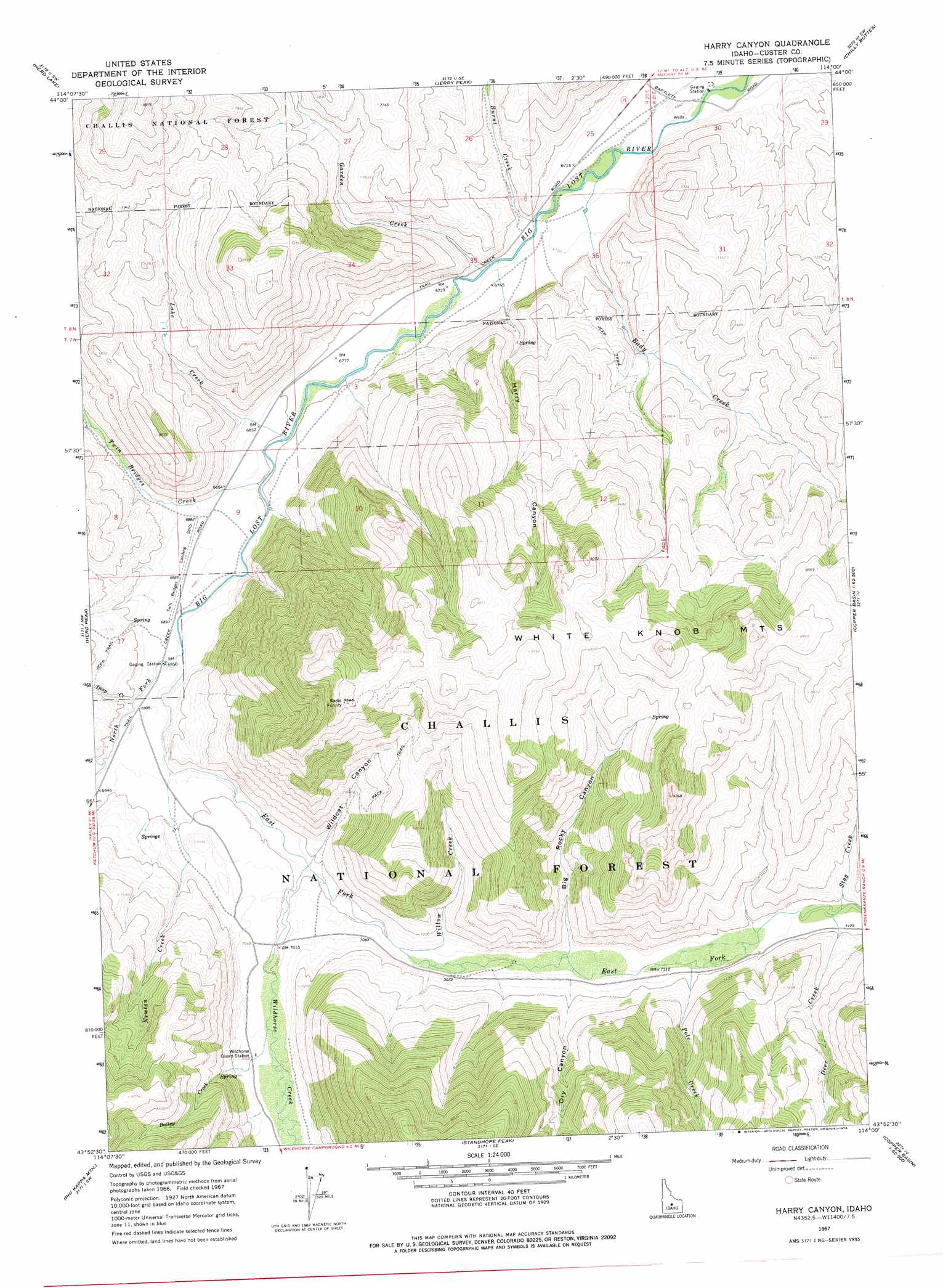
USGS Topo Quad 43114h1 - 1:24,000 scale
| Topo Map Name: | Harry Canyon |
| USGS Topo Quad ID: | 43114h1 |
| Print Size: | ca. 21 1/4" wide x 27" high |
| Southeast Coordinates: | 43.875° N latitude / 114° W longitude |
| Map Center Coordinates: | 43.9375° N latitude / 114.0625° W longitude |
| U.S. State: | ID |
| Filename: | o43114h1.jpg |
| Download Map JPG Image: | Harry Canyon topo map 1:24,000 scale |
| Map Type: | Topographic |
| Topo Series: | 7.5´ |
| Map Scale: | 1:24,000 |
| Source of Map Images: | United States Geological Survey (USGS) |
| Alternate Map Versions: |
Harry Canyon ID 1967, updated 1971 Download PDF Buy paper map Harry Canyon ID 1967, updated 1978 Download PDF Buy paper map Harry Canyon ID 2011 Download PDF Buy paper map Harry Canyon ID 2013 Download PDF Buy paper map |
| FStopo: | US Forest Service topo Harry Canyon is available: Download FStopo PDF Download FStopo TIF |
1:24,000 Topo Quads surrounding Harry Canyon
Ziegler Basin |
The Paint Pot |
Horse Basin |
Dickey Peak |
Borah Peak |
Bowery Peak |
Herd Lake |
Jerry Peak |
Chilly Buttes |
Elkhorn Creek |
Meridian Peak |
Herd Peak |
Harry Canyon |
Porphyry Peak |
Lehman Butte |
Rock Roll Canyon |
Phi Kappa Mountain |
Standhope Peak |
Big Black Dome |
Copper Basin Knob |
Sun Valley |
Hyndman Peak |
Grays Peak |
Star Hope Mine |
Smiley Mountain |
> Back to 43114e1 at 1:100,000 scale
> Back to 43114a1 at 1:250,000 scale
> Back to U.S. Topo Maps home
Harry Canyon topo map: Gazetteer
Harry Canyon: Airports
Star 'S' Ranch Airport elevation 2049m 6722′Twin Bridges Airport elevation 2103m 6899′
Harry Canyon: Streams
Bady Creek elevation 2031m 6663′Bailey Creek elevation 2141m 7024′
Burnt Creek elevation 2038m 6686′
Deep Creek elevation 2096m 6876′
Deer Creek elevation 2183m 7162′
East Fork Big Lost River elevation 2091m 6860′
Garden Creek elevation 2045m 6709′
Lake Creek elevation 2068m 6784′
Newton Creek elevation 2101m 6893′
North Fork Big Lost River elevation 2091m 6860′
Pole Creek elevation 2167m 7109′
Stag Creek elevation 2183m 7162′
Twin Bridges Creek elevation 2072m 6797′
Wildhorse Creek elevation 2120m 6955′
Willow Creek elevation 2143m 7030′
Harry Canyon: Summits
White Knob Mountains elevation 2808m 9212′Harry Canyon: Valleys
Banana Gulch elevation 2184m 7165′Big Rocky Canyon elevation 2165m 7103′
Dry Canyon elevation 2172m 7125′
Harry Canyon elevation 2043m 6702′
Wildcat Canyon elevation 2124m 6968′
Harry Canyon digital topo map on disk
Buy this Harry Canyon topo map showing relief, roads, GPS coordinates and other geographical features, as a high-resolution digital map file on DVD: